Skip to search
Skip to main content
Skip to first result
Search
You Searched For
Genre
World maps.
Language
Latin
Search Results
Creator:
Published / Created:
[1569]
Call Number:
11 1550
Image Count:
2
Resource Type:
Maps, Atlases & Globes
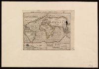
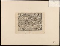
Alternative Title:
Erst general oder gemeine tafeln
Description:
"DK," the initials of woodcutter David Kandel, appear in lower left-hand corner.
Publisher:
[Henricpetrina],
Subject (Name):
Kandel, David, -1587
Subject (Topic):
World maps--Early works to 1800.
Found in:
Beinecke Rare Book and Manuscript Library > Das erst general, inhaltend die beschreibung und den circkel des gantzen erdtreichs und moeres [cartographic material] / Münster, cosmographer.
Creator:
Published / Created:
[1607]
Call Number:
11 1607
Container / Volume:
BRBL_00003
Image Count:
2
Resource Type:
Maps, Atlases & Globes
Description:
Imperfect: two small holes at upper right corner where oxidized by pigment. Label on verso with manuscript number "550/149." Cross collection no. 6. Mounted on paper.
Publisher:
[Jodocus Hondius],
Subject (Topic):
World maps--Early works to 1800.
Found in:
Beinecke Rare Book and Manuscript Library > Designatio orbis Christiani.
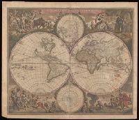
Creator:
Published / Created:
[1658]
Call Number:
11 1658
Image Count:
1
Resource Type:
Maps, Atlases & Globes
Description:
"J. de Vissscher sculpsit".
Publisher:
[Jan Jansson],
Subject (Name):
Berchem, Nicolaas Pietersz, 1620-1683., Jansson, Jan, 1588-1664. Novus Atlas., and Visscher, Jan de, 1633-approximately 1692.
Subject (Topic):
World maps--Early works to 1800
Found in:
Beinecke Rare Book and Manuscript Library > Orbis terrarum nova et accuratissima tabula / auctore Nicolao Visscher.
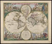
Creator:
Call Number:
11 1746A
Image Count:
1
Resource Type:
Maps, Atlases & Globes
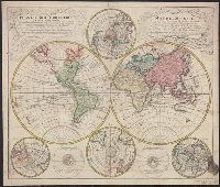
Alternative Title:
Mappe-monde qui représente les deux hemisphères savoir celui de l'orient et celui de l'occident, tirée des quatre cartes générales de feu M. le profess. Hasius and Planiglobii terrestris mappa vniversalis
Description:
Includes color illustrations, 4 ancillary maps showing poles, and 2 diagrams.
Subject (Name):
Hase, Johann Matthias, 1684-1742. and Homann Erben (Firm), publisher.
Subject (Topic):
Religion--Maps--Early works to 1800. and World maps--Early works to 1800.
Found in:
Beinecke Rare Book and Manuscript Library > Planiglobii terrestris mappa universalis utrumq[ue] hemisphaerium orient. et occidentale repraesentans, ex IV. mappis generalibus, Hasianis composita et adjectis ceteris hemisphaeriis / designata a G.M. Lowizio ; excudentibus Homann. Heredibus = Mappe-monde qui représente les deux hemisphères savoir celui de l'orient et celui de l'occident, tirée des quatre cartes générales de feu M. le profess. Hasius / dressée par M. G.M. Lowitz, et publiée par les Héritiers de Homann.
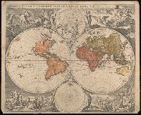
Creator:
Published / Created:
[1573]
Call Number:
11 1570
Container / Volume:
BRBL_00680
Image Count:
2
Resource Type:
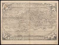
Maps, Atlases & Globes
Alternative Title:
Typus orbis terrarum
Description:
"Quid ei potest videri magnum in rebus humanis, cui aeternitas omnis, totiusque mundi nota sit magnitudo. Cicero".
Publisher:
[Abraham Ortelius],
Subject (Name):
Hogenberg, Frans, approximately 1539-1590, engraver. and Ortelius, Abraham, 1527-1598. Theatrum orbis terrarum.
Subject (Topic):
World maps--Early works to 1800.
Found in:
Beinecke Rare Book and Manuscript Library > Typvs orbis terrarvm / Franciscus Hogenbergus sculpsit.
Branch:v1.68.7 ,Deployed:2025-07-09T09:08:31-04:00