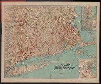
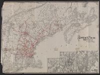
Search
You Searched For
Search Results
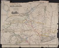
- Creator:
- Poole Brothers
- Published / Created:
- [1903]
- Call Number:
- 76gme 1903
- Container / Volume:
- BRBL_00446A
- Image Count:
- 1
- Resource Type:
- Maps, Atlases & Globes
- Subject (Topic):
- Ferries--New England--Maps
- Found in:
- Beinecke Rare Book and Manuscript Library > The New York, New Haven and Hartford Railroad and connections.
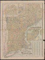
- Creator:
- National Publishing Company (Boston, Mass.)
- Published / Created:
- 1898
- Call Number:
- 76 1898
- Container / Volume:
- BRBL_00445
- Image Count:
- 1
- Resource Type:
- Maps, Atlases & Globes
- Alternative Title:
- Map of New England showing state
- Subject (Geographic):
- New England--Maps
- Subject (Topic):
- Post Office Buildings--New England
- Found in:
- Beinecke Rare Book and Manuscript Library > New post office, township, county and railroad map of New England : with distances.
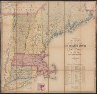
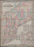
- Creator:
- Williams, Alexander
- Published / Created:
- 1852
- Call Number:
- 76GM 1852
- Container / Volume:
- BRBL_00446
- Image Count:
- 1
- Resource Type:
- Maps, Atlases & Globes
- Alternative Title:
- Telegraph and rail road map of the New
- Subject (Geographic):
- New England--Maps
- Subject (Topic):
- Railroads--New England--Maps
- Found in:
- Beinecke Rare Book and Manuscript Library > Williams' telegraph and rail road map of the New England states : Eastern portion of New York state and Canada/ compiled from the most authentic sources by Alexander Williams.
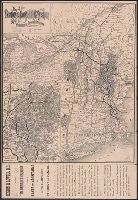
- Creator:
- Rand Avery Supply Co
- Published / Created:
- 1885
- Call Number:
- 753gme 1885
- Container / Volume:
- BRBL_00415
- Image Count:
- 2
- Resource Type:
- Maps, Atlases & Globes
- Description:
- Covers New England excluding Maine, and
- Subject (Topic):
- Railroads--New England--Maps
- Found in:
- Beinecke Rare Book and Manuscript Library > Map of the Boston & Lowell Railroad System : with its principal connections.
- Creator:
- Rand Avery Supply Co
- Published / Created:
- [1911?]
- Call Number:
- 76gme 1910
- Container / Volume:
- BRBL_00446A
- Image Count:
- 1
- Resource Type:
- Maps, Atlases & Globes
- Subject (Geographic):
- New England--Maps
- Subject (Topic):
- Railroads--New England--Maps
- Found in:
- Beinecke Rare Book and Manuscript Library > Boston & Maine Railroad and connections / Rand Avery Supply Co.
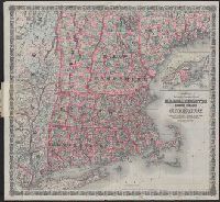
- Creator:
- G.W. & C.B. Colton & Co
- Published / Created:
- 1886
- Call Number:
- 76 1886
- Container / Volume:
- BRBL_00445
- Image Count:
- 1
- Resource Type:
- Maps, Atlases & Globes
- Subject (Geographic):
- New England--Maps
- Subject (Topic):
- Railroads--New England--Maps
- Found in:
- Beinecke Rare Book and Manuscript Library > Colton's railroad & township map of Massachusetts, Rhode Island and Connecticut : with parts of Maine, New Hampshire, Vermont & New York.
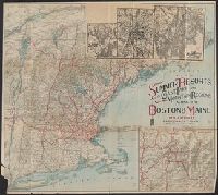
- Creator:
- Boston and Maine Railroad. General Passenger Dept
- Published / Created:
- [1900?]
- Call Number:
- 76gme 1900
- Container / Volume:
- BRBL_00446A
- Image Count:
- 2
- Resource Type:
- Maps, Atlases & Globes
- Subject (Geographic):
- New England--Maps
- Subject (Topic):
- Railroads--New England--Maps
- Found in:
- Beinecke Rare Book and Manuscript Library > Summer resorts of the coast, lake, and mountain regions along the Boston & Maine Railroad and connections.
- Creator:
- Swett and Powers (Firm)
- Published / Created:
- [ca. 1851?]
- Call Number:
- 76gme 1850
- Container / Volume:
- BRBL_00446A
- Image Count:
- 1
- Resource Type:
- Maps, Atlases & Globes
- Subject (Topic):
- Railroads--New England--Maps
- Found in:
- Beinecke Rare Book and Manuscript Library > Map of the New York & Boston Railway : with its connections with other railways.
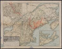
- Creator:
- Colton, G. Woolworth (George Woolworth), 1827-1901
- Published / Created:
- 1866, c1860.
- Call Number:
- 753 1866C
- Container / Volume:
- BRBL_00415
- Image Count:
- 1
- Resource Type:
- Maps, Atlases & Globes
- Alternative Title:
- New England
- Description:
- Area includes all of New England and
- Subject (Geographic):
- New England--Maps
- Subject (Topic):
- Railroads--New England--Maps
- Found in:
- Beinecke Rare Book and Manuscript Library > G. Woolworth Colton's railroad, township & distance map of New England : with adjacent portions of New York, Canada & New Brunswick.
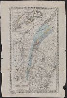
- Published / Created:
- 1890?]
- Call Number:
- 76 1890
- Container / Volume:
- BRBL_00445
- Image Count:
- 1
- Resource Type:
- Maps, Atlases & Globes
- Description:
- Covers New England and the Maritime
- Subject (Geographic):
- New England--Maps
- Subject (Topic):
- Railroads--New England--Maps
- Found in:
- Beinecke Rare Book and Manuscript Library > Map of the Maine Central R.R. : the White Mountains & Mount Desert route / Rand Avery Supply Co., engr's.
- Creator:
- Geo. K. Snow & Hapgood (Firm)
- Published / Created:
- [1863]
- Call Number:
- 76gme 1863
- Container / Volume:
- BRBL_00446A
- Image Count:
- 2
- Resource Type:
- Maps, Atlases & Globes
- Subject (Topic):
- Railroads--New England--Maps
- Found in:
- Beinecke Rare Book and Manuscript Library > Map of railways in the New England states : engraved expressly for Snow's Pathfinder Railway Guide. 1863.
- Creator:
- Goldthwait, J. H
- Published / Created:
- 1861
- Call Number:
- 75 1861D
- Container / Volume:
- BRBL_00402
- Image Count:
- 1
- Resource Type:
- Maps, Atlases & Globes
- Alternative Title:
- Map of the railroads of New England and
- Subject (Topic):
- Railroads--New England--Maps
- Found in:
- Beinecke Rare Book and Manuscript Library > Goldthwait's map of the United States & Canada : exhibiting the railroads with their distances, single and double tracks and width of gauge, and the time compared with noon at Washington & Greenwich / by J.H. Goldthwait.
- Creator:
- Richmond, Van R
- Published / Created:
- 1869
- Call Number:
- 771gme 1869
- Container / Volume:
- BRBL_00494
- Image Count:
- 1
- Resource Type:
- Maps, Atlases & Globes
- Subject (Topic):
- Railroads--New England--Maps
- Found in:
- Beinecke Rare Book and Manuscript Library > Map showing the location of the N.Y. & Oswego Midland R.R. with existing and proposed connection, January 1st 1869, [by Van R. Richmond, State Engr. & Surv.].
- Creator:
- Hitchcock, Charles H. (Charles Henry), 1836-1919
- Published / Created:
- 1865]
- Call Number:
- 734 1865
- Container / Volume:
- BRBL_00379
- Image Count:
- 1
- Resource Type:
- Maps, Atlases & Globes
- Subject (Topic):
- Railroads--New England--Maps
- Found in:
- Beinecke Rare Book and Manuscript Library > Map illustrating the geological position of the Golconda gold mines / by C.H. Hitchcock ; to which has been added the railway connections by J.H. Colton.