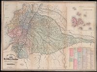
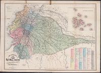
"Delineada en vista de las cartas de Don Pedro Maldonado, el Baron de Humboldt, Mr. Wisse, la de las sontas de las costas por M.M. Filzroy i H. Kellet i las particular, Includes table of names of provinces, cantons, parishes, etc., and Relief shown by hachures.
"Delineada en vista de las cartas de Don Pedro Maldonado, el Baron de Humboldt, Mr. Wisse, la de las sontas de las costas por M.M. Filzroy i H. Kellet i las particular, Includes table of names of provinces, cantons, parishes, etc., and Relief shown by hachures.
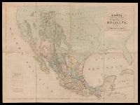
"Engraved by B.R. Davies, 16 George Str. Euston Squ., London. From the original survey made by order of the Mexican Government.", "Esta edicion se hace provicionalmente mientras se concluye la Carta en Escala mayor. Pedro Garcia Conde.", Prime meridian: Mexico City., and Relief shown by hachures.
Publisher:
s.n.,
Subject (Geographic):
Mexico--Maps and West (U.S.)--Maps
Subject (Name):
Davies, Benjamin Rees and García Conde, Pedro, 1806-1851
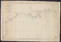
"Constructed, projected and drawn by Fred D. Stuart, hydrographer, late of the U.S. Ex. Ex.", "Entered according to act of Congress in the 1851 by Cadwalader Ringgold ....", "Sheet no. 1.", Inset view: Entrance to San Francisco., and Place names in English and Spanish.
Publisher:
C.B. Graham, Lithr.,
Subject (Geographic):
San Francisco Bay (Calif.)--Maps and San Francisco Bay Area (Calif.)--Maps
Subject (Name):
Blunt, Simon Fraser, d. 1854, Graham, C. B. (Curtis B.), and Stuart, Fred D
"Entered according to act of Congress in the year 1851 by Cadwalader Ringgold ....", "Projected, constructed & drawn by Fred D. Stuart, hydrographer, late of the U.S. Ex. Ex. ; assisted by A.H. Campbell, civil engineer.", "Sheet no. 2.", and Inset views: Mark for invincible buoy, north extreme of Marin Is. on with clump of trees north of San Rafael -- Mark for invincible buoy, Point Smith, east end of Angel I. on with Signal Hill.
Publisher:
C.B. Graham, Lithr.,
Subject (Geographic):
San Francisco Bay (Calif.)--Maps, San Francisco Bay Area (Calif.)--Maps, and San Pablo Bay (Calif.)--Maps
Subject (Name):
Blunt, Simon F, Campbell, Albert H. (Albert Henry), 1826-1899, Graham, C. B. (Curtis B.), and Stuart, Fred D
Subject (Topic):
Nautical charts--California--San Francisco Bay and Nautical charts--California--San Pablo Bay