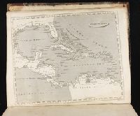
Chart of the West-Indies or the islands of America in the North Sea
Description:
"P. 734, v. 11.", Covers North and South American coastline from Albemarle Sound to the mouth of the Orinoco R., and Includes text and inset of "La Veracruz."
Publisher:
s.n., 1745?]
Subject (Geographic):
Caribbean Area--Maps--Early works to 1800 and West Indies--Maps--Early works to 1800
The description of this slide reflects the way that Erdoes organized 35mm slides. Erdoes arranged his slides in labeled containers that were sub-divided into labeled sections. The title for this image has been transcribed from its sub-section label; images of other slides from the same sub-section share the container title. The date listed here reflects a span of known dates associated the sub-section. In some cases, titles have been expanded to note particular individuals who appear frequently and who were identified by Erdoes in captions. Individual slide captions have not been transcribed or captured during digitization.
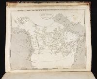
Map showing the communication of the lakes and the rivers between Lake Superior and Slave Lake in North America
Description:
"Gent. Mag. March 1790, Pl. I, p. 197" in upper right hand corner., Mounted on linen. Sheet measures 20.7 x 24.3 cm. Cross Collection no. 178., Prime meridian: London., and Relief shown by hachures.
2nd edition, 1st state, with entirely new plate from 1st edition that now shows all of Florida peninsula with title in cartouche., Below map is letterpress entitled: A compendious account of the British colonies in North America., Lower right corner of map includes Evan's polymetric table of America, with distances, and Thomas Templeman's survey of the size and area of the individual colonies., and Watermark.
Subject (Geographic):
NorthAmerica--Maps--Early works to
Subject (Name):
Jefferys, Thomas, -1771. and Robert Sayer and John Bennett (Firm)