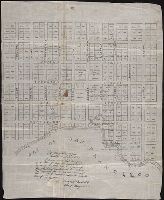
Autograph manuscript map, drawn on cloth, of San Francisco, California, showing streets and numbered lots, some with names of owners indicated.
Description:
Map has been repaired with two pieces of tape or cloth to the left of the inscription., Map has small brown stain in center that can be seen on both the recto and verso., Map was previously folded., The ink of the "I" and "S" in "Francisco" are smudged at the bottom in "Bay of San Francisco"., Verso blank., and Written on the map is a certification of its content signed by Washington A. Bartlett, Chief Magistrate, dated Feb 22, 1847.
Library's copy annotated in black ink on verso, " ... To be given to some public library or institution in England from Thomas O. Larkin of California, February 10th, 1852.", Oriented with north toward lower right., and Shows block and lot numbers, shore line, etc.
Publisher:
Wm. Endicott & Co.,
Subject (Geographic):
SanFrancisco (Calif.)--Maps
Subject (Name):
Ehrenberg, Herman, 1816-1866, Larkin, Thomas Oliver, 1802-1858, and W. Endicott & Co
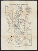
Bai la Trinidad., Bai und Hafen von MonteRey., Bai und Hafen von San Diego., Bai und Hafen von San Francisco., Bai und Hafen von Santa Barbara., Hafen San Pedro., Hafen von la Paz und Bai von Pichilingue., Hafen von San Francisco., and Mündungen der Flüsse Colorado
Description:
"Alfr. Hartmann, architect, entworf.", "Zu Hartmanns zweiten Bericht über Californien.", and Der Hafen San Pedro. Scale [ca. 1:140,000] -- Das Stromgebiet des San Sacramento nebst den Goldlagerstätten. Scale [ca. 1:3,800,000] -- Der Hafen von San Francisco. Scale [ca. 1:168,960] -- Die Bai la Trinidad. Scale [ca. 1:535,000] -- Der Hafen von la Paz und Bai von Pichilingue. Scale [ca. 1:220,000] -- Bai und Hafen von San Francisco. Scale [ca. 1:680,000] -- Bai und Hafen von MonteRey. Scale [ca. 1:300,000] -- Bai und Hafen von Santa Barbara. Scale [ca. 1:515,000] -- Bai und Hafen von San Diego. Scale [ca. 1:330,000] -- Mündungen der Flüsse Colorado und Gila. Scale [ca. 1:510,000].
Publisher:
Verlag und lithographie von B.F. Voigt,
Subject (Geographic):
SanFrancisco Bay (Calif.)--Maps
Subject (Name):
Voigt, Bernard Friedrich, 1787-1859
Subject (Topic):
Harbors--California--Maps, Harbors--Mexico--La Paz (Baja California Sur)--Maps, Naut, Nautical charts--California, Nautical charts--California--Monterey Bay, and Nautical charts--California--San Diego Bay
"Constructed, projected and drawn by Fred D. Stuart, hydrographer, late of the U.S. Ex. Ex.", "Entered according to act of Congress in the 1851 by Cadwalader Ringgold ....", "Sheet no. 1.", Inset view: Entrance to San Francisco., and Place names in English and Spanish.
Publisher:
C.B. Graham, Lithr.,
Subject (Geographic):
SanFrancisco Bay (Calif.)--Maps
Subject (Name):
Blunt, Simon Fraser, d. 1854, Graham, C. B. (Curtis B.), and Stuart, Fred D
"Entered according to act of Congress in the year 1851 by Cadwalader Ringgold ....", "Projected, constructed & drawn by Fred D. Stuart, hydrographer, late of the U.S. Ex. Ex. ; assisted by A.H. Campbell, civil engineer.", "Sheet no. 2.", and Inset views: Mark for invincible buoy, north extreme of Marin Is. on with clump of trees north of San Rafael -- Mark for invincible buoy, Point Smith, east end of Angel I. on with Signal Hill.
Publisher:
C.B. Graham, Lithr.,
Subject (Geographic):
SanFrancisco Bay (Calif.)--Maps
Subject (Name):
Blunt, Simon F, Campbell, Albert H. (Albert Henry), 1826-1899, Graham, C. B. (Curtis B.), and Stuart, Fred D
Subject (Topic):
Nautical charts--California--San Francisco Bay and Nautical charts--California--San Pablo Bay