Search
You Searched For
Search Results
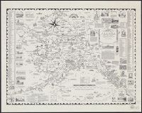
- Creator:
- Chase, Ernest Dudley, 1878-
- Published / Created:
- c1958.
- Call Number:
- 848am 1958
- Container / Volume:
- BRBL_00635
- Image Count:
- 1
- Resource Type:
- Maps, Atlases & Globes
- Found in:
- Beinecke Rare Book and Manuscript Library > A pictorial map of Alaska : the 49th State ... / drawn and published by Ernest Dudley Chase.
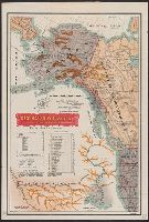
- Creator:
- Helm, Charles J
- Published / Created:
- 1906
- Call Number:
- 848 1906
- Container / Volume:
- BRBL_00630
- Image Count:
- 1
- Resource Type:
- Maps, Atlases & Globes
- Found in:
- Beinecke Rare Book and Manuscript Library > Alaska / compiled from the official records of the General Land Office, U.S. Coast and Geodetic Survey, Geological Survey, Canadian and other sources, under the direction of Frank Bond ; compiled by M. Hendges ; revised and drawn by Charles J. Helm.
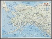
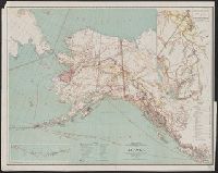
- Creator:
- National Geographic Society (U.S.). Cartographic Division
- Published / Created:
- 1983
- Call Number:
- 848 1983
- Container / Volume:
- BRBL_00631
- Image Count:
- 2
- Resource Type:
- Maps, Atlases & Globes
- Found in:
- Beinecke Rare Book and Manuscript Library > Alaska / produced by the Cartographic Division, National Geographic Society.
- Creator:
- Langrehr, Henry C
- Published / Created:
- 1897
- Call Number:
- 848gfc 1897
- Container / Volume:
- BRBL_00635
- Image Count:
- 2
- Resource Type:
- Maps, Atlases & Globes
- Found in:
- Beinecke Rare Book and Manuscript Library > Alaska and N.W. Territory gold fields from San Francisco.
- Creator:
- United States Coast Survey
- Published / Created:
- 1869
- Call Number:
- 848 1869
- Container / Volume:
- BRBL_00630
- Image Count:
- 1
- Resource Type:
- Maps, Atlases & Globes
- Found in:
- Beinecke Rare Book and Manuscript Library > Alaska and adjoining territory / drawn by H. Lindenkohl.
- Creator:
- Geological Survey (U.S.)
- Published / Created:
- 1898
- Call Number:
- 848 C793 1898
- Container / Volume:
- BRBL_00632
- Image Count:
- 1
- Resource Type:
- Maps, Atlases & Globes
- Found in:
- Beinecke Rare Book and Manuscript Library > Alaska military expedition : in charge of Captain W.R. Abercrombie, U.S.A. Copper River and adjacent territory / topography by P.G. Lowe, F.C. Schrader, and Emil Mahlo.
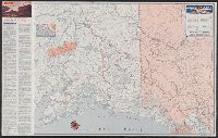
- Creator:
- Northwest Mapping Service
- Published / Created:
- [1949?]
- Call Number:
- 848 1949
- Container / Volume:
- BRBL_00631
- Image Count:
- 2
- Resource Type:
- Maps, Atlases & Globes
- Found in:
- Beinecke Rare Book and Manuscript Library > Alaska road map and travel guide / [prepared for] Union Oil Company of California.
- Creator:
- Anderson Map Company
- Published / Created:
- c1897
- Call Number:
- 848 1897D
- Container / Volume:
- BRBL_00630
- Image Count:
- 1
- Resource Type:
- Maps, Atlases & Globes
- Found in:
- Beinecke Rare Book and Manuscript Library > Anderson's new map of Alaska and Northwest Territory / compiled and published by the O.P. Anderson Map & Blue Print Co., Inc.
- Published / Created:
- Shōwa 18 [1943] and 昭和 18 [1943]
- Call Number:
- 739CBF 1945 2
- Container / Volume:
- BRBL_00391
- Image Count:
- 1
- Resource Type:
- Maps, Atlases & Globes
- Found in:
- Beinecke Rare Book and Manuscript Library > Ankarejji--Datch Hābā / Rikuchi Sokuryōbu, Sanbō Honbu.
- Creator:
- Pierron
- Published / Created:
- [1825?]
- Call Number:
- 848 1825
- Container / Volume:
- BRBL_00630
- Image Count:
- 1
- Resource Type:
- Maps, Atlases & Globes
- Found in:
- Beinecke Rare Book and Manuscript Library > Carte des possessions Russes / dressée par Pierron, d'après la carte de Mr. Brué ; gravé par Le Gagneur ; écrit par Arnoul.
- Published / Created:
- 1939
- Call Number:
- 848 C43 1939
- Container / Volume:
- BRBL_00632
- Image Count:
- 1
- Resource Type:
- Maps, Atlases & Globes
- Found in:
- Beinecke Rare Book and Manuscript Library > Chichagof and vicinity, Alaska.
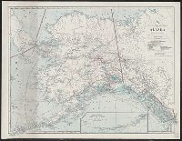
- Creator:
- National Geographic Society (U.S.). Cartographic Division
- Published / Created:
- 1975
- Call Number:
- 848 1975
- Container / Volume:
- BRBL_00631
- Image Count:
- 2
- Resource Type:
- Maps, Atlases & Globes
- Found in:
- Beinecke Rare Book and Manuscript Library > Close-up: U.S.A., Alaska. Produced by the Cartographic Division, National Geographic Society. William T. Peele, chief cartographer, David W. Cook, associate chief cartographer.
- Published / Created:
- 1898?]
- Call Number:
- 848 1898B
- Container / Volume:
- BRBL_00630
- Image Count:
- 1
- Resource Type:
- Maps, Atlases & Globes
- Found in:
- Beinecke Rare Book and Manuscript Library > General chart of Alaska : to accompany reindeer report by Sheldon Jackson general agent of education in Alaska.
- Published / Created:
- 1903
- Call Number:
- 848 1903
- Container / Volume:
- BRBL_00630
- Image Count:
- 1
- Resource Type:
- Maps, Atlases & Globes
- Found in:
- Beinecke Rare Book and Manuscript Library > General chart of Alaska : to accompany reindeer report by Sheldon Jackson general agent of education in Alaska.
- Published / Created:
- Shōwa 18 [1943] and 昭和 18 [1943]
- Call Number:
- 739CBF 1945 1
- Container / Volume:
- BRBL_00391
- Image Count:
- 1
- Resource Type:
- Maps, Atlases & Globes
- Found in:
- Beinecke Rare Book and Manuscript Library > Junō--Shiyatoru / Rikuchi Sokuryōbu, Sanbō Honbu.
- Creator:
- Russia. Gidrograficheskīĭ departament, author
- Call Number:
- 23cea 1858
- Container / Volume:
- BRBL_00021
- Image Count:
- 1
- Resource Type:
- Maps, Atlases & Globes
- Found in:
- Beinecke Rare Book and Manuscript Library > Karta Ledovitago mori︠a︡ i Vostochnago okeana / sostavlena s novi︠e︡ĭshikh opiseĭ v Geograficheskom departamenti︠e︡ Morskago ministerstva.
- Creator:
- Geological Survey (U.S.)
- Published / Created:
- 1909
- Call Number:
- 848 1909
- Container / Volume:
- BRBL_00630
- Image Count:
- 1
- Resource Type:
- Maps, Atlases & Globes
- Found in:
- Beinecke Rare Book and Manuscript Library > Map of Alaska / compiled chiefly from maps of the U.S. Geological Survey ... Alfred H. Brooks, geologist in charge, Division of Alaskan Mineral Resources.
- Published / Created:
- 1920
- Call Number:
- 848gme 1920
- Container / Volume:
- BRBL_00635
- Image Count:
- 1
- Resource Type:
- Maps, Atlases & Globes
- Found in:
- Beinecke Rare Book and Manuscript Library > Map of Alaska / compiled from maps of the U.S. Geological Survey, Alaska Road Commission, and from other data by Alaska Bureau Seattle Chamber of Commerce and Commerical Club 1920.
- Creator:
- Hendges, M
- Published / Created:
- 1898
- Call Number:
- 848 1898J
- Container / Volume:
- BRBL_00630
- Image Count:
- 1
- Resource Type:
- Maps, Atlases & Globes
- Found in:
- Beinecke Rare Book and Manuscript Library > Map of Alaska / compiled from the official records of the General Land Office, U.S. Coast & Geodetic Survey, U.S. Geological Survey, Canadian and other sources, under the direction of Harry King ; compiled and drawn by M. Hendges.
- Creator:
- Geological Survey (U.S.)
- Published / Created:
- 1913
- Call Number:
- 848 1913A
- Container / Volume:
- BRBL_00631
- Image Count:
- 2
- Resource Type:
- Maps, Atlases & Globes
- Found in:
- Beinecke Rare Book and Manuscript Library > Map of Alaska : compiled chiefly from maps of the U.S. Geological Survey / engraved and printed by the U.S. Geological Survey ; Alfred H. Brooks, Geologist in charge, Division of Alaskan Mineral Resources.
- Creator:
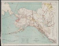
- National Geographic Society (U.S.). Cartographic Division
- Published / Created:
- 1914
- Call Number:
- 848 1914D
- Container / Volume:
- BRBL_00631
- Image Count:
- 1
- Resource Type:
- Maps, Atlases & Globes
- Found in:
- Beinecke Rare Book and Manuscript Library > Map of Alaska : showing latest explorations by U.S. Geological Survey and U.S. Coast and Geodetic Survey.
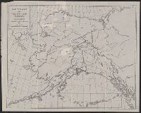
- Published / Created:
- [1936]
- Call Number:
- 848 1936
- Container / Volume:
- BRBL_00631
- Image Count:
- 1
- Resource Type:
- Maps, Atlases & Globes
- Found in:
- Beinecke Rare Book and Manuscript Library > Map of Alaska and western Yukon Territory : showing route of American Museum Palaeontological Expedition, 1936 / D.F. Levett Bradley.
- Creator:
- Geological Survey (U.S.)
- Published / Created:
- 1908
- Call Number:
- 848gbc 1908
- Container / Volume:
- BRBL_00635
- Image Count:
- 1
- Resource Type:
- Maps, Atlases & Globes
- Found in:
- Beinecke Rare Book and Manuscript Library > Map of Alaska showing the known distribution of mineral resources / U.S. Geological Survey, compiled under the direction of Alfred H. Brooks, Geologist in charge of Division of Alaskan Mineral Resources, U.S. Geological Survey.
- Creator:
- Sleem, D. H. (David H.)
- Published / Created:
- c1910.
- Call Number:
- 848 W684 1910
- Container / Volume:
- BRBL_00634
- Image Count:
- 1
- Resource Type:
- Maps, Atlases & Globes
- Found in:
- Beinecke Rare Book and Manuscript Library > Map of Willow Creek Mining District, Cook Inlet Precinct, Alaska / compiled ... by D.H. Sleem.
- Published / Created:
- 1903
- Call Number:
- 848gbc K18 1903
- Container / Volume:
- BRBL_00635
- Image Count:
- 1
- Resource Type:
- Maps, Atlases & Globes
- Found in:
- Beinecke Rare Book and Manuscript Library > Map of the new oil and coal fields [at] Orca, Kayak, Catall, & Yaktag, Alaska / compiled by P.C. Stoess & O.L. Willoughby.
- Published / Created:
- 1914
- Call Number:
- 848gme Sh93 1914
- Container / Volume:
- BRBL_00635
- Image Count:
- 2
- Resource Type:
- Maps, Atlases & Globes
- Found in:
- Beinecke Rare Book and Manuscript Library > Map showing route to Shushanna and Nelchina gold fields ; via Cordova and teh Copper River and Northwestern Railway / issued by the Cordova Chamber of Commerce Jan. 1st 1914.
- Creator:
- Russia. Gidrograficheskīĭ departament, creator
Russia. Гидрографическій департамент
- Published / Created:
- 1858 Ii︠u︡ni︠a︡.
- Call Number:
- 848cea B45 1858
- Container / Volume:
- BRBL_00635
- Image Count:
- 1
- Resource Type:
- Maps, Atlases & Globes
- Found in:
- Beinecke Rare Book and Manuscript Library > Merkatorskai︠a︡ karta Ledovitago i Beringova moreĭ s si︠e︡verozapadnym Berengom Ameriki : ot mysa Lisburna do poluostrova Ali︠a︡ski / sostavlena iz raznykh zhurnalov i kart i gravirovana v Gidrograficheskom departamenti︠e︡ Morskago ministerstva, 1852.
- Published / Created:
- 1860
- Call Number:
- 23 1860
- Container / Volume:
- BRBL_00020
- Image Count:
- 1
- Resource Type:
- Maps, Atlases & Globes
- Found in:
- Beinecke Rare Book and Manuscript Library > Merkatorskai︠a︡ karta [cartographic material] : Rossiĭsko-Amerikanskoĭ Kompanii.
- Creator:
- J.H. Colton & Co
United States. District Court (New York : Southern District)
- Published / Created:
- [1855]
- Call Number:
- 18 1860
- Container / Volume:
- BRBL_00013
- Image Count:
- 1
- Resource Type:
- Maps, Atlases & Globes
- Found in:
- Beinecke Rare Book and Manuscript Library > Northern regions.
- Published / Created:
- [ca. 1920?]
- Call Number:
- 848gb 1920
- Container / Volume:
- BRBL_00635
- Image Count:
- 1
- Resource Type:
- Maps, Atlases & Globes
- Found in:
- Beinecke Rare Book and Manuscript Library > R. L. Polk & Co.'s map of Alaska and Yukon Territory.
- Published / Created:
- 1932
- Call Number:
- 848 D42 1932
- Container / Volume:
- BRBL_00632
- Image Count:
- 1
- Resource Type:
- Maps, Atlases & Globes
- Found in:
- Beinecke Rare Book and Manuscript Library > Reconnaissance topographic map of the Dennison Fork district, Alaska.
- Creator:
- U.S. Coast and Geodetic Survey
- Published / Created:
- 1898
- Call Number:
- 848 J953 1897
- Container / Volume:
- BRBL_00633
- Image Count:
- 1
- Resource Type:
- Maps, Atlases & Globes
- Found in:
- Beinecke Rare Book and Manuscript Library > Route map, Juneau to Porcupine River, Alaska.
- Creator:
- Kroll Map Company, inc
- Published / Created:
- c1927.
- Call Number:
- 848 1927B
- Container / Volume:
- BRBL_00631
- Image Count:
- 2
- Resource Type:
- Maps, Atlases & Globes
- Found in:
- Beinecke Rare Book and Manuscript Library > Standard map of the Territory of Alaska / compiled from latest government surveys land with the assistance of prominent Alaska men.
- Creator:
- National Geographic Society (U.S.). Cartographic Division
- Published / Created:
- 1959
- Call Number:
- 848 1959
- Container / Volume:
- BRBL_00631
- Image Count:
- 1
- Resource Type:
- Maps, Atlases & Globes
- Found in:
- Beinecke Rare Book and Manuscript Library > State of Alaska / compiled and drawn in the Cartographic Division of the National Geographic Society for the National Geographic Magazine.
- Creator:
- Geological Survey (U.S.)
- Published / Created:
- 1898
- Call Number:
- 848gbc 1898A
- Container / Volume:
- BRBL_00635
- Image Count:
- 1
- Resource Type:
- Maps, Atlases & Globes
- Found in:
- Beinecke Rare Book and Manuscript Library > The gold and coal fields of Alaska, together with the principal steamer routes and trails.
- Published / Created:
- 1929
- Call Number:
- 848 C36 1929
- Container / Volume:
- BRBL_00632
- Image Count:
- 1
- Resource Type:
- Maps, Atlases & Globes
- Found in:
- Beinecke Rare Book and Manuscript Library > Topographic map of Chandalar-Sheenjek region, Alaska.
- Published / Created:
- 1899
- Call Number:
- 848 J953 1899
- Container / Volume:
- BRBL_00633
- Image Count:
- 1
- Resource Type:
- Maps, Atlases & Globes
- Found in:
- Beinecke Rare Book and Manuscript Library > [Map showing distances from Juneau, Skagway, and Dyea to various points within Alaska].