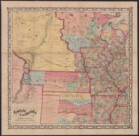
United States. Congress. House. Report ; 23rd Congress, 1st session, 474.
Description:
"This map prepared in the War Dept. by Lieut. Washington Hood"--Wheat, Mapping the transmississippi West, 405., Annotated on verso in ink., Covers lands in the Great Plains., From United States Congress, House Committee on Indian Affairs's Regulating the Indian Department. Washington, D.C.: Gales & Seaton, Print., 1834., In upper left: Rep. 474., Includes text about land that may be granted to the Cherokees., Prime meridian: Washington., Relief shown by hachures and pictorially., and Shows locations of Indian tribes.
Publisher:
Gales & Seaton, Print.,
Subject (Geographic):
Great Plains--Maps
Subject (Name):
Gales & Seaton and United States. Congress. House. Committee on Indian Affairs. Regulating the Indian Department
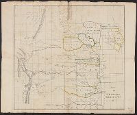
United States. Congress. House. Report ; 23rd Congress, 1st session, 474.
Description:
"This map prepared in the War Dept. by Lieut. Washington Hood"--Wheat, Mapping the transmississippi West, 405., Covers lands in the Great Plains., From United States Congress, House Committee on Indian Affairs's Regulating the Indian Department. Washington, D.C.: Gales & Seaton, Print., 1834., In upper left: Rep. 474., Includes text about land that may be granted to the Cherokees., Prime meridian: Washington., Relief shown by hachures and pictorially., and Shows locations of Indian tribes.
Publisher:
Gales & Seaton, Print.,
Subject (Geographic):
Great Plains--Maps
Subject (Name):
Gales & Seaton and United States. Congress. House. Committee on Indian Affairs. Regulating the Indian Department
Covers lands in the Great Plains., Differs from another version in lacking note about land that may be granted to the Cherokees., In upper left: Rep. 474., Prime meridian: Washington., Relief shown by hachures and pictorially., and Shows locations of Indian tribes.
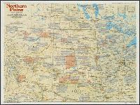
National Geographic Society (U.S.). Cartographic Division
Published / Created:
1986
Call Number:
8101 1986
Container / Volume:
BRBL_00552
Image Count:
2
Resource Type:
Maps, Atlases & Globes
Alternative Title:
Making of America ; no. 13
Description:
"Supplement to the National Geographic, December 1986, page 786A, vol. 170, no. 6.", Includes historical notes and key to abbreviations., Panel title: The making of America, Northern Plains., Relief shown by shading and spot heights., and Text, col. ill., and 5 m
Publisher:
The Society,
Subject (Geographic):
Great Plains--History--Maps, Great Plains--Maps, Middle West--History--Maps, and Middle West--Maps
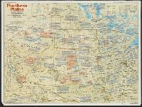