Skip to search
Skip to main content
Skip to first result
Search
You Searched For
Subject (Geographic)
Japan--Maps
New Search
Search Results
Creator:
Published / Created:
c1901.
Call Number:
56 1901A
Container / Volume:
BRBL_00296
Image Count:
2
Resource Type:
Maps, Atlases & Globes
Alternative Title:
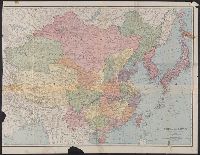
Four-track series., Map of Asia, and New map of Asia and the Chinese empire as they are to-day :
Description:
"Printed for the New York Central's 'Four-Track Series. No. 28'", From panel-title: Issued by the Passenger Department of the New York Central and Hudson River R.R. Copyright 1901 by Geo. H. Daniels General Passenger Agent.", and Recto: advertisements and schedules for trains with text and ill.
Publisher:
Rand, McNally & Co. ,
Subject (Geographic):
China--Maps, Japan--Maps, and Korea--Maps
Subject (Name):
New York Central and Hudson River Railroad Company
Subject (Topic):
Transportation--China--Maps, Transportation--Japan--Maps, and Transportation--Korea--Maps
Found in:
Beinecke Rare Book and Manuscript Library > A new map of the Chinese Empire with Japan and Korea. Map of Asia. / by Rand, McNally & Co.
Creator:
Published / Created:
1945
Call Number:
556 1945A
Container / Volume:
BRBL_00293
Image Count:
1
Resource Type:
Maps, Atlases & Globes
Description:
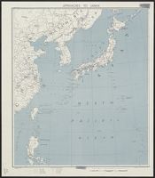
"No. 5581--R & A, OSS.", "Provisional edition.", and Also covers adjoining portions of the U.S.S.R., China and the Philippines.
Publisher:
Reproduction Branch, Office of Strategic Services],
Subject (Geographic):
East Asia--Maps and Japan--Maps
Subject (Name):
United States. Office of Strategic Services. Reproduction Branch
Found in:
Beinecke Rare Book and Manuscript Library > Approaches to Japan.
Creator:
Published / Created:
1904
Call Number:
57 1904
Container / Volume:
BRBL_00302
Image Count:
1
Resource Type:
Maps, Atlases & Globes
Alternative Title:
Charts, etc.
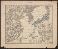
Description:
"No. 2156." and Mounted on linen.
Publisher:
Hydrographic Office,
Subject (Geographic):
China--Maps, Japan--Maps, and Korea--Maps
Found in:
Beinecke Rare Book and Manuscript Library > Asia, Japan and Korea : with the surrounding seas and the adjacent coastal region of China / published at Washington, D.C. Feb. 1904, at the Hydrographic Office. H.M. Hodges, Lieutenant Commander, U.S.N. Hydrographer.
Creator:
Published / Created:
1904
Call Number:
556cea 1904
Container / Volume:
BRBL_00293
Image Count:
1
Resource Type:
Maps, Atlases & Globes
Alternative Title:
Charts, etc.
Description:
"No. 2156." and Mounted on linen.
Publisher:
Hydrographic Office,
Subject (Geographic):
China--Maps, Japan--Maps, and Korea--Maps
Found in:
Beinecke Rare Book and Manuscript Library > Asia, Japan and Korea : with the surrounding seas and the adjacent coastal region of China / published at Washington, D.C. Feb. 1904, at the Hydrographic Office. H.M. Hodges, Lieutenant Commander, U.S.N. Hydrographer.
Published / Created:
1827
Call Number:
57 1827
Container / Volume:
BRBL_00301
Image Count:
1
Resource Type:
Maps, Atlases & Globes
Description:
Inset: Nangasaki ca. 1:70,000.
Subject (Geographic):
Japan--Maps
Found in:
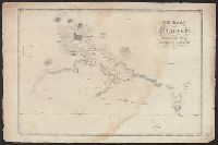
Beinecke Rare Book and Manuscript Library > Carte de L'Empire du Japon ...
Creator:
Published / Created:
1877
Call Number:
56 1877
Container / Volume:
BRBL_00296
Image Count:
1
Resource Type:
Maps, Atlases & Globes
Alternative Title:
China (östlicheTheil), Korea und Japan im Massstab 1:7.500.000
Description:
From Stieler's Hand-Atlas., In upper left: Stieler's Hand Atlas, N⁰ 65., Insets: Schanghai und Umgebung -- Jedo und Umgebung -- Der Canton-Strom und seine Umgebung., Prime meridians: Greenwich, Ferro, Paris., and Relief shown by hachures.
Publisher:
Justus Perthes,
Subject (Geographic):
China--Maps, Japan--Maps, and Korea--Maps
Subject (Name):
Debes, E. (Ernst), 1840-1923
Found in:
Beinecke Rare Book and Manuscript Library > China (östl. Theil), Korea und Japan im Massstab 1:7.500.000 / von A. Petermann ; bearbeitet von Ernst Debes ; gestochen v. H. Eberhardt ; Terrain v. C. Jungmann.
Creator:
Published / Created:
[1912]
Call Number:
56 1912A
Container / Volume:
BRBL_00296
Image Count:
1
Resource Type:
Maps, Atlases & Globes
Alternative Title:
Rand-McNally new library atlas map of China and Japan
Description:
"1-13-'12." and Relief shown by hachures and spot heights.
Publisher:
Rand-McNally,
Subject (Geographic):
China--Maps and Japan--Maps
Found in:
Beinecke Rare Book and Manuscript Library > China and Japan [cartographic material].
Published / Created:
1841
Call Number:
57 1841
Container / Volume:
BRBL_00301
Image Count:
2
Resource Type:
Maps, Atlases & Globes
Subject (Geographic):
Japan--Maps
Found in:
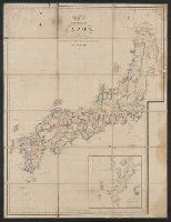
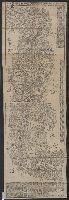
Beinecke Rare Book and Manuscript Library > Dai Nihon Dochu Hayabiki Saiken no Dzu [Guide to Japan].
Published / Created:
1828
Call Number:
57cea N134 1828
Container / Volume:
BRBL_00305
Image Count:
1
Resource Type:
Maps, Atlases & Globes
Subject (Geographic):
Japan--Maps
Found in:
Beinecke Rare Book and Manuscript Library > De Baai van Nagasaki ...
Creator:
Published / Created:
1945
Call Number:
50 1945L
Container / Volume:
BRBL_00273
Image Count:
2
Resource Type:
Maps, Atlases & Globes
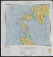
Alternative Title:
AAF cloth chart, AAF cloth chart., Hakodate, and Nemuro
Description:
"Eastern Asia, 1:1,000,000"--Upper left corner., In lower right corner on each side: 5/45 SS., On verso: Eastern Asia 1:1,000,000. AAF cloth chart Nemuro. NK55., and Relief shown by contours and spot heights.
Publisher:
A.M.S.,
Subject (Geographic):
Japan--Maps
Subject (Topic):
Aeronautical charts--Japan
Found in:
Beinecke Rare Book and Manuscript Library > Eastern Asia 1:1,000,000 AAF cloth chart. Hakodate. NK54.
Creator:
Published / Created:
1943
Call Number:
556 1944D
Container / Volume:
BRBL_00293
Image Count:
2
Resource Type:
Maps, Atlases & Globes
Alternative Title:
AAF cloth chart, AAF cloth chart., Hakodate, and Nemuro
Description:
"Eastern Asia, 1:1,000,000"--Upper left corner., On verso: Eastern Asia 1:1,000,000. AAF cloth chart Nemuro. NK55., and Relief shown by contours and spot heights.
Publisher:
A.M.S.,
Subject (Geographic):
Japan--Maps
Subject (Topic):
Aeronautical charts--Japan
Found in:
Beinecke Rare Book and Manuscript Library > Eastern Asia 1:1,000,000 [cartographic material] : AAF cloth chart. Hakodate. NK54.
Published / Created:
1830?]
Call Number:
57 1830
Container / Volume:
BRBL_00301
Image Count:
3
Resource Type:
Maps, Atlases & Globes
Subject (Geographic):
Japan--Maps
Found in:
Beinecke Rare Book and Manuscript Library > Fuji-mi jūsan-shū yochi zenzu [Map of the 13 provinces around Mt. Fuji].
Published / Created:
[1914]
Call Number:
30 1914D
Container / Volume:
BRBL_00032A
Image Count:
1
Resource Type:
Maps, Atlases & Globes
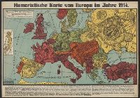
Description:
Caricature map., Ill. of people and animals represent international relations., and Includes inset of Japan and text.
Publisher:
Leutert & Schneidewind,
Subject (Geographic):
Europe--Maps and Japan--Maps
Subject (Topic):
International relations--20th century--Maps, World War, 1914-1918--Caricatures and cartoons, and World War, 1914-1918--Maps
Found in:
Beinecke Rare Book and Manuscript Library > Humoristische karte von Europa im Jahre 1914.
Creator:
Published / Created:
[1904]
Call Number:
556hc 1904
Container / Volume:
BRBL_00294
Image Count:
1
Resource Type:
Maps, Atlases & Globes
Description:
In upper margin: Supplemento Straordinario al N. 15933 (13 febbraio 1904) dato agli abbonati della "Perseveranza"., Relief shown by shading., and Shows railroads.
Publisher:
Antonio Vallardi, editore,
Subject (Geographic):
Japan--Maps and Korea--Maps
Found in:
Beinecke Rare Book and Manuscript Library > Il conflitto Russo-Giappanese : [map of the region].
Creator:
Published / Created:
1912-15.
Call Number:
57 1915
Container / Volume:
BRBL_00302
Image Count:
24
Resource Type:
Maps, Atlases & Globes
Alternative Title:
Topographical map, Division I-V
Description:
Black-and-white maps with water features shown in blue., Each division mapped in 4 to 6 sheets., Imperfect: Division I wanting., Relief shown by contours and spot heights., and Title, place names and legend in English; sheet information and imprint also in Japanese.
Publisher:
Imperial Geological Survey of Japan,
Subject (Geographic):
Japan--Maps
Found in:
Beinecke Rare Book and Manuscript Library > Imperial Geological Survey of Japan topographical map : Division I-[V].
Creator:
Published / Created:
1944
Call Number:
57gmb 1943
Container / Volume:
BRBL_00307
Image Count:
2
Resource Type:
Maps, Atlases & Globes
Alternative Title:
Japan (North) :
Description:
"6-44.", Map of southern Japan showing transportation, water features and populated places., On verso: map of northern Japan, same scale, same features., and Relief shown by hachures and spot heights.
Publisher:
Army Map Service,
Subject (Geographic):
Japan--Maps
Subject (Topic):
Transportation--Japan--Maps
Found in:
Beinecke Rare Book and Manuscript Library > Japan (South) : special strategic map / compiled by the Army Map Service, May 1943.
Creator:
Published / Created:
1945
Call Number:
57gm 1945B
Container / Volume:
BRBL_00306
Image Count:
1
Resource Type:
Maps, Atlases & Globes
Alternative Title:
Japan special strategic map, south, Series (Standard map series designation system) ; 5207., and Series ; 5207
Description:
"Army Map Service, U.S. Army, Washington, D.C. 301605 ... 1943 ... 7-45.", Relief shown by hachures and spot heights., and Shows primary and secondary roads and two types of railroads.
Publisher:
Army Map Service,
Subject (Geographic):
Japan--Maps
Found in:
Beinecke Rare Book and Manuscript Library > Japan (south) special strategic map / prepared under the direction of the Chief of Engineers, U.S. Army, Washington, D.C. Compiled by the Army Map Service.
Creator:
Published / Created:
1809
Call Number:
57 1809
Container / Volume:
BRBL_00301
Image Count:
1
Resource Type:
Maps, Atlases & Globes
Description:
"Pinkerton's modern atlas " appears above border at center of map., Covers also Korea., Number "33" on upper right hand corner., and Relief shown by hachures.
Publisher:
Cadell & Davies,
Subject (Geographic):
Japan--Maps and Korea--Maps
Subject (Name):
Cadell & Davies, Hebert, L, Neele, Samuel John, 1758-1824, and Pinkerton, John, 1758-1826. Modern atlas
Found in:
Beinecke Rare Book and Manuscript Library > Japan / drawn under the direction of Mr. Pinkerton by L. Hebert ; Neele sculpt.
Creator:
Published / Created:
1945
Call Number:
57gfa 1945
Container / Volume:
BRBL_00305
Image Count:
1
Resource Type:
Maps, Atlases & Globes
Description:
"15 January 1945.", "No. 5572-R&A, O.S.S.", Includes glossary and table: Reliability of data., and Inset: Hokkaidō.
Publisher:
OSS,
Subject (Geographic):
Japan--Maps
Subject (Topic):
Waterworks--Japan--Maps
Found in:
Beinecke Rare Book and Manuscript Library > Japan : distribution of waterworks.
Creator:
Published / Created:
1945
Call Number:
57gf 1945
Container / Volume:
BRBL_00305
Image Count:
1
Resource Type:
Maps, Atlases & Globes
Description:
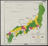
"Degree of industrial concentration ... in 1943.", "No. 8120--R & A, OSS.", "Provisional edition.", and Includes inset of Hokkaido.
Publisher:
Reproduction Branch, Office of Strategic Services],
Subject (Geographic):
Japan--Maps
Subject (Name):
United States. Office of Strategic Services. Reproduction Branch
Subject (Topic):
Industrial concentration--Japan--Maps and Industries--Japan--Maps
Found in:
Beinecke Rare Book and Manuscript Library > Japan : industrial concentration by prefectures.
Branch:v1.62.5 ,Deployed:2024-07-17T14:10:59-04:00