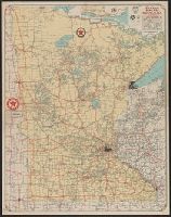
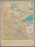
"Texaco road map, 1932, United States," local route maps of Minneapolis-St. Paul and Duluth, distance table, indexes, ill., and text on verso., In lower right: A4 2820., and Includes inset of northeastern Minnesota.
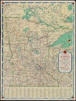
Minnesota official road map and Phillips Petroleum Company 1938 official road map, Minnesota
Description:
In lower left: 438-J.C. 11-L., Includes inset of Fort William area (scale [ca. 1:2,534,400]) and index., and Map of U.S. roads (indexed for national parks and monuments), local route maps of Minneapolis-St.Paul and Duluth, text, and ill. on verso.
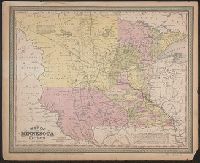
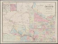
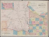
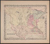
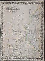
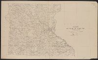
"Entered according to Act of Congress, in the year 1861 by B.M. Smith and A.J. Hill, in the Clerk's Office of the District Court for the District of Minnesota.", Identical to 821 1861 but lacking "Note: Extent of the, and Inset: Outline map of Dakota Territory.
Publisher:
Louis Buechner
Subject (Geographic):
Dakota Territory--Maps, Iowa--Maps, Minnesota--Maps, and Nebraska--Maps
"Entered according to Act of Congress, in the year 1861 by B.M. Smith and A.J. Hill, in the Clerk's Office of the District Court for the District of Minnesota.", "Lith. by Louis Buechner, Saint Paul, Minnesota.", Inset: Outline map of Dakota Territory., and Shows counties and public lands township grid for eastern portion of Dakota Territory and for parts of Minnesota, Nebraska and Iowa, military reservations and outposts, Indian reservations, Indian treaty boundary lines, existing trails and wagon roads, proposed roads, historic routes of exploration, areas of Indian habitation, railroads, cities, and existing and proposed towns.
Publisher:
Louis Buechner
Subject (Geographic):
Dakota Territory--Maps, Iowa--Maps, Minnesota--Maps, and Nebraska--Maps
Subject (Name):
Buechner, Louis and Hill, A. J. (Alfred James), 1823-1895
Subject (Topic):
Cities and towns--Dakota Territory--Maps, Discoveries in geography--Maps, Indian reservations--Dakota Territory--Maps, Indian reservations--Nebraska--Maps, Indians of North America--Maps, and Military bas
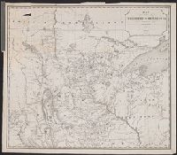
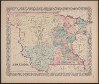
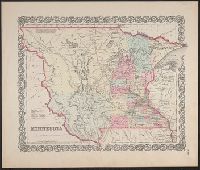
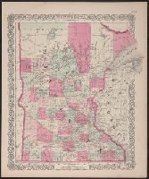
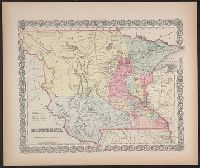
"Entered accoding [sic] to Act of Congress in the year 1855, by J.H. Colton & Co. in ... the Southern District of New York.", Covers Minnesota Territory, extending to White Earth and Missouri rivers to the west., In lower right margin: No. 49., and Includes note.
Publisher:
J. H. Colton & Co.,
Subject (Geographic):
Minnesota--Maps, North Dakota--Maps, and South Dakota--Maps
"Entered according to Act of Congress in the year 1855, by J.H. Colton & Co. ...", Covers Minnesota Territory, including Pembina, and the Yankton, Yanktonnan and Chippewa areas, with Missouri River and White Earth River as western boundary., and In bottom right margin: No. 49.
Publisher:
J.H. Colton & Co.,
Subject (Geographic):
Minnesota--Maps, North Dakota--Maps, and South Dakota--Maps
"Entered according to Act of Congress in the year 1855, by J.H. Colton & Co. ...", Appears in Colton's atlas of the world. New York: J.H. Colton & Co., 1855-56., and Covers Minnesota Territory, including Pembina, and the Yankton, Yanktonnan and Chippewa areas, with Missouri River and White Earth River as western boundary.
Publisher:
J.H. Colton & Co.,
Subject (Geographic):
Minnesota--Maps, North Dakota--Maps, and South Dakota--Maps
Subject (Name):
Colton, G. Woolworth (George Woolworth), 1827-1901. Colton's atlas of the world
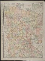
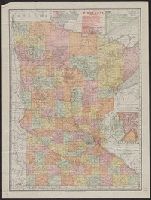
Includes index to railroads, and insets of Cook County and Minneapolis-St. Paul vicinity. and Index to "Counties, creeks, Indian reservations ..." and advertisement on verso.
"Entered according to act of Congress in the year 1864 by J.H. Colton in the clerks office of the district court of the United States for the southern district of New York.", In upper right margin: No. 64., and Text of "Utah and Nevada territories" on verso.
"Entered according to Act of Congress in the year 1855, by J.H. Colton & Co. ...", Accompanied by text: The territory of Minnesota. 1 leaf ; 48 cm., and Covers Minnesota Territory, including Pembina, and the Yankton, Yanktonnan and Chippewa areas, with Missouri River and White Earth River as western boundary.
Publisher:
J.H. Colton & Co.,
Subject (Geographic):
Minnesota--Maps, North Dakota--Maps, and South Dakota--Maps
Minnesota, Shell map of Minnesota, and Shell official road map of Minnesota
Description:
In lower left: 438-J.C. 11-N., Indexed., Road map of United States, local route maps of Minneapolis-St. Paul and Duluth, text, and ill. on verso., and Shell logo at head of title.
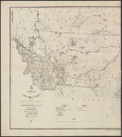
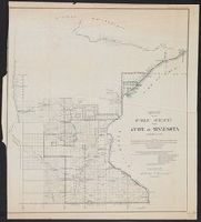
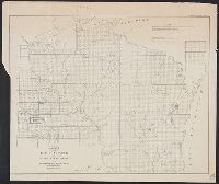
Surveyor General of Iowa, Wisconsin, and Minnesota
Published / Created:
1855
Call Number:
812 1855C
Container / Volume:
BRBL_00555
Image Count:
1
Resource Type:
Maps, Atlases & Globes
Alternative Title:
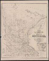
No. 1, Sketch of public surveys in Wisconsin and territory of Minnesota.
Description:
"Surveyor General's Office, Dubuque, October 21st 1855, Warner Lewis.", At head of title: (No. 1)., Blindstamps of Columbia College Library, N, Coordinates not present on map and are approximated., and Sen. Ex. Doc. No. 1, 54th Cong., 1st Sess.
Publisher:
Surveyor General's Office,
Subject (Geographic):
Minnesota--Maps, Minnesota--Surveys--Maps, Wisconsin--Maps, and Wisconsin--Surveys--Maps
Subject (Name):
A. Hoen & Co, Columbia College (New York, N.Y.). Library Stamp, and Lewis, Warner, 1805-1888
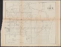
No. 1, Sketch of public surveys in Wisconsin and territory of Minnesota.
Description:
"Surveyor General's Office, Dubuque, October 10th, 1860, Warner Lewis.", At head of title: (No. 1), Includes legend., and Sen. Ex. Doc. No. 1, 2nd Sess. 36th Cong.
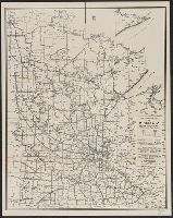
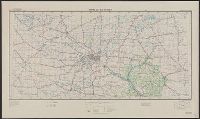
"Work Projects Administration project. Prepared under the direction of the Chief of Engineers, U.S. Army, by Engineer Reproduction Plant, the Army War College.", Coverage includes portions of Minnesota and Wisconsin., and Shows up to 7 classes of roads, 3 classes of railroads, and 4 classes of airfields.
Publisher:
Army Map Service,
Subject (Geographic):
Minnesota--Maps and Wisconsin--Maps
Subject (Name):
United States. Army Map Service and United States. Work Projects Administration
Subject (Topic):
Transportation--Minnesota--Maps and Transportation--Wisconsin--Maps
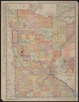
annotated in color pencil; verso index covered by backing., Includes insets of "N.E. corner of Minnesota, showing Cook Co." and "Minneapolis, St. Paul and vicinity.", Indexed on verso., and Shows railroads, counties, townships, etc.