Search
You Searched For
Search Results
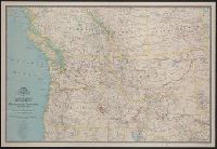
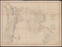
- Creator:
- National Geographic Society (U.S.). Cartographic Section
- Published / Created:
- 1941
- Call Number:
- 80 1941
- Container / Volume:
- BRBL_00536
- Image Count:
- 1
- Resource Type:
- Maps, Atlases & Globes
- Found in:
- Beinecke Rare Book and Manuscript Library > A map of Northwestern United States and neighboring Canadian Provinces / prepared in the Cartographic Section of the National Geographic Society for the National geographic magazine ; James M. Darley, chief cartographer.
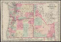
- Creator:
- G.W. & C.B. Colton & Co
- Published / Created:
- 1879
- Call Number:
- 846 1879
- Container / Volume:
- BRBL_00621
- Image Count:
- 1
- Resource Type:
- Maps, Atlases & Globes
- Found in:
- Beinecke Rare Book and Manuscript Library > Colton's Oregon, Washington, and Idaho / G.W. and C.B. Colton & Company.
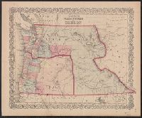
- Creator:
- J.H. Colton & Co
- Published / Created:
- [1853?]
- Call Number:
- 847 1853
- Container / Volume:
- BRBL_00625
- Image Count:
- 1
- Resource Type:
- Maps, Atlases & Globes
- Found in:
- Beinecke Rare Book and Manuscript Library > Colton's Washington and Oregon.
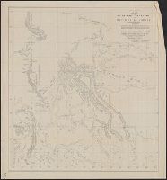
- Creator:
- Thompson, David, 1770-1857
- Published / Created:
- 19--?]
- Call Number:
- 73 1814
- Container / Volume:
- BRBL_00374
- Image Count:
- 1
- Resource Type:
- Maps, Atlases & Globes
- Found in:
- Beinecke Rare Book and Manuscript Library > Copy of a portion of map of the North-West territory of the Province of Canada : from actual survey during the years 1798 to 1812 / by David Thompson.
- Creator:
- Furgerson, Samuel
- Published / Created:
- 1809-1811
- Call Number:
- WA MSS 207
- Image Count:
- 104
- Resource Type:
- Archives or Manuscripts
- Found in:
- Beinecke Rare Book and Manuscript Library > Journal of a voyage from Boston to the North-West Coast of America
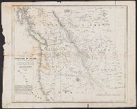
- Creator:
- Parker, Samuel, 1779-1866
- Published / Created:
- 1838
- Call Number:
- 80 1838A
- Container / Volume:
- BRBL_00532
- Image Count:
- 1
- Resource Type:
- Maps, Atlases & Globes
- Found in:
- Beinecke Rare Book and Manuscript Library > Map of Oregon territory / by Samuel Parker.
- Creator:
- Parker, Samuel, 1779-1866
- Published / Created:
- 1838
- Call Number:
- 80 1838A
- Container / Volume:
- BRBL_00532
- Image Count:
- 1
- Resource Type:
- Maps, Atlases & Globes
- Found in:
- Beinecke Rare Book and Manuscript Library > Map of Oregon territory / by Samuel Parker.
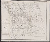
- Creator:
- Wilkes, Charles, 1798-1877
- Published / Created:
- [1845?]
- Call Number:
- 80 1841A
- Container / Volume:
- BRBL_00533
- Image Count:
- 1
- Resource Type:
- Maps, Atlases & Globes
- Found in:
- Beinecke Rare Book and Manuscript Library > Map of the Oregon Territory / by the U.S. Ex. Ex., Charles Wilkes ... Commander, 1841 ; republished by James Wyld.
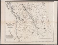
- Creator:
- Wilkes, Charles, 1798-1877
- Published / Created:
- [1845]
- Call Number:
- 80 1841B
- Container / Volume:
- BRBL_00533
- Image Count:
- 1
- Resource Type:
- Maps, Atlases & Globes
- Found in:
- Beinecke Rare Book and Manuscript Library > Map of the Oregon Territory / by the U.S. Ex. Ex., Charles Wilkes, 1841.
- Creator:
- Wyld, James, 1812-1887
- Published / Created:
- April 10th 1845.
- Call Number:
- 846 1845
- Container / Volume:
- BRBL_00620
- Image Count:
- 1
- Resource Type:
- Maps, Atlases & Globes
- Found in:
- Beinecke Rare Book and Manuscript Library > Map of the Oregon districts and the adjacent country / James Wyld, geographer to the Queen.
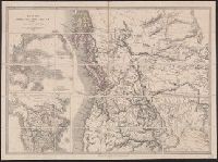
- Creator:
- Hood, Washington
- Published / Created:
- 1838]
- Call Number:
- 80 1838B
- Container / Volume:
- BRBL_00532
- Image Count:
- 1
- Resource Type:
- Maps, Atlases & Globes
- Found in:
- Beinecke Rare Book and Manuscript Library > Map of the United States, Territory of Oregon, west of the Rocky Mountains : exhibiting the various trading depots or forts occupied by the British Hudson Bay Company, connected with the western and northwestern fur trade / compiled in the Bureau of Topog
- Creator:
- United States. Army. Corps of Topographical Engineers
- Published / Created:
- 1859
- Call Number:
- 846 1859
- Container / Volume:
- BRBL_00620
- Image Count:
- 1
- Resource Type:
- Maps, Atlases & Globes
- Found in:
- Beinecke Rare Book and Manuscript Library > Map of the state of Oregon and Washington Territory / compiled in the Bureau of Topogrl. Engrs. chiefly for military purposes, by order of John B. Floyd ; engraved by W.H. Dougal.
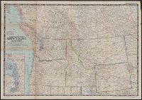
- Creator:
- National Geographic Society (U.S.). Cartographic Division
- Published / Created:
- 1960
- Call Number:
- 845 1960
- Container / Volume:
- BRBL_00620
- Image Count:
- 1
- Resource Type:
- Maps, Atlases & Globes
- Found in:
- Beinecke Rare Book and Manuscript Library > Northwestern United States / compiled and drawn in the Cartographic Division of the National Geographic Society for the National Geographic Magazine.
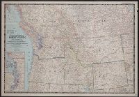
- Creator:
- National Geographic Society (U.S.). Cartographic Section
- Published / Created:
- 1950
- Call Number:
- 845 1950
- Container / Volume:
- BRBL_00620
- Image Count:
- 1
- Resource Type:
- Maps, Atlases & Globes
- Found in:
- Beinecke Rare Book and Manuscript Library > Northwestern United States and neighboring Canadian provinces / compiled and drawn in the Cartographic Section of the National Geographic Society for the National Geographic Magazine ; James M. Darley, chief cartographer.
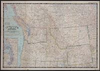
- Creator:
- National Geographic Society (U.S.). Cartographic Section
- Published / Created:
- 1950
- Call Number:
- 80 1950
- Container / Volume:
- BRBL_00536
- Image Count:
- 1
- Resource Type:
- Maps, Atlases & Globes
- Found in:
- Beinecke Rare Book and Manuscript Library > Northwestern United States and neighboring Canadian provinces / compiled and drawn in the Cartographic Section of the National Geographic Society for the National geographic magazine ; James M. Darley, chief cartographer.
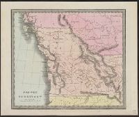
- Creator:
- Illman & Pilbrow
- Published / Created:
- [1836]
- Call Number:
- 845 1833
- Container / Volume:
- BRBL_00620
- Image Count:
- 1
- Resource Type:
- Maps, Atlases & Globes
- Found in:
- Beinecke Rare Book and Manuscript Library > Oregon Territory / Illman & Pilbrow sc.