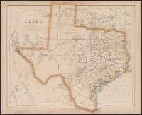
"Entered according to Act of Congress, in the Year 1845, by R.S. Fisher, in the Clerks Office of the District Court of the Southern District of New York.", Includes distances table., and Inset: Plan of the Port of Galveston / made by order of the Mexican govern
Publisher:
R.S. Fisher,
Subject (Geographic):
Galveston Bay (Tex.)--Maps, Texas--Administrative and political divisions--Maps, and Texas--Maps
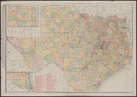
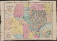
New business atlas map of Texas, New commercial atlas map of Texas, Rand McNally & Co.'s new business atlas map of Texas, and Texas
Description:
Includes insets of the panhandle and southern Texas and indexes., Library's copy annotated in blue pencil and black ink., Relief shown by hachures and spot heights., and Shows counties and railroads.
Publisher:
Rand McNally,
Subject (Geographic):
Texas Panhandle (Tex.)--Maps, Texas--Administrative and political divisions--Maps, and Texas--Maps
"Entered according to act of Congress in the year 1855 by J.H. Colton & Co. in the clerks office of the district court of the United States for the southern district of New York.", "No. 35.", Prime meridians: Greenwich and Washington., Relief, and Shows counties.
Publisher:
J.H. Colton & Co.,
Subject (Geographic):
Texas--Administrative and political divisions--Maps and Texas--Maps
Subject (Name):
Streeter, Thomas W.--(Thomas Winthrop),--1883-1965--Ownership
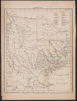
"Entered according to act of Congress in the year 1844 by Sidney E. Morse and Samuel Breese in the clerks office of the southern district of New York.", Prime meridians: Greenwich and Washington., Relief shown by hachures., and Shows counties.
Publisher:
s.n.,
Subject (Geographic):
Texas--Administrative and political divisions--Maps and Texas--Maps
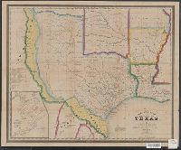
Includes list of counties., Inset: Plan der Galveston Bay., Prime meridians: Ferro and Paris., Relief shown by hachures., and Shows counties, county seats, tracts numbered 1-12 surveyed by Le Grand in 1833, and portions of Indian Territory.
Publisher:
C. Flemming,
Subject (Geographic):
Texas--Administrative and political divisions--Maps and Texas--Maps
"17.", "Atlas of United States &c.", From the authors' Atlas of the United States of North America, Canada ... New Foundland, Mexico, Central America, Cuba, and Jamaica ... 1857., Relief shown by hachures and spot heights., and Shows counties.
Publisher:
John Murray,
Subject (Geographic):
Texas--Administrative and political divisions--Maps and Texas--Maps
Subject (Name):
John Murray (Firm), Johnston, Alexander Keith, 1804-1871, Rogers, Henry D. (Henry Darwin), 1808-1866. Atlas of the United States of North America, Canada ... New Foundland, Mexico, Central America, Cuba, and Jamaica .., and W.
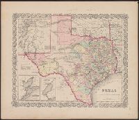
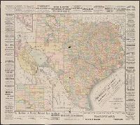
Map showing the proposed route of the Aransas railroad (and its) connections with the eastern roads., New map of the state of Texas, including part of Mexico, Richardsons' new map of Texas, State of Texas, including part of Mexico, and Texas almanac for ...
Description:
"Compiled from government surveys and other authentic documents.", "Engraved expressly for the Texas Almanac.", Includes te, and Inset: Map showing the proposed route of the Aransas railroad (and its) connections with the eastern roads. Scale [ca. 1:19,500,000].
Publisher:
Charles Desilver,
Subject (Geographic):
Mexico, North--Maps, Texas--Administrative and political divisions--Maps, and Texas--Maps
Subject (Name):
Desilver, Charles, Richardson, Willard, 1802-1875, and Wickeland, H
Map showing the proposed route of the Aransas railroad (and its) connections with the eastern roads. and Texas almanac for ...
Description:
"Compiled from government surveys and other authentic documents ... engraved expressly for the Texas almanac.", "Entered according to act of congress in the, Prime meridians: Greenwich and Washington., Relief shown by hachures., and Shows counties and railroads.
Publisher:
Charles Desilver,
Subject (Geographic):
Mexico, North--Maps, Texas--Administrative and political divisions--Maps, and Texas--Maps
Subject (Name):
Desilver, Charles and Richardson, Willard, 1802-1875
New map of the state of Texas, Texas, and Texas almanac for ...
Description:
"Entered according to act of Congress in the year 1866 by G.W. & C.B Colton & Co. in clerks office of the district court of the United States for the southern district of New York.", Prime meridians: Greenwich and Washington., Relief shown by hachures., and Shows counties and railroads.
Publisher:
G.W. & C.B. Colton & Co's Map Establishment,
Subject (Geographic):
Texas Panhandle (Tex.)--Maps, Texas--Administrative and political divisions--Maps, and Texas--Maps
Subject (Name):
G.W. & C.B. Colton & Co and Richardson, Willard, 1802-1875