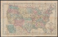
"Entered according to Act of Congress in the year 1856 by Charles Desilver in the clerks office of the District Court of the Eastern District, Also shows proposed western railroad routes., Prime meridians Washington and Greenwich., and Relief shown by hachures.
Publisher:
Charles Desilver,
Subject (Geographic):
United States--Maps
Subject (Name):
Desilver, Charles, Hazzard J. L, and Yeager, E. (Edward)
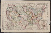
"Entered according to Act of Congress in the year 1859 by Charles Desilver in the clerks office of the District Court of, Also shows battle fields and proposed western railroad routes., Includes decorative border., and Prime meridians: Washington and Greenwich.
Publisher:
Charles Desilver,
Subject (Geographic):
United States--Maps
Subject (Name):
Charles Desilver (Firm), Hazzard, J. L, and Yeager, E. (Edward)
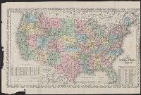
"Entered according to Act of Congress in the year 186[4?] by Charles Desilver in the clerks office of the D, Also shows proposed western railroad routes., Copy 1: Sheet measures 47 x 70 cm., Prime meridians Washington and Greenwich., and Relief shown by hachures.
Publisher:
Charles Desilver,
Subject (Geographic):
United States--Maps
Subject (Name):
Desilver, Charles, Hazzard, J. L, and Yeager, E. (Edward)
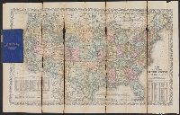
"Entered according to Act of Congress in the year 186[4?] by Charles Desilver in the clerks office of the District Court of the Eastern District of Pe, Includes note and population tables., Prime meridians Washington and Greenwich., and Relief shown by hachures.
Publisher:
Charles Desilver,
Subject (Geographic):
United States--Maps
Subject (Name):
Desilver, Charles, Hazzard, J. L, and Yeager, E. (Edward)
Railroad and military map of the United States, Mexico, the West Indies &c.
Description:
In upper left margin: No. 7. and Insets: Map of the Americas, Africa and a portion of Europe, showing the Atlantic and part of the Pacific oceans -- New Orleans and delta of the Mississippi, Louisiana -- Mobile Harbor, Alabama -- Key West and Tortugas, Florid
Publisher:
J.H. Colton,
Subject (Geographic):
Central America--Maps, Mexico--Maps, United States--Maps, and West Indies--Maps
Subject (Topic):
Military bases--United States--Maps and Railroads--United States--Maps
"Engraved by J.M. Atwood. N.Y.", "Showing the proposed routes to the Pacific Ocean.", Relief shown by hachures., and Shows canals, steamboat lines, finished and unfinished railroads.
Publisher:
J. Disturnell,
Subject (Geographic):
Canada--Maps and United States--Maps
Subject (Name):
Disturnell, John, 1801-1877
Subject (Topic):
Railroads--Canada--Maps and Railroads--United States--Maps
Carl I. Wheat map collection. CU-BANC and New map of the United States and Canada
Description:
Covers southern Canada, including New Brunswick, Prince Edward Island, and Nova Scotia., Inset: Map of Oregon, California, New Mexico & c. [continuation of main map, 1:10,600,000], and Main map extends west to cover most of Montana, Wyoming, Colorado, most of N
Publisher:
Published by J. Disturnell,
Subject (Geographic):
Canada--Maps and United States--Maps
Subject (Name):
Atwood, John M., b. ca. 1818 and Disturnell, John, 1801-1877
Map of the great railroad routes from the Middle Atlantic ports to the Mississippi River., Map of the railroads of New England and eastern N. York., and Map of the United States & Canada
Description:
Includes statistical charts: Population of the United States (by state and territory, 1790-1860) -- Ratio of slaves to total population -- Positions of forts., Insets: Map of the great railroad routes fr, Prime meridian: Greenwich., and Relief shown by hachures.
Publisher:
G.Q. Colton,
Subject (Geographic):
Canada--Maps and United States--Maps
Subject (Topic):
Railroads--New England--Maps, Railroads--New York (State)--Maps, and Railroads--United States--Maps
"12-20'27" and "5410." and Includes inset of "Canadian Pacific Railway and steamship lines."
Publisher:
Poole Bros.,
Subject (Geographic):
Canada--Maps and United States--Maps
Subject (Name):
Canadian Pacific Railway Company, Duluth, South Shore, and Atlantic Railway Company, Duluth, South Shore, and Atlantic Railway Company--Maps, and Spokane International Railway--Maps
Subject (Topic):
Railroads--Canada--Maps and Railroads--United States--Maps
Sportsman's map of Canada and the Northwest Territory.
Description:
Date taken from Yale card catalog indicating map was originally in cover with date of issue, March 1901; also with a cover title, "The sportsman's map of Canada and the Northwest Territory." and Relief shown by hachures.
Publisher:
Poole Bros.,
Subject (Geographic):
Canada--Maps and United States--Maps
Subject (Name):
Canadian Pacific Railway Company, Canadian Pacific Railway Company--Maps, Duluth, South Shore, and Atlantic Railway Company, and Duluth, South Shore, and Atlantic Railway Company--Maps
Subject (Topic):
Railroads--Canada--Maps and Railroads--United States--Maps