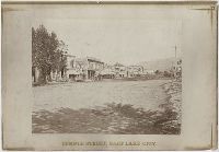
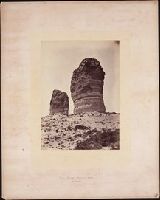
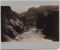
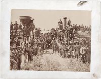
Photographic prints of images created by Andrew Joseph Russell of locations in Utah, Wyoming, California, and Nebraska, ca. 1867-1869. The bound album contains the same images represented in the loose photographic prints. the loose photographic prints were previously bound in a deteriorating leather album with spine title "Views in Salt Lake." The loose photographic prints were foliated before the album was disbound album, Images of locations and structures related to Brigham Young in Utah include views of his residences, known as the Beehive House and Lion House in Salt Lake City; one of these images includes the foundation for the Salt Lake Temple in the foreground. Images of other structures related to Young include his bathhouse located at Warm Sulphur Springs, Salt Lake City, and a view of his cotton and woolen mills in Parley Canyon with the Wasatch Range in the distance, Images of locations in Salt Lake City, Utah, include views of the Tabernacle, the Salt Lake Theatre, Zion's Cooperative Mercantile Institution, and an overview of Temple Street that shows businesses, Images of locations in Echo, Utah, and its vicinity include an overview of the city from the south, as well as several rock formations, including Conglomerate Peaks, Hanging Rock, Sentinel Rock, and Sphinx Rock, Images of locations in Echo Canyon, Utah, and its vicinity include views of several rock outcroppings, including Death's Rock, Finger Rock, and Rock Great Eastern. Several images document Tunnel No. 2 (also known as Echo Tunnel or Wahsatch No. 2) for the Union Pacific Railroad Company, and includes an image of a tunnel entrance, Images of the Weber River and Weber Canyon (also known as the Weber River Valley or Weber Valley), Utah, include views of Coalville; a location on the river near Heneferville (which became Henefer); a vista from Witch Rocks; construction of a wooden bridge across the Weber River at Devil's Gate; a view of Devil's Gate without a bridge; and a view from a ridge of the canyon that shows both entrances to Tunnel No. 3 and two railroad bridges. An image also documents the One Thousand Mile Tree, located in the canyon at a distance one thousand miles west of Omaha, Nebraska, Views of Wilhelmina Pass in Weber Canyon (also known as the Narrows of Weber Canyon), include a distant view of Serrated Rocks (also known as Devil's Slide); a view below a railroad bridge, and an overview of the canyon, Images of locations in the Uinta Mountains, Utah, include a view of Moore's Lake at the head of the Bear River; a view of a man identified as the old trapper in camp beside the Bear River; and a view of the Lake of the Sounding Shore, Images of other locations in Utah include a view of a wooden trestle near Promontory, and a view of Ripple Lake in White Pine Canyon near Park City, Images of locations in the vicinity of Dale Creek, near Sherman and the Laramie Mountains in Wyoming include a view of the Dale Creek Trestle, a wooden railroad trestle bridge; a view of Medicine Bow Mountain; a view of Skull Rock near Sherman Station; a view of Camel Rocks (also known as Granite Rock) near Buford; a view of Devil's Gate in the canyon of Dale Creek; a view of Grizzly Peak from near Evans' Pass; and a view of the source of the Laramie River in the Laramie Mountains, Images of the Green River Valley in Wyoming include a view of the Green River Bridge, a wooden bridge across the Green River with Citadel Rock in the distance; as well as discrete views of rock outcroppings, including Smith's Buttes and Castle Rock, Images of rock outcroppings at various locations throughout Wyoming include views of the High Bluffs near Black Buttes; Church Buttes near Fort Bridger; and Dial Rock in the Laramie Basin, Images of locations in Nebraska include views of a wooden bridge that crosses the North Platte River at its junction with the South Platte River east of the city of North Platte, and a view of the Loup Fork Bridge across Loup Fork of the Platte River, and Images of California include a view from a summit of the Sierra Nevada mountain range with snow sheds in the foreground and Donner Lake in the distance, as well as a view of hydraulic gold mining near Dutch Flat that shows men using jets of water to break down gravel banks
Description:
Title devised by cataloger., Letterpress captions on mounts., Many duplicate images. Some of these photographs also appear in A.J. Russell's The Great West Illustrated . . . New York, 1869., and Accompanied by a box list.
Subject (Geographic):
Utah, Salt Lake City., West (U.S.), Bear River (Utah-Idaho), Buford (Wyo.), California, Coalville (Utah), Dale Creek (Colo. and Wyo.), Donner Lake (Calif.), Dutch Flat (Calif.), Echo (Utah), Echo Canyon (Utah), Green River (Wyo.-Utah), Green River Valley (Wyo.-Utah), Grizzly Peak (Wyo.), Henefer (Utah), Laramie Basin (Wyo.), Laramie Mountains (Colo. and Wyo.), Laramie River (Colo. and Wyo.), Nebraska, North Platte River, One Thousand Mile Tree (Utah : Tree), Parley Canyon (Utah), Platte River (Neb.), Promontory (Utah), Salt Lake City (Utah), Sherman (Wyo.), Sierra Nevada (Calif. and Nev.), Temple Street (Salt Lake City, Utah), Uinta Mountains (Utah and Wyo.), Wasatch Range (Utah and Idaho), Weber River (Utah), Weber River Valley (Utah), White Pine Canyon (Summit County, Utah), Wilhelmina Pass (Utah), Witch Rocks (Utah), and Wyoming
Subject (Name):
Russell, Andrew J., Young, Brigham, 1801-1877, Beehive House (Salt Lake City, Utah), Lion House (Salt Lake City, Utah), Salt Lake Theatre, Tabernacle (Salt Lake City, Utah), Union Pacific Railroad Company, and Zion's Co-operative Mercantile Institution
Subject (Topic):
Homes and haunts, Bridges, Wooden, Hot springs, and Railroads
Photographs of Nevada, Idaho, Wyoming, Arizona, and Utah, including views of the Humbolt Mountains, Pyramid Lake and mining districts in Nevada; Shoshone Falls and the Snake River in Idaho; Twin Bluffs along the Green River in Wyoming; the Grand Canyon in Arizona; and Weber Canyon in Utah
Description:
Accompanied by a box list., Manuscript captions on otherwise plain mounts., and O'Sullivan served as photographer to Clarence King's Exploration of the 40th Parallel (1867-1869, 1872), and to George Wheeler's Expeditions & Surveys West of the 100th Meridian (1871, 1873). Most of these photographs can be matched to those taken for these surveys.
Subject (Geographic):
United States, Arizona, Grand Canyon (Ariz.), Nevada, Idaho, and Wyoming
Subject (Name):
Geographical Surveys West of the 100th Meridian (U.S.) and United States Geological Exploration of the Fortieth Parallel
Photographs of Arizona, New Mexico, Wyoming and Utah, including views of Santa Fe and Laguna and Taos Pueblos in New Mexico; the trolley lines in Uintah, Utah; winter views of the Grand Tetons in Wyoming; and an Ute Indian encampment in Los Pinos, New Mexico and There are also views of bridges and track along the line of the Union Pacific Railroad in Utah, the Atlantic and Pacific Railway Company bridge in Canon Diablo, Arizona, and Toltec Gorge, Arizona, along the line of the Denver & Rio Grand Railway
Description:
Accompanied by a box list. and Letterpress descriptions on verso of some mounts.
Publisher:
W. H. Jackson & Co., or W. H. & E. C. Jackson, Photographers
Subject (Geographic):
New Mexico., Santa Fe (N.M.), New Mexico, Uintah (Utah), Utah, Teton Range (Wyo. and Idaho), and Wyoming
Subject (Name):
Atlantic and Pacific Railway Company., Denver and Rio Grande Railroad Company., Union Pacific Railroad Company., and Chain & Hardy Book, Stationery & Art Co. (Denver, Colo.)
Subject (Topic):
Pueblo Indians, Indians of North America, Ute Indians, and Pueblos
Geological and Geographical Survey of the Territories (U.S.)
Published / Created:
1873.
Call Number:
WA Photos Folio 53
Container / Volume:
Volume (copy 1)
Image Count:
93
Abstract:
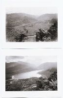
Two versions of a viewbook distributed by the United States Geological and Geographical Survey of the Territories in 1873 with mounted photographic prints created by William Henry Jackson of camps, geothermal features, and landscape primarily in Yellowstone National Park and Montana, 1872, Images of camps established by members of the United States Geological Survey include sites in the Lower Firehole River Basin of Yellowstone National Park; at the mouth of Teton Canyon, Montana; on the shore of Mystic Lake, Gallatin County, Montana; in the Wasatch Mountains near Ogden, Utah; and at Fort Hall, Idaho, Images of geothermal features in the Upper Geyser Basin of Yellowstone National Park include the crater of Old Faithful, the Grand Geyser in eruption, Castle Geyser, and the crater of Grotto Geyser, Images of geothermal features in the Lower Basin of Yellowstone National Park consist of several views of Mammoth Hot Springs on the Gardner River and a view of the calcium carbonate cone known as Cap of Liberty, An image shows the Architectural Geyser in the Lower Firehole River Basin of Yellowstone National Park, Images of rivers in Yellowstone National Park include views along the Yellowstone River consisting of the Upper Falls, the Lower Falls, and the Grand Canyon of the Yellowstone River, as well as a view of Tower Fall, a waterfall on Tower Creek. Several images depict the Yellowstone River Valley, Images of Gallatin County, Montana, include a view of the Needle, a rock pinnacle in Bridger Canyon; views of Mystic Lake; views of the Gallatin River include trails along the river and the walls of Gallatin Canyon, as well as Arched Falls; and views of Mount Blackmore and its vicinity that include views of the mountain and Palace Butte, and Images of mountains in what became Grand Teton National Park, Wyoming, include Grand Teton (referred to as Mount Hayden) and the Teton Range
Description:
Each photograph is accompanied by a guard sheet with descriptive letter-press captions., Photographs on mounts of the United States Geological and Geographical Survey of the Territories., Both volumes have the same contents of photographic prints with variations in the orientation of prints and the binding., and One volume possesses slightly more gilded ornamentation on its boards as well as gilded edges to the individual mounts.
Publisher:
Government Printing Office
Subject (Geographic):
Yellowstone National Park., Blackmore, Mount (Mont.), Bridger Canyon (Mont.), Firehole River (Wyo.), Fort Hall (Idaho : Fort), Gallatin Canyon (Mont.), Gallatin River (Wyo. and Mont.), Grand Teton (Wyo.), Grand Teton National Park (Wyo.), Idaho, Lower Falls of the Yellowstone River (Wyo.), Mammoth Hot Springs (Wyo.), Montana, Teton Range (Wyo. and Idaho), Tower Creek (Wyo.), Upper Falls of the Yellowstone River (Wyo.), Upper Geyser Basin (Wyo.), Utah, Wasatch Range (Utah and Idaho), Wyoming, Yellowstone National Park, Yellowstone River, and Yellowstone River Valley
Subject (Name):
Jackson, William Henry, 1843-1942. and Geological and Geographical Survey of the Territories (U.S.)
Subject (Topic):
Discoveries in geography, American, Rock formations, United States, Discovery and exploration, and Surveys
Geological and Geographical Survey of the Territories (U.S.)
Published / Created:
1873.
Call Number:
WA Photos Folio 53
Container / Volume:
Volume (copy 2)
Image Count:
94
Abstract:
Two versions of a viewbook distributed by the United States Geological and Geographical Survey of the Territories in 1873 with mounted photographic prints created by William Henry Jackson of camps, geothermal features, and landscape primarily in Yellowstone National Park and Montana, 1872, Images of camps established by members of the United States Geological Survey include sites in the Lower Firehole River Basin of Yellowstone National Park; at the mouth of Teton Canyon, Montana; on the shore of Mystic Lake, Gallatin County, Montana; in the Wasatch Mountains near Ogden, Utah; and at Fort Hall, Idaho, Images of geothermal features in the Upper Geyser Basin of Yellowstone National Park include the crater of Old Faithful, the Grand Geyser in eruption, Castle Geyser, and the crater of Grotto Geyser, Images of geothermal features in the Lower Basin of Yellowstone National Park consist of several views of Mammoth Hot Springs on the Gardner River and a view of the calcium carbonate cone known as Cap of Liberty, An image shows the Architectural Geyser in the Lower Firehole River Basin of Yellowstone National Park, Images of rivers in Yellowstone National Park include views along the Yellowstone River consisting of the Upper Falls, the Lower Falls, and the Grand Canyon of the Yellowstone River, as well as a view of Tower Fall, a waterfall on Tower Creek. Several images depict the Yellowstone River Valley, Images of Gallatin County, Montana, include a view of the Needle, a rock pinnacle in Bridger Canyon; views of Mystic Lake; views of the Gallatin River include trails along the river and the walls of Gallatin Canyon, as well as Arched Falls; and views of Mount Blackmore and its vicinity that include views of the mountain and Palace Butte, and Images of mountains in what became Grand Teton National Park, Wyoming, include Grand Teton (referred to as Mount Hayden) and the Teton Range
Description:
Each photograph is accompanied by a guard sheet with descriptive letter-press captions., Photographs on mounts of the United States Geological and Geographical Survey of the Territories., Both volumes have the same contents of photographic prints with variations in the orientation of prints and the binding., and One volume possesses slightly more gilded ornamentation on its boards as well as gilded edges to the individual mounts.
Publisher:
Government Printing Office
Subject (Geographic):
Yellowstone National Park., Blackmore, Mount (Mont.), Bridger Canyon (Mont.), Firehole River (Wyo.), Fort Hall (Idaho : Fort), Gallatin Canyon (Mont.), Gallatin River (Wyo. and Mont.), Grand Teton (Wyo.), Grand Teton National Park (Wyo.), Idaho, Lower Falls of the Yellowstone River (Wyo.), Mammoth Hot Springs (Wyo.), Montana, Teton Range (Wyo. and Idaho), Tower Creek (Wyo.), Upper Falls of the Yellowstone River (Wyo.), Upper Geyser Basin (Wyo.), Utah, Wasatch Range (Utah and Idaho), Wyoming, Yellowstone National Park, Yellowstone River, and Yellowstone River Valley
Subject (Name):
Jackson, William Henry, 1843-1942. and Geological and Geographical Survey of the Territories (U.S.)
Subject (Topic):
Discoveries in geography, American, Rock formations, United States, Discovery and exploration, and Surveys
35 pairs of photographs selected from the 122 sites visited by the Rephotographic Survey Project. The pairs consist of a copy print made from a nineteenth century image, and a print made from the Survey's field negatives
Description:
The Rephotographic Survey Project, which operated between 1977 and 1979, visited the sites of photographs taken in the nineteenth century and rephotographed them. The original landscape, photography from Colorado, Wyoming, Utah, New Mexico, Arizona, Idaho, and Nevada were originally made by William Henry Jackson, Timothy O'Sullivan, John Hillers, Andrew J. Russell, and Alexander Gardner. and Each photograph is labeled with a site number located on the bottom left corner on the back of the print.
Subject (Geographic):
Arizona, Colorado, Idaho, New Mexico, Nevada, Utah, West (U.S.), and Wyoming
Subject (Name):
Bushaw, Gordon., Dingus, Rick, 1951-, Gardner, Alexander, 1821-1882., Hillers, John K., 1843-1925., Jackson, William Henry, 1843-1942., Klett, Mark, 1952-, O'Sullivan, Timothy H., 1840-1882., Russell, Andrew J., and Rephotographic Survey Project.
Subject (Topic):
Landscape photography and Photography in geography