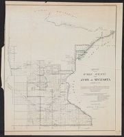
House executive document (United States. Congress. House) ; 38th Congress, 1st session, no. 1.
Description:
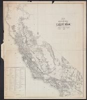
"House R. Ex. Doc. No. 1, 38th Cong., 1st Sess.", Includes "List of private grants finally surveyed.", Relief shown by hachures., and Shows drainage, townships, railroads, mines, oil springs, land grants, etc.
Publisher:
Department of the Interior, General Land Office,
Subject (Geographic):
California--Maps and California--Surveys--Maps
Subject (Name):
Bien, Julius, 1826-1909
Subject (Topic):
Land grants--California--Maps and Mines and mineral resources--California--Maps
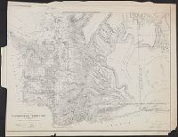
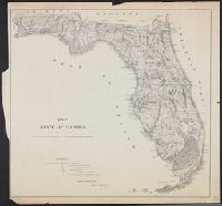
"Sen. Ex. Doc. No. 1, 2d Sess., 36th Cong.", Includes "List of private grants finally surveyed.", Relief shown by hachures., and Shows drainage, townships, land grants, etc.
Also shows mine and mineral resources and Surveyor General and Land Office locations., Colored in outline., Includes notes., Prime meridians: Washington, D.C. and Greenwich., and Relief shown by hachures.
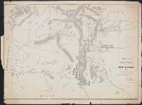
Sen. ex. doc. ; no. 1, 2nd session, 36th Congress and Senate executive document (United States. Congress. Senate) ; 36th Congress, 2nd session, no. 1.
Description:
"Surveyor General's Office, Santa Fe, New Mexico, September 1st, 1860, A.P. Wilbar, Surveyor General of N.M.", Also shows general locations of Indian tribes., Covers lands in New Southwest., and Relief shown by hachures.
Above neat line at right: Sen. ex: doc. no. 1 2d. sess: 36 Cong., Identifies counties with basic surveying grid superimposed over state., Lithographed by: J. Bien, 180 Broadway N.Y., Map approved by Francis L. Dancy, Surveyor General, October 1st, 1860., and Status of surveys identified by symbols.
Publisher:
U.S. Senate,
Subject (Geographic):
Florida--Maps
Subject (Name):
Bien, Julius, 1826-1909
Subject (Topic):
Maps shelf, Real property--Florida--Maps, and Real property--Maps