
You Searched For
« Previous
| 1 - 10 of 21 |
Next »
Search Results


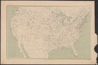
- Creator:
- Geological Survey (U.S.)
- Published / Created:
- 1910
- Call Number:
- 75cbf 1910
- Container / Volume:
- BRBL_00408
- Image Count:
- 1
- Resource Type:
- Maps, Atlases & Globes
- Description:
- Relief shown by contours and gradient tints.
- Publisher:
- USGS,
- Subject (Geographic):
- United States--Maps
- Subject (Name):
- Gannett, Henry, 1846-1914
- Found in:
- Beinecke Rare Book and Manuscript Library > United States relief map / compiled by Henry Gannett.

- Creator:
- Geological Survey (U.S.)
- Published / Created:
- 1906
- Call Number:
- 771cbf Al13 1906
- Image Count:
- 1
- Resource Type:
- Maps, Atlases & Globes
- Description:
- "Henry Gannet, Chief Geographer, H.M. Wilson, Geographer in charge; Topography by Frank Sutton and J.H. Jennings; surveyed in 1891-1892.", "Reprinted Nov. 1906.", "Surveyed in cooperation with the State of New York.", Contour interval 20 feet., and Relief shown by contours.
- Publisher:
- U.S. Geological Survey,
- Subject (Geographic):
- Albany Region (N.Y.)--Maps
- Subject (Name):
- Gannett, Henry, 1846-1914
- Found in:
- Beinecke Rare Book and Manuscript Library > Albany and vicinity, New York.
4.
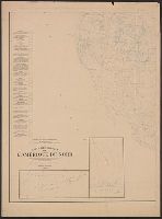
- Published / Created:
- 1906
- Call Number:
- 71 1906A
- Container / Volume:
- BRBL_00371
- Image Count:
- 2
- Resource Type:
- Maps, Atlases & Globes
- Description:
- At head of title: Congrès géologique international Xe session, 1906., Imperfect: Two sheets showing eastern half of map wanting., and Includes 2 insets.
- Publisher:
- s.n.],
- Subject (Name):
- Bailey, Willis, 1858-1949 and Gannett, Henry, 1846-1914
- Subject (Topic):
- Geology--North America--Maps
- Found in:
- Beinecke Rare Book and Manuscript Library > Carte géologique de l'Amérique du nord / dressée d'apres les sources officielles des Etats Unis, du Canada, del la République du Mexique, de la Commission du Chemin de Fer Intercontinental, etc. ; Henry Ganett, géographe ; Bailey Willis, geologue.
- Creator:
- Geological Survey (U.S.)
- Published / Created:
- 1902
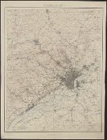
- Call Number:
- 774cbf P53 1908
- Container / Volume:
- BRBL_00501
- Image Count:
- 1
- Resource Type:
- Maps, Atlases & Globes
- Alternative Title:
- Philadelphia and vicinity
- Description:
- "Henry Gannett, Chief Topographer. H.M. Wilson, Chief Geographer in charge. Triangulation by ... and S.S. Gannett. Topography by Geol. Survey of New Jersey, City of Philadelphia, Frank Sutton ... and Robert Muldrow.", "Surveyed in 1894.", and Relief shown by contours and spot heights.
- Publisher:
- U.S. Geological Survey,
- Subject (Geographic):
- Philadelphia Metropolitan Area (Pa.)--Maps
- Subject (Name):
- Gannett, Henry, 1846-1914, Gannett, Samuel S. (Sameul Stinson), 1861-1939, Geological Survey of New Jersey, Muldrow, Robert, Sutton, Frank, and Wilson, Herbert M. (Herbert Michael), 1860-1920
- Found in:
- Beinecke Rare Book and Manuscript Library > Philadelphia and vicinity, Pennsylvania - New Jersey and Delaware.
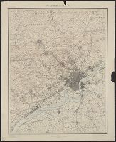
- Creator:
- Geological Survey (U.S.)
- Published / Created:
- 1902
- Call Number:
- 774cbf P53 1908
- Container / Volume:
- BRBL_00501
- Image Count:
- 1
- Resource Type:
- Maps, Atlases & Globes
- Alternative Title:
- Philadelphia and vicinity
- Description:
- "Henry Gannett, Chief Topographer. H.M. Wilson, Chief Geographer in charge. Triangulation by ... and S.S. Gannett. Topography by Geol. Survey of New Jersey, City of Philadelphia, Frank Sutton ... and Robert Muldrow.", "Surveyed in 1894.", and Relief shown by contours and spot heights.
- Publisher:
- U.S. Geological Survey,
- Subject (Geographic):
- Philadelphia Metropolitan Area (Pa.)--Maps
- Subject (Name):
- Gannett, Henry, 1846-1914, Gannett, Samuel S. (Sameul Stinson), 1861-1939, Geological Survey of New Jersey, Muldrow, Robert, Sutton, Frank, and Wilson, Herbert M. (Herbert Michael), 1860-1920
- Found in:
- Beinecke Rare Book and Manuscript Library > Philadelphia and vicinity, Pennsylvania - New Jersey and Delaware.
7.

- Creator:
- Geological Survey (U.S.)
- Published / Created:
- [1900]
- Call Number:
- 847gc T119 1897
- Container / Volume:
- BRBL_00628
- Image Count:
- 1
- Resource Type:
- Maps, Atlases & Globes
- Alternative Title:
- Washington, Tacoma quadrangle :
- Description:
- "Henry Gannett, chief topographer; R.U. Goode, geographer in charge; control by W.T. Griswold and U.S. Coast and Geodetic Survey; topography by G.E. Hyde and R.H. McKee; surveyed in 1894-95." and "Henry Gannett, geographer in charge; land classification by J.W. Rankine and G.H. Plummer; surveyed in 1897."
- Publisher:
- U.S.G.S.,
- Subject (Geographic):
- King County (Wash.)--Maps and Pierce County (Wash.)--Maps
- Subject (Name):
- Gannett, Henry, 1846-1914
- Subject (Topic):
- Forests and forestry--Washington (State)--King County--Maps, Forests and forestry--Washington (State)--Pierce County--Maps, Land use--Washington (State)--King County--Maps, and Land use--Washington (State)--Pierce County--Maps
- Found in:
- Beinecke Rare Book and Manuscript Library > Land classification and density of standing timber, Washington, Tacoma quadrangle / U.S. Geological Survey.

- Creator:
- Geological Survey (U.S.)
- Published / Created:
- [1900]
- Call Number:
- 847gc Se18 1897
- Container / Volume:
- BRBL_00628
- Image Count:
- 1
- Resource Type:
- Maps, Atlases & Globes
- Alternative Title:
- Washington, Seattle quadrangle :
- Description:
- "Henry Gannett, chief topographer; R.U. Goode, geographer in charge; control by W.T. Griswold and R.H. McKee; topography by G.E. Hyde and R.H. McKee; surveyed in 1893-94-95." and "Henry Gannett, geographer in charge; land classification by J.W. Rankine and G.
- Publisher:
- U.S.G.S.,
- Subject (Geographic):
- King County (Wash.)--Maps and Snohomish County (Wash.)--Maps
- Subject (Name):
- Gannett, Henry, 1846-1914
- Subject (Topic):
- Forests and forestry--Washington (State)--King County--Maps, Forests and forestry--Washington (State)--Snohomish County--Maps, Land use--Washington (State)--King County--Maps, and Land use--Washington (State)--Snohomish County
- Found in:
- Beinecke Rare Book and Manuscript Library > Land classification and density of standing timber, Washington, Seattle quadrangle / U.S. Geological Survey.
9.
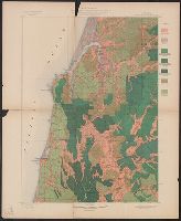
- Creator:
- Geological Survey (U.S.)
- Published / Created:
- [1900]
- Call Number:
- 846gc C786 1896
- Container / Volume:
- BRBL_00623
- Image Count:
- 1
- Resource Type:
- Maps, Atlases & Globes
- Alternative Title:
- Coos Bay quadrangle, Oregon, land classification and density of standing timber.
- Description:
- "Julius Bien & Co. Lith. N.Y.", "Surveyed in 1895-96.", Plate CXXVII from the "Twenty-first annual report" of the United States Geological Survey, Part 5, Forest reserves (1900)., Relief shown by contours and spot heights., and Shows seven classes of land cover.
- Publisher:
- The Survey,
- Subject (Geographic):
- Coos County (Or.)--Maps
- Subject (Name):
- Barnard, E. C. (Edward Chester), 1863-1921, Gannett, Henry, 1846-1914, Geological Survey (U.S.). Annual report, and Johnson, A. J
- Subject (Topic):
- Forests and forestry--Oregon--Coos County--Maps and Land capability for agriculture--Oregon--Coos County--Maps
- Found in:
- Beinecke Rare Book and Manuscript Library > Oregon, Coos Bay quadrangle : land classification and density of standing timber / U.S. Geological Survey ; R.U. Goode, geographer in charge ; triangulation by W.T. Griswold ; topography by E.C. Barnard ; Henry Gannett, geographer in charge ; land classif
- Creator:
- Geological Survey (U.S.)
- Published / Created:
- 1899
- Call Number:
- 75AK 1899
- Container / Volume:
- BRBL_00407A
- Image Count:
- 1
- Resource Type:
- Maps, Atlases & Globes
- Description:
- In upper left border: U.S. Geological Survey, J.W. Powell, director. and Shows rivers, lakes, Indian Reservations, etc. and state boundaries.
- Publisher:
- U.S. Geological Survey,
- Subject (Geographic):
- United States--Maps
- Subject (Name):
- Gannett, Henry, 1846-1914
- Found in:
- Beinecke Rare Book and Manuscript Library > United States base map / compiled by Henry Gannett ; engraved by U.S.G.S.