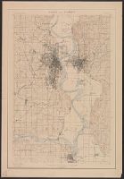
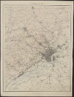
"Henry Gannet, Chief Geographer, H.M. Wilson, Geographer in charge; Topography by Frank Sutton and J.H. Jennings; surveyed in 1891-1892.", "Reprinted Nov. 1906.", "Surveyed in cooperation with the State of New York.", Contour interval 20 feet., and Relief shown by contours.
Douglas, Edward Morehouse, 1855-1932, Gannett, Henry, 1846-1914, Hague, A. (Arnold), 1840-1917, Iddings, Joseph Paxson, 1857-1920, Leffingwell, W. H, Northern Transcontinental Survey, and Rensh
At head of title: Congrès géologique international Xe session, 1906., Imperfect: Two sheets showing eastern half of map wanting., and Includes 2 insets.
Publisher:
s.n.],
Subject (Name):
Bailey, Willis, 1858-1949 and Gannett, Henry, 1846-1914
Geological and Geographical Survey of the Territories (U.S.)
Published / Created:
1879
Call Number:
80cbj 1879
Container / Volume:
BRBL_00537
Image Count:
1
Resource Type:
Maps, Atlases & Globes
Description:
Relief shown by hachures and spot heights.
Publisher:
the Survey,
Subject (Geographic):
Green River Watershed (Wyo.-Utah)--Maps
Subject (Name):
Bechler, G. R, Chittenden, George B, Clark, Fred A, Gannett, Henry, 1846-1914, Hayden, F. V. (Ferdinand Vandeveer), 1829-1887, Julius Bien & Co, and Wilson, A. D. (Allen D.)
Subject (Topic):
Watersheds--Idaho--Maps, Watersheds--Utah--Maps, and Watersheds--Wyoming--Maps
"Henry Gannett, chief topographer; R.U. Goode, geographer in charge; control by W.T. Griswold and R.H. McKee; topography by G.E. Hyde and R.H. McKee; surveyed in 1893-94-95." and "Henry Gannett, geographer in charge; land classification by J.W. Rankine and G.
Publisher:
U.S.G.S.,
Subject (Geographic):
King County (Wash.)--Maps and Snohomish County (Wash.)--Maps
Subject (Name):
Gannett, Henry, 1846-1914
Subject (Topic):
Forests and forestry--Washington (State)--King County--Maps, Forests and forestry--Washington (State)--Snohomish County--Maps, Land use--Washington (State)--King County--Maps, and Land use--Washington (State)--Snohomish County
"Henry Gannett, chief topographer; R.U. Goode, geographer in charge; control by W.T. Griswold and U.S. Coast and Geodetic Survey; topography by G.E. Hyde and R.H. McKee; surveyed in 1894-95." and "Henry Gannett, geographer in charge; land classification by J.W. Rankine and G.H. Plummer; surveyed in 1897."
Publisher:
U.S.G.S.,
Subject (Geographic):
King County (Wash.)--Maps and Pierce County (Wash.)--Maps
Subject (Name):
Gannett, Henry, 1846-1914
Subject (Topic):
Forests and forestry--Washington (State)--King County--Maps, Forests and forestry--Washington (State)--Pierce County--Maps, Land use--Washington (State)--King County--Maps, and Land use--Washington (State)--Pierce County--Maps
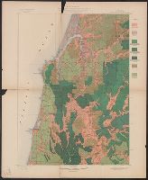
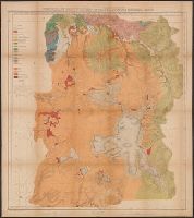
Coos Bay quadrangle, Oregon, land classification and density of standing timber.
Description:
"Julius Bien & Co. Lith. N.Y.", "Surveyed in 1895-96.", Plate CXXVII from the "Twenty-first annual report" of the United States Geological Survey, Part 5, Forest reserves (1900)., Relief shown by contours and spot heights., and Shows seven classes of land cover.
Publisher:
The Survey,
Subject (Geographic):
Coos County (Or.)--Maps
Subject (Name):
Barnard, E. C. (Edward Chester), 1863-1921, Gannett, Henry, 1846-1914, Geological Survey (U.S.). Annual report, and Johnson, A. J
Subject (Topic):
Forests and forestry--Oregon--Coos County--Maps and Land capability for agriculture--Oregon--Coos County--Maps
Geological and Geographical Survey of the Territories (U.S.)
Published / Created:
[1878]
Call Number:
833ca 1878A
Container / Volume:
BRBL_00585
Image Count:
1
Resource Type:
Maps, Atlases & Globes
Description:
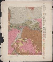
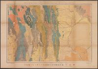
"56"--Lower right margin., "Surveyed in 1877.", Copy 2: Imperfect: brittle and slightly mutilated, with some loss of map., Relief shown by contours and spot heights., Shows geologic formations., and To accompany the Survey's 12th annual report (1878).
Publisher:
Julius Bien, Lith., and The Survey ;
Subject (Geographic):
Idaho--Maps, Topographic, Utah--Maps, Topographic, and Wyoming--Maps, Topographic
Subject (Name):
Gannett, Henry, 1846-1914, Hayden, F. V. (Ferdinand Vandeveer), 1829-1887, and Peale, A. C. (Albert Charles), 1849-1914
Subject (Topic):
Geology--Idaho--Maps, Geology--Utah--Maps, and Geology--Wyoming--Maps
Geological and Geographical Survey of the Territories (U.S.)
Published / Created:
[1877]
Call Number:
833ca 1878AB
Container / Volume:
BRBL_00585
Image Count:
1
Resource Type:
Maps, Atlases & Globes
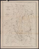
Description:
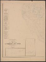
"56" printed in bottom right margin., Backed with linen. Stamp at top "10" crossed out with manuscript "No. 5" below., Relief shown by contours and spot heights., and Shows roads, springs, settlements, etc.
Publisher:
[The Survey],
Subject (Geographic):
Idaho--Maps, Utah--Maps, and Wyoming--Maps
Subject (Name):
Bien, Julius, 1829-1909, Gannett, Henry, 1846-1914, and Hayden, F. V. (Ferdinand Vandeveer), 1829-1887
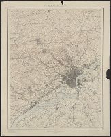
"Henry Gannett, Chief Topographer. H.M. Wilson, Chief Geographer in charge. Triangulation by ... and S.S. Gannett. Topography by Geol. Survey of New Jersey, City of Philadelphia, Frank Sutton ... and Robert Muldrow.", "Surveyed in 1894.", and Relief shown by contours and spot heights.
Publisher:
U.S. Geological Survey,
Subject (Geographic):
Philadelphia Metropolitan Area (Pa.)--Maps
Subject (Name):
Gannett, Henry, 1846-1914, Gannett, Samuel S. (Sameul Stinson), 1861-1939, Geological Survey of New Jersey, Muldrow, Robert, Sutton, Frank, and Wilson, Herbert M. (Herbert Michael), 1860-1920
Geological and Geographical Survey of the Territories (U.S.)
Published / Created:
[1878]
Call Number:
833ca Y38 1878
Container / Volume:
BRBL_00585
Image Count:
1
Resource Type:
Maps, Atlases & Globes
Description:
"Surveyed in 1878.", Includes notes., Relief shown by contours and spot heights. Depths shown by soundings., and To accompany the Survey's 12th annual report (1878).
Publisher:
Julius Bien, Lith., and The Survey ;
Subject (Geographic):
Yellowstone National Park--Maps, Topographic
Subject (Name):
Gannett, Henry, 1846-1914, Hayden, F. V. (Ferdinand Vandeveer), 1829-1887, Holmes, William Henry, 1846-1933, and Wilson, A. D. (Allen D.)
Geological and Geographical Survey of the Territories (U.S.)
Published / Created:
1873?]
Call Number:
834bf 1873A
Container / Volume:
BRBL_00590
Image Count:
1
Resource Type:
Maps, Atlases & Globes
Description:
Relief shown by spot heights.
Publisher:
U.S. Geological and Geographical Survey of the Territories?,
Subject (Name):
Bechler, G. R, Gannett, Henry, 1846-1914, Gardiner, James T. (James Terry), 1842-1912, Hayden, F. V. (Ferdinand Vandeveer), 1829-1887, and Wilson, A. D. (Allen D.)
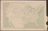
At head of title: Department of the Interior, United States Geological Survey, J.W. Powell, director. and Contour lines drawn at 100, 500, 1000, 1500, 2000, and thence upward at each 1000 feet above sea level.
Publisher:
Engraved by Julius Bien & Co.,
Subject (Geographic):
United States--Maps
Subject (Name):
Gannett, Henry, 1846-1914 and King, Harry, (Harold G. R.)