Search
You Searched For
Search Results
- Creator:
- United States. Department of the Treasury. Bureau of Statistics
- Published / Created:
- [1900]
- Call Number:
- BrSides Double Folio 2019 2
- Image Count:
- 1
- Resource Type:
- Maps, Atlases & Globes
- Found in:
- Beinecke Rare Book and Manuscript Library > Colonial systems of the world / U.S. Treasury Department, Bureau of Statistics ; O.P. Austin, chief of Bureau.
- Published / Created:
- 1898?]
- Call Number:
- 848 1898B
- Container / Volume:
- BRBL_00630
- Image Count:
- 1
- Resource Type:
- Maps, Atlases & Globes
- Found in:
- Beinecke Rare Book and Manuscript Library > General chart of Alaska : to accompany reindeer report by Sheldon Jackson general agent of education in Alaska.
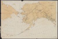
- Creator:
- Geological Survey (U.S.)
- Published / Created:
- 1905?]
- Call Number:
- 847 Y12 1905
- Container / Volume:
- BRBL_00627
- Image Count:
- 1
- Resource Type:
- Maps, Atlases & Globes
- Found in:
- Beinecke Rare Book and Manuscript Library > General map of the Yakima Basin, Washington.
- Creator:
- United States. Adjutant-General's Office. Military Information Division
- Published / Created:
- [1895?]
- Call Number:
- 574 1894
- Container / Volume:
- BRBL_00311
- Image Count:
- 1
- Resource Type:
- Maps, Atlases & Globes
- Found in:
- Beinecke Rare Book and Manuscript Library > Korea or Cho-sen of the Japanese / compiled from the map published by the Japanese War Ministry, Tokio in 1875 and from the latest coast surveys ; names transliterated by Dr. Ernest Satow, Second Secretary & Japanese Secretary to H.M. Legation at Tokio ;
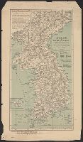
- Creator:
- Hendges, M
- Published / Created:
- 1898
- Call Number:
- 848 1898J
- Container / Volume:
- BRBL_00630
- Image Count:
- 1
- Resource Type:
- Maps, Atlases & Globes
- Found in:
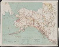
- Beinecke Rare Book and Manuscript Library > Map of Alaska / compiled from the official records of the General Land Office, U.S. Coast & Geodetic Survey, U.S. Geological Survey, Canadian and other sources, under the direction of Harry King ; compiled and drawn by M. Hendges.
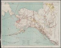
- Creator:
- Hendges, M
- Published / Created:
- 1898
- Call Number:
- 848 1898J
- Container / Volume:
- BRBL_00630
- Image Count:
- 1
- Resource Type:
- Maps, Atlases & Globes
- Found in:
- Beinecke Rare Book and Manuscript Library > Map of Alaska / compiled from the official records of the General Land Office, U.S. Coast & Geodetic Survey, U.S. Geological Survey, Canadian and other sources, under the direction of Harry King ; compiled and drawn by M. Hendges.
- Creator:
- United States. Adjutant-General's Office. Military Information Division
- Published / Created:
- [1898]
- Call Number:
- 855hc 1898A
- Container / Volume:
- BRBL_00765
- Image Count:
- 1
- Resource Type:
- Maps, Atlases & Globes
- Found in:
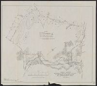
- Beinecke Rare Book and Manuscript Library > Map of Puerto Rico showing line of march of General Schwan's expedition from Ponce and Yauco to crossing of Rio Prieto August 9-15, 1898 / Chas. H. Ourand.
- Creator:
- United States. Adjutant-General's Office. Military Information Division
- Published / Created:
- [1898]
- Call Number:
- 855hc 1898G
- Container / Volume:
- BRBL_00765
- Image Count:
- 1
- Resource Type:
- Maps, Atlases & Globes
- Found in:
- Beinecke Rare Book and Manuscript Library > Map of battle field of August 10th 1898 : between U.S. regular troops under Brig. Genl. Theodore Schwan, U.S. Volunteers and Spanish forces under Col. Julio Soto Villanueva, Alfonso XIII.
- Creator:
- United States. Adjutant-General's Office. Military Information Division
- Published / Created:
- 1900
- Call Number:
- 56 1900
- Container / Volume:
- BRBL_00296
- Image Count:
- 1
- Resource Type:
- Maps, Atlases & Globes
- Found in:
- Beinecke Rare Book and Manuscript Library > Map of north eastern China / prepared in the War Department, Adjutant General's Office, Military Information Division.
- Creator:
- Office of the Engineer Commissioner D.C
- Published / Created:
- 1914
- Call Number:
- 779gmb 1914
- Container / Volume:
- BRBL_00505A
- Image Count:
- 1
- Resource Type:
- Maps, Atlases & Globes
- Found in:
- Beinecke Rare Book and Manuscript Library > Map of the permanent system of highways, District of Columbia / prepared in the Office of the Engineer Commissioner D.C.
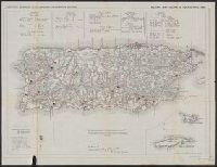
- Creator:
- United States. Adjutant-General's Office. Military Information Division
- Published / Created:
- [1898]
- Call Number:
- 855hc 1898J
- Container / Volume:
- BRBL_00765
- Image Count:
- 1
- Resource Type:
- Maps, Atlases & Globes
- Found in:
- Beinecke Rare Book and Manuscript Library > Military map, island of Puerto Rico, 1898 / drawn by W. Morey Jr. C.E.
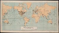
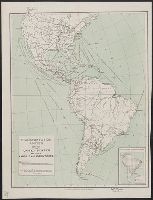
- Creator:
- United States. Department of Commerce and Labor. Bureau of Statistics
- Published / Created:
- [1905?]
- Call Number:
- BrSides Double Folio 2018 91
- Image Count:
- 1
- Resource Type:
- Maps, Atlases & Globes
- Found in:
- Beinecke Rare Book and Manuscript Library > Principal transportation routes of the world.
- Creator:
- United States. Adjutant-General's Office. Military Information Division
- Published / Created:
- [1898]
- Call Number:
- 855hc 1898
- Container / Volume:
- BRBL_00642
- Image Count:
- 1
- Resource Type:
- Maps, Atlases & Globes
- Found in:
- Beinecke Rare Book and Manuscript Library > Sketch map of Guayama and vicinity showing location of Spanish strongholds, and route of March made by Brig. Gen. Hains on Aug 13, 1898.
- Creator:
- United States. Adjutant-General's Office. Military Information Division
- Published / Created:
- [1898]
- Call Number:
- 855hc 1898K
- Container / Volume:
- BRBL_00765
- Image Count:
- 1
- Resource Type:
- Maps, Atlases & Globes
- Found in:
- Beinecke Rare Book and Manuscript Library > Sketch showing movements and positions of troops in the affair of August 9th 1898 at Coamo, Puerto Rico : August 21, 1898, scale 1000' to 1' / Sergt. S.H. Knight, topographer.
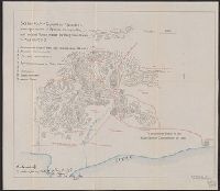
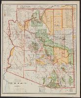
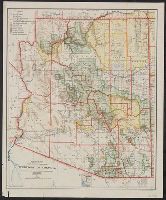
- Creator:
- O'Hare, Daniel
- Published / Created:
- 1906
- Call Number:
- 842 1906
- Container / Volume:
- BRBL_00599
- Image Count:
- 1
- Resource Type:
- Maps, Atlases & Globes
- Found in:
- Beinecke Rare Book and Manuscript Library > Territory of Arizona / compiled from the official records of the General Land Office and other sources under the direction of Frank Bond ; compiled and drawn by Daniel O'Hare.
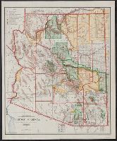
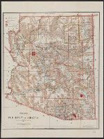
- Creator:
- O'Hare, Daniel
- Published / Created:
- 1907
- Call Number:
- 842 1907A
- Container / Volume:
- BRBL_00599
- Image Count:
- 1
- Resource Type:
- Maps, Atlases & Globes
- Found in:
- Beinecke Rare Book and Manuscript Library > Territory of Arizona / compiled from the official records of the General Land Office and other sources under the direction of I.P. Berthrong ; compiled and drawn by Daniel O'Hare.
- Creator:
- O'Hare, Daniel
- Published / Created:
- 1908
- Call Number:
- 842 1908A
- Container / Volume:
- BRBL_00599
- Image Count:
- 1
- Resource Type:
- Maps, Atlases & Globes
- Found in:
- Beinecke Rare Book and Manuscript Library > Territory of Arizona / compiled from the official records of the General Land Office and other sources under the direction of I.P. Berthrong ; compiled and drawn by Daniel O'Hare.
- Creator:
- United States. General Land Office
- Published / Created:
- 1896
- Call Number:
- 842 1896
- Container / Volume:
- BRBL_00598
- Image Count:
- 1
- Resource Type:
- Maps, Atlases & Globes
- Found in:
- Beinecke Rare Book and Manuscript Library > Territory of Arizona / revised and reconstructed by R.H. Morton ; compiled from the official records of the General Land Office and other sources under supervision of Harry King, C.E. ; lettered by M. Hendges and R.M. Towson.
- Creator:
- United States. Dept. of the Treasury. Bureau of Statistics
- Published / Created:
- [190-?]
- Call Number:
- 70GM 1900
- Container / Volume:
- BRBL_00359
- Image Count:
- 1
- Resource Type:
- Maps, Atlases & Globes
- Found in:
- Beinecke Rare Book and Manuscript Library > Transportation routes between the United States and other American countries / U.S. Treasury Department, Bureau of Statistics ; [B.?] Olszewski.