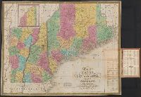
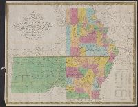
Mitchell, S. Augustus (Samuel Augustus), 1792-1868
Published / Created:
1831
Call Number:
76 1831A
Container / Volume:
BRBL_00444
Image Count:
1
Resource Type:
Maps, Atlases & Globes
Alternative Title:
Maine, New Hampshire & Vermont
Description:
"J.H. Young Sc.", Hand col. Sheet measures 43 x 55.5 cm., Includes statistical table and inset of northern Maine., Prime meridian: Washington., and Relief shown by hachures.
Publisher:
S.A. Mitchell,
Subject (Geographic):
Maine--Maps, New Hampshire--Maps, and Vermont--Maps
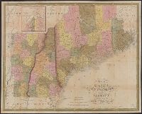
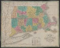
Subject: Map of the states of Massachusetts, Connecticut and Rhode Island, divided into counties, and showing major roads.
Alternative Title:
Massachusetts Connecticut & Rhode Island.
Description:
"Statistical table.", Cover title: Massachusetts Connecticut & Rhode Island., Prime meridian: Washington, D.C. and Greenwich., and Relief shown by hachures and pictorially.
Publisher:
Published by A. Finley Philada,
Subject (Geographic):
Connecticut--Maps., Massachusetts--Maps., and Rhode Island--Maps.
Subject (Name):
Batchelder, Abbie L.--Autograph., Vance, D. H. (David H.), ill, and Young, J. H. (James Hamilton)
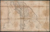
Columbia River, reduced from a survey made by the U.S. Ex. Ex.
Description:
Annotated in color ink to show boundaries, and dissected and mounted on linen., Appears in the author's Narrative of the United States Exploring Expedition ... 1845., Includes inset of "Columbia River, reduced from a survey made by the U.S. Ex. Ex., 1841" and text., and Relief shown by hachures.
Publisher:
J.H. Young : and Sherman & Smith,
Subject (Geographic):
Columbia River--Maps, Northwest, Pacific--Maps, and Oregon--Maps
Subject (Name):
Sherman & Smith, United States Exploring Expedition (1838-1842), and Young, J. H. (James Hamilton)
Columbia River, reduced from a survey made by the U.S. Ex. Ex.
Description:
Appears in the author's Narrative of the United States Exploring Expedition ... 1845., Includes inset of "Columbia River, reduced from a survey made by the U.S. Ex. Ex., 1841" and text., and Relief shown by hachures.
Publisher:
J.H. Young : and Sherman & Smith,
Subject (Geographic):
Columbia River--Maps, Northwest, Pacific--Maps, and Oregon--Maps
Subject (Name):
Sherman & Smith, United States Exploring Expedition (1838-1842), and Young, J. H. (James Hamilton)