Search
You Searched For
Search Results
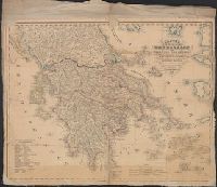
- Published / Created:
- 1842
- Call Number:
- 48 1842
- Container / Volume:
- BRBL_00264
- Image Count:
- 1
- Resource Type:
- Maps, Atlases & Globes
- Found in:
- Beinecke Rare Book and Manuscript Library > [Map of Greece].
- Published / Created:
- 191-.
- Call Number:
- 11hcf 1919D-50
- Image Count:
- 1
- Resource Type:
- Maps, Atlases & Globes
- Found in:
- Beinecke Rare Book and Manuscript Library > [Map of Hungary and vicinity.]
- Published / Created:
- 1918.]
- Call Number:
- 11hcf 1919-47
- Container / Volume:
- BRBL_00010L
- Image Count:
- 1
- Resource Type:
- Maps, Atlases & Globes
- Found in:
- Beinecke Rare Book and Manuscript Library > [Map of Hungary showing nationalities] / geographical data compiled by B. C. Wallis.
- Published / Created:
- 1918.]
- Call Number:
- 11hcf 1919-45
- Container / Volume:
- BRBL_00010L
- Image Count:
- 1
- Resource Type:
- Maps, Atlases & Globes
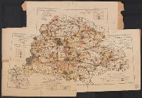
- Found in:
- Beinecke Rare Book and Manuscript Library > [Map of Hungary showing population density ] / geographical data compiled by B. C. Wallis.
- Published / Created:
- 1918.]
- Call Number:
- 11hcf 1919-44
- Container / Volume:
- BRBL_00010L
- Image Count:
- 1
- Resource Type:
- Maps, Atlases & Globes
- Found in:
- Beinecke Rare Book and Manuscript Library > [Map of Hungary showing relief ] / geographical data compiled by B. C. Wallis.
- Published / Created:
- 19--?]
- Call Number:
- 71ED 1850
- Container / Volume:
- BRBL_00371
- Image Count:
- 1
- Resource Type:
- Maps, Atlases & Globes
- Found in:
- Beinecke Rare Book and Manuscript Library > [Map of Indian tribes of North America].
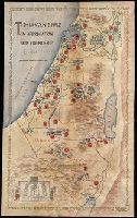
- Creator:
- Paucker, Fred
- Published / Created:
- 1957
- Call Number:
- 51 1957
- Image Count:
- 1
- Resource Type:
- Maps, Atlases & Globes
- Found in:
- Beinecke Rare Book and Manuscript Library > [Map of Israel] / Fred Paucker.
- Published / Created:
- [1917].
- Call Number:
- 11hcf 1919D-28
- Container / Volume:
- BRBL_00010X
- Image Count:
- 2
- Resource Type:
- Maps, Atlases & Globes
- Found in:
- Beinecke Rare Book and Manuscript Library > [Map of Italy and surrounding region during World War I.]
- Published / Created:
- [1833] and 天保 4 年.
- Call Number:
- BrSides 2018 136
- Image Count:
- 1
- Resource Type:
- Maps, Atlases & Globes
- Found in:
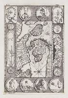
- Beinecke Rare Book and Manuscript Library > [Map of Kyoto] [cartographic material].
- Published / Created:
- [1863?]
- Call Number:
- 57 K99 1834A
- Container / Volume:
- BRBL_00303
- Image Count:
- 1
- Resource Type:
- Maps, Atlases & Globes
- Found in:
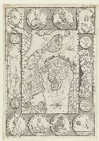
- Beinecke Rare Book and Manuscript Library > [Map of Kyoto].
- Published / Created:
- 1863
- Call Number:
- 57 K99 1834
- Container / Volume:
- BRBL_00303
- Image Count:
- 1
- Resource Type:
- Maps, Atlases & Globes
- Found in:
- Beinecke Rare Book and Manuscript Library > [Map of Kyoto].
- Published / Created:
- [19--?]
- Call Number:
- 32 L84 1900
- Container / Volume:
- BRBL_00051
- Image Count:
- 5
- Resource Type:
- Maps, Atlases & Globes
- Found in:
- Beinecke Rare Book and Manuscript Library > [Map of London and Environs].
- Creator:
- Gibson, J. (John)
- Published / Created:
- 1763]
- Call Number:
- 75 1778
- Collection Title:
- Gentleman's magazine.
- Container / Volume:
- BRBL_00689
- Image Count:
- 1
- Resource Type:
- Maps, Atlases & Globes
- Found in:
- Beinecke Rare Book and Manuscript Library > [Map of Louisiana and the western parts of Virginia and Carolina] / [cartographic material] / J. Gibson, sculp.
- Call Number:
- Zc20 758Le
- Collection Title:
- Histoire de la Louisiane : contenant la decouverte de ce vaste pays ; sa description geographique
- Image Count:
- 1
- Found in:
- Beinecke Rare Book and Manuscript Library > [Map of Louisiana]
- Published / Created:
- 1945?]
- Call Number:
- 283CBF M339 1945A
- Container / Volume:
- BRBL_00026
- Image Count:
- 1
- Resource Type:
- Maps, Atlases & Globes
- Found in:
- Beinecke Rare Book and Manuscript Library > [Map of Marinduque, Philippines, in Japanese.]
- Published / Created:
- 1922]
- Call Number:
- 88cb 1922
- Container / Volume:
- BRBL_00648
- Image Count:
- 1
- Resource Type:
- Maps, Atlases & Globes
- Found in:
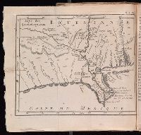
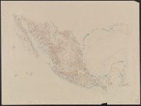
- Beinecke Rare Book and Manuscript Library > [Map of Mexico].
- Published / Created:
- [1830?]
- Call Number:
- 40 M59 1830
- Container / Volume:
- BRBL_00211
- Image Count:
- 1
- Resource Type:
- Maps, Atlases & Globes
- Found in:
- Beinecke Rare Book and Manuscript Library > [Map of Milan.]
- Published / Created:
- 19--.
- Call Number:
- 761 M79 1883
- Container / Volume:
- BRBL_00448
- Image Count:
- 1
- Resource Type:
- Maps, Atlases & Globes
- Found in:
- Beinecke Rare Book and Manuscript Library > [Map of Moosehead Lake and northern Maine, embracing the headwaters of the Penobscot, Kennebec and St. John rivers : specially adapted to the uses of sportsmen and lumbermen / compiled and published by Lucius L. Hubbard].
- Creator:
- Wenng & Wild
Wenng, Ludwig
- Published / Created:
- [ca. 1892]
- Call Number:
- 36 M92 1890A
- Container / Volume:
- BRBL_00125
- Image Count:
- 2
- Resource Type:
- Maps, Atlases & Globes
- Found in:
- Beinecke Rare Book and Manuscript Library > [Map of Munich] / bearbeitet von Ludwig Wenng ; technisches u. kartographisches Institut.
- Published / Created:
- 1885?]
- Call Number:
- 841 1885
- Container / Volume:
- BRBL_00596
- Image Count:
- 1
- Resource Type:
- Maps, Atlases & Globes
- Found in:
- Beinecke Rare Book and Manuscript Library > [Map of New Mexico].
- Published / Created:
- 1945?]
- Call Number:
- 26cbf 1945C
- Container / Volume:
- BRBL_00023A
- Image Count:
- 1
- Resource Type:
- Maps, Atlases & Globes
- Found in:
- Beinecke Rare Book and Manuscript Library > [Map of New South Wales and Tasmania, in Japanese].
- Call Number:
- 1974 +231
- Collection Title:
- A new and elegant general atlas, comprising all the new discoveries, to the present time
- Image Count:
- 1
- Found in:
- Beinecke Rare Book and Manuscript Library > [Map of North America]
- Published / Created:
- 1618?
- Call Number:
- Taylor 278
- Collection Title:
- Jovrnal ou Description dv merveillevx voyage de Gvillavme Schovten, hollandois natif de Hoorn
- Image Count:
- 1
- Found in:
- Beinecke Rare Book and Manuscript Library > [Map of Nova Guinea]
- Published / Created:
- 1914?]
- Call Number:
- 827gme 1914
- Container / Volume:
- BRBL_00578
- Image Count:
- 1
- Resource Type:
- Maps, Atlases & Globes
- Found in:
- Beinecke Rare Book and Manuscript Library > [Map of Oklahoma].
- Published / Created:
- 1912
- Call Number:
- 734 Q31 1912
- Container / Volume:
- BRBL_00380
- Image Count:
- 1
- Resource Type:
- Maps, Atlases & Globes
- Found in:
- Beinecke Rare Book and Manuscript Library > [Map of Québec]
- Published / Created:
- [1915?]
- Call Number:
- 771 Sa24 1915
- Image Count:
- 1
- Resource Type:
- Maps, Atlases & Globes
- Found in:
- Beinecke Rare Book and Manuscript Library > [Map of St. Lawrence County, New York].
- Published / Created:
- [1910?]
- Call Number:
- 823 S25 1910
- Container / Volume:
- BRBL_00568
- Image Count:
- 1
- Resource Type:
- Maps, Atlases & Globes
- Found in:
- Beinecke Rare Book and Manuscript Library > [Map of Stanley and Lyman counties, South Dakota] / S.R. Green, Dep. State Surv., Philip, So. Dak.
- Creator:
- Hogarth, William, 1697-1764, printmaker, artist
- Published / Created:
- [1723]
- Call Number:
- Folio 75 H67 800 v.1 (Oversize)
- Image Count:
- 1
- Resource Type:
- still image
- Found in:
- Lewis Walpole Library > [Map of Stockholm] [graphic]
- Creator:
- Hogarth, William, 1697-1764, printmaker, artist
- Published / Created:
- [1727]
- Call Number:
- Kinnaird 83K(a) Box 120
- Image Count:
- 1
- Resource Type:
- still image
- Found in:
- Lewis Walpole Library > [Map of Stockholm] [graphic]
- Published / Created:
- 191-?]
- Call Number:
- 796gme 1914
- Container / Volume:
- BRBL_00531
- Image Count:
- 1
- Resource Type:
- Maps, Atlases & Globes
- Found in:
- Beinecke Rare Book and Manuscript Library > [Map of Texas showing Frisco lines and connections].
- Published / Created:
- [1872?]
- Call Number:
- BrSides Folio 2018 139
- Image Count:
- 1
- Resource Type:
- Maps, Atlases & Globes
- Found in:
- Beinecke Rare Book and Manuscript Library > [Map of Thunder Bay District, Canada, showing silver lands owned by Peter Mitchell & others, Sept. 7th, 1872].
- Published / Created:
- [1890?].
- Call Number:
- 779 W27 1890
- Container / Volume:
- BRBL_00505A
- Image Count:
- 1
- Resource Type:
- Maps, Atlases & Globes
- Found in:
- Beinecke Rare Book and Manuscript Library > [Map of Washington, D.C.].
- Published / Created:
- 1918
- Call Number:
- 11hc 1918-Z4
- Container / Volume:
- BRBL_00010H
- Image Count:
- 1
- Resource Type:
- Maps, Atlases & Globes
- Found in:
- Beinecke Rare Book and Manuscript Library > [Map of area around Château-Thierry, France.]
- Published / Created:
- 1918
- Call Number:
- 11hc 1918-Z3
- Container / Volume:
- BRBL_00010G
- Image Count:
- 1
- Resource Type:
- Maps, Atlases & Globes
- Found in:
- Beinecke Rare Book and Manuscript Library > [Map of area around Tartiers, France.]
- Published / Created:
- 191-]
- Call Number:
- 11hcf 1919-2
- Container / Volume:
- BRBL_00010J
- Image Count:
- 1
- Resource Type:
- Maps, Atlases & Globes
- Found in:
- Beinecke Rare Book and Manuscript Library > [Map of area in dispute between Belgium and Germany.]
- Published / Created:
- 1919?]
- Call Number:
- 11hcf 1919B-18
- Container / Volume:
- BRBL_00010O
- Image Count:
- 1
- Resource Type:
- Maps, Atlases & Globes
- Found in:
- Beinecke Rare Book and Manuscript Library > [Map of central Europe].
- Published / Created:
- 1919?]
- Call Number:
- 11hcf 1919B-18
- Container / Volume:
- BRBL_00010O
- Image Count:
- 1
- Resource Type:
- Maps, Atlases & Globes
- Found in:
- Beinecke Rare Book and Manuscript Library > [Map of central Europe].
- Published / Created:
- 1919?]
- Call Number:
- 11hcf 1919B-18
- Container / Volume:
- BRBL_00010O
- Image Count:
- 1
- Resource Type:
- Maps, Atlases & Globes
- Found in:
- Beinecke Rare Book and Manuscript Library > [Map of central Europe].
- Creator:
- From the Collection: Stenzel, Franz
- Published / Created:
- n.d.
- Call Number:
- WA MSS S-2368
- Container / Volume:
- Box 7, folder 134
- Image Count:
- 1
- Found in:
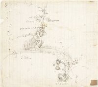
- Beinecke Rare Book and Manuscript Library > Franz R. and Kathryn M. Stenzel collection of western American art (WA MSS S-2368) > Series II: James G. Swan Artwork and Associated Material > > ARTWORK > Works by Swan > Views of Native American Life > [Map of coastal village Alekistet?] Pencil drawing, 19.1 x 22 cm.
- Creator:
- Fries, Lorenz, ca. 1490-1531
- Published / Created:
- 1522?]
- Call Number:
- 66 1522
- Container / Volume:
- BRBL_00347
- Image Count:
- 2
- Resource Type:
- Maps, Atlases & Globes
- Found in:
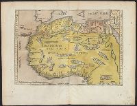
- Beinecke Rare Book and Manuscript Library > [Map of northern Africa].
- Published / Created:
- 1945?]
- Call Number:
- 26cbf 1945D
- Container / Volume:
- BRBL_00023A
- Image Count:
- 1
- Resource Type:
- Maps, Atlases & Globes
- Found in:
- Beinecke Rare Book and Manuscript Library > [Map of northern Australia, in Japanese].
- Published / Created:
- 1945?]
- Call Number:
- 26cbf 1945A
- Container / Volume:
- BRBL_00023A
- Image Count:
- 2
- Resource Type:
- Maps, Atlases & Globes
- Found in:
- Beinecke Rare Book and Manuscript Library > [Map of northern Australia, in Japanese].
- Creator:
- Crépy (Firm)
Fricx, Eugène-Henri, d. 1733
Fricx, Eugène-Henri, d. 1733. Cartes des provinces des Pays Bas
- Published / Created:
- en 1744.
- Call Number:
- 1977 Folio 177
- Image Count:
- 2
- Resource Type:
- Maps, Atlases & Globes
- Found in:
- Beinecke Rare Book and Manuscript Library > [Map of northern Luxembourg and part of Luxembourg province in Belgium] / dresseíe sur les memoires de Eugene Henry Frix.
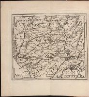
- Published / Created:
- 1884]
- Call Number:
- 32ex Ab97 1884
- Container / Volume:
- BRBL_00075
- Image Count:
- 4
- Resource Type:
- Maps, Atlases & Globes
- Found in:
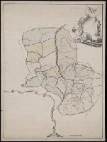
- Beinecke Rare Book and Manuscript Library > [Map of one hundred square miles round Abury; showing the British and Roman Stone and Earthworks of the Downs of North Wilts; by the Rev. A.C. Smith.
- Published / Created:
- 1945?]
- Call Number:
- 284CBF 1945
- Container / Volume:
- BRBL_00026
- Image Count:
- 1
- Resource Type:
- Maps, Atlases & Globes
- Found in:
- Beinecke Rare Book and Manuscript Library > [Map of part of Samar, Philippines, in Japanese.]
- Published / Created:
- [18--?]
- Call Number:
- 796 1836D
- Container / Volume:
- BRBL_00716
- Image Count:
- 1
- Resource Type:
- Maps, Atlases & Globes
- Found in:
- Beinecke Rare Book and Manuscript Library > [Map of parts of Chihuahua, Coahuila and Texas, and New Mexico].
- Published / Created:
- [1816]
- Call Number:
- 40 M59 1816
- Container / Volume:
- BRBL_00210
- Image Count:
- 1
- Resource Type:
- Maps, Atlases & Globes
- Found in:
- Beinecke Rare Book and Manuscript Library > [Map of province of Milan.]
- Published / Created:
- 1893?]
- Call Number:
- 88 M57 1893
- Container / Volume:
- BRBL_00647
- Image Count:
- 1
- Resource Type:
- Maps, Atlases & Globes
- Found in:
- Beinecke Rare Book and Manuscript Library > [Map of railroads in Mexico City Region].
- Published / Created:
- 1915?]
- Call Number:
- 884 1915A
- Container / Volume:
- BRBL_00654
- Image Count:
- 1
- Resource Type:
- Maps, Atlases & Globes
- Found in:
- Beinecke Rare Book and Manuscript Library > [Map of region around Tamiahua Lagoon].
- Published / Created:
- 1922?]
- Call Number:
- 825ad An23 1922
- Container / Volume:
- BRBL_00575
- Image Count:
- 1
- Resource Type:
- Maps, Atlases & Globes
- Found in:
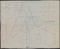
- Beinecke Rare Book and Manuscript Library > [Map of sections in townships 20 S and 21 S, and ranges 19 E and 20 E, Anderson County, Kansas] / F.S.T. 3/25/'22, Garnett, Kas.
- Published / Created:
- [1700?]
- Call Number:
- 53 1700A
- Container / Volume:
- BRBL_00283
- Image Count:
- 1
- Resource Type:
- Maps, Atlases & Globes
- Found in:
- Beinecke Rare Book and Manuscript Library > [Map of southeast Europe and the Black Sea] C. Berey Sculp.
- Creator:
- Rogers, William, b. ca. 1545, engraver
- Published / Created:
- Undated
- Call Number:
- Taylor 216A
- Collection Title:
- Iohn Huighen van Linschoten, his Discours of Voyages into ye Easte & West Indies : deuided into
- Image Count:
- 1
- Found in:
- Beinecke Rare Book and Manuscript Library > [Map of southern Africa and Madagascar]
- Published / Created:
- 191-.
- Call Number:
- 11hcf 1919E-28
- Container / Volume:
- BRBL_00010ZA
- Image Count:
- 1
- Resource Type:
- Maps, Atlases & Globes
- Found in:
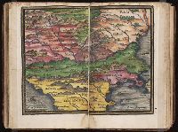
- Beinecke Rare Book and Manuscript Library > [Map of southern Europe and the Adriatic Sea .]
- Published / Created:
- [1725?]
- Call Number:
- 40 1725
- Container / Volume:
- BRBL_00197
- Image Count:
- 2
- Resource Type:
- Maps, Atlases & Globes
- Found in:
- Beinecke Rare Book and Manuscript Library > [Map of southern Italy to Africa and adjacent regions].
- Published / Created:
- Undated
- Call Number:
- 1983 Folio 1
- Collection Title:
- Chertezhnai'a' kniga Sibiri, sostavlennai'a' tobol'skim synom boi'a'rskim Semenom Remezovym v 1701
- Image Count:
- 1
- Resource Type:
- Books, Journals & Pamphlets
- Found in:
- Beinecke Rare Book and Manuscript Library > [Map of southern Siberia]
- Published / Created:
- [1542]
- Call Number:
- Taylor 86
- Collection Title:
- Rvdimenta cosmographica
- Image Count:
- 1
- Found in:
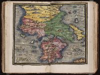
- Beinecke Rare Book and Manuscript Library > [Map of the Balkan Peninsula including Macedonia and Greece]
- Published / Created:
- [1542]
- Call Number:
- Taylor 86
- Collection Title:
- Rvdimenta cosmographica
- Image Count:
- 1
- Found in:
- Beinecke Rare Book and Manuscript Library > [Map of the Balkan Peninsula including Macedonia, Blugaria, Moldova]
- Published / Created:
- 1918
- Call Number:
- 11hcf 1919A-1
- Container / Volume:
- BRBL_00010M
- Image Count:
- 1
- Resource Type:
- Maps, Atlases & Globes
- Found in:
- Beinecke Rare Book and Manuscript Library > [Map of the Balkan Peninsula showing Sofiya and Istambul] : Map used by Clive Day at discussions of Balkan Territorial Committee, April, 1918.
- Published / Created:
- 191-.
- Call Number:
- 11hcf 1919-7
- Container / Volume:
- BRBL_00010M
- Image Count:
- 1
- Resource Type:
- Maps, Atlases & Globes
- Found in:
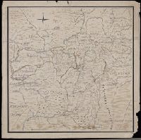
- Beinecke Rare Book and Manuscript Library > [Map of the Caucasus.]
- Creator:
- Loginov, Matveĭ
Логинов, Матвей
- Published / Created:
- [between 1750 and 1800?]
- Call Number:
- BrSides Double Folio 2019 79
- Image Count:
- 1
- Resource Type:
- Maps, Atlases & Globes
- Found in:
- Beinecke Rare Book and Manuscript Library > [Map of the Central and Southern Ural Mountains].
- Published / Created:
- 1838?]
- Call Number:
- 596 1838
- Container / Volume:
- BRBL_00320
- Image Count:
- 2
- Resource Type:
- Maps, Atlases & Globes
- Found in:
- Beinecke Rare Book and Manuscript Library > [Map of the Eastern Frontier of British India, with the adjacent Countries ... By Captain R. Boileau Pemberton, 44th Regt. N.I.].
- Published / Created:
- 1918
- Call Number:
- 2006 2031
- Collection Title:
- La beffa di Buccari : con aggiunti La canzone del Quarnaro, Il catalogo dei trenta di Buccari, Il
- Image Count:
- 1
- Found in:
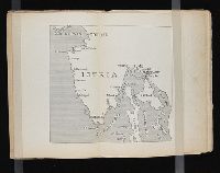
- Beinecke Rare Book and Manuscript Library > [Map of the Istrian penninsula (Croatia)]
- Creator:
- Lewis, Samuel, 1753 or 4-1822
- Call Number:
- 1974 +231
- Collection Title:
- A new and elegant general atlas, comprising all the new discoveries, to the present time
- Image Count:
- 1
- Found in:
- Beinecke Rare Book and Manuscript Library > [Map of the Louisiana Territory]
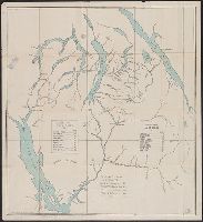
- Published / Created:
- [1848?]
- Call Number:
- Small Manuscript 766 N46 1848
- Image Count:
- 4
- Resource Type:
- Maps, Atlases & Globes
- Found in:
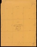
- Beinecke Rare Book and Manuscript Library > [Map of the Nine Squares of New Haven, showing dimensions].
- Published / Created:
- [1780?]
- Call Number:
- BrSides Folio 2019 54
- Image Count:
- 1
- Resource Type:
- Maps, Atlases & Globes
- Found in:
- Beinecke Rare Book and Manuscript Library > [Map of the Perm province].
- Published / Created:
- 19--.
- Call Number:
- 761 R16 1880
- Container / Volume:
- BRBL_00449
- Image Count:
- 1
- Resource Type:
- Maps, Atlases & Globes
- Found in:
- Beinecke Rare Book and Manuscript Library > [Map of the Rangeley Lake District, Maine] / copied from the surveys of Ballard and Perham & co. from a scale of 2 miles to an inch by Osgood Carleton.
- Published / Created:
- 1942?]
- Call Number:
- 352cbf 1942
- Container / Volume:
- BRBL_00109
- Image Count:
- 1
- Resource Type:
- Maps, Atlases & Globes
- Found in:
- Beinecke Rare Book and Manuscript Library > [Map of the Soviet Union].
- Call Number:
- 1974 +231
- Collection Title:
- A new and elegant general atlas, comprising all the new discoveries, to the present time
- Image Count:
- 1
- Found in:
- Beinecke Rare Book and Manuscript Library > [Map of the United States of America]
- Creator:
- Schnierl, Hans Conrad
- Published / Created:
- 1637
- Call Number:
- 1983 Folio 19
- Collection Title:
- [Atlas factice of 96 maps by Blaeu, Visscher, Jansson, Hondius and others]
- Image Count:
- 1
- Found in:
- Beinecke Rare Book and Manuscript Library > [Map of the Valtellina valley in northern Italy]
- Published / Created:
- [1918?]
- Call Number:
- 11hc 1918Y
- Container / Volume:
- BRBL_00010F
- Image Count:
- 2
- Resource Type:
- Maps, Atlases & Globes
- Found in:
- Beinecke Rare Book and Manuscript Library > [Map of the Western Front].
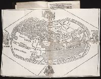
- Published / Created:
- [1685?]
- Call Number:
- 11 1685
- Container / Volume:
- BRBL_00003
- Image Count:
- 1
- Resource Type:
- Maps, Atlases & Globes
- Found in:
- Beinecke Rare Book and Manuscript Library > [Map of the World in Two Hempispheres].
- Creator:
- Coronelli, Vincenzo, 1650-1718
- Published / Created:
- 1696?]
- Call Number:
- 29 1696
- Container / Volume:
- BRBL_00028
- Image Count:
- 2
- Resource Type:
- Maps, Atlases & Globes
- Found in:
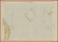
- Beinecke Rare Book and Manuscript Library > [Map of the area of the western Indian Ocean from the southern Arabian Peninsula to the southern tip of India.]
- Published / Created:
- [1903?]
- Call Number:
- 771 N49 1903
- Image Count:
- 1
- Resource Type:
- Maps, Atlases & Globes
- Found in:
- Beinecke Rare Book and Manuscript Library > [Map of the city of New York showing transportation routes].
- Published / Created:
- [between 1790 and 1799?]
- Call Number:
- BrSides Folio 2017 123
- Image Count:
- 1
- Resource Type:
- Maps, Atlases & Globes
- Found in:
- Beinecke Rare Book and Manuscript Library > [Map of the confluence of Saint Marys and Amelia Rivers on the border between Georgia and Florida].
- Published / Created:
- 191-.
- Call Number:
- 11hcf 1919E-1
- Image Count:
- 1
- Resource Type:
- Maps, Atlases & Globes
- Found in:
- Beinecke Rare Book and Manuscript Library > [Map of the countries around the Western Mediterranean.]
- Published / Created:
- [19--?]
- Call Number:
- 40gme 1865
- Container / Volume:
- BRBL_00230
- Image Count:
- 2
- Resource Type:
- Maps, Atlases & Globes
- Found in:
- Beinecke Rare Book and Manuscript Library > [Map of the railways of Italy].
- Published / Created:
- 1618?
- Call Number:
- Taylor 278
- Collection Title:
- Jovrnal ou Description dv merveillevx voyage de Gvillavme Schovten, hollandois natif de Hoorn
- Image Count:
- 1
- Found in:
- Beinecke Rare Book and Manuscript Library > [Map of the world in two hemispheres]
- Published / Created:
- [1509]
- Call Number:
- Taylor 46
- Collection Title:
- Cosmographia Pii Papae in Asiæ & Europæ eleganti descriptione : Asia. Historias rerum vbique
- Image Count:
- 1
- Found in:
- Beinecke Rare Book and Manuscript Library > [Map of the world]
- Creator:
- Qazwīnī, Zakarīyā ibn Muḥammad, 1208 or 9-1283 or 4.
- Published / Created:
- [15--?]
- Call Number:
- Arabic MSS 575
- Image Count:
- 2
- Resource Type:
- Maps, Atlases & Globes
- Found in:
- Beinecke Rare Book and Manuscript Library > [Map of the world] / [Zakarīyā ibn Muḥammad al-Qazwīnī]. -- [15--?].
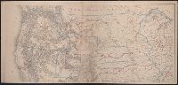
- Published / Created:
- between 1868 and 1889?]
- Call Number:
- 80 1900
- Container / Volume:
- BRBL_00536
- Image Count:
- 2
- Resource Type:
- Maps, Atlases & Globes
- Found in:
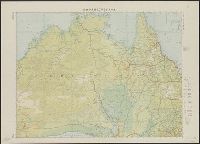
- Beinecke Rare Book and Manuscript Library > [Map of western United States showing military departments].
- Published / Created:
- 1705
- Call Number:
- 1977 +394
- Collection Title:
- Navigantium atque itinerantium bibliotheca: or, A compleat collection of voyages and travels
- Container / Volume:
- Volume 2
- Image Count:
- 1
- Found in:
- Beinecke Rare Book and Manuscript Library > [Map of] Asia
- Published / Created:
- 1739
- Call Number:
- 1975 2757
- Collection Title:
- El atlas abreviado, ò, El nuevo compendio de la geografia universal, politica, historica, i curiosa
- Image Count:
- 1
- Resource Type:
- Maps, Atlases & Globes
- Found in:
- Beinecke Rare Book and Manuscript Library > [Map of] Mogol
- Published / Created:
- An VIII [1800]
- Call Number:
- 1978 +173
- Collection Title:
- Recueil de cartes géographiques, pour la description de l'Indostan; par le Major J. Rennell
- Image Count:
- 1
- Found in:
- Beinecke Rare Book and Manuscript Library > [Map of] Thibet
- Published / Created:
- [1780?]
- Call Number:
- BrSides Double Folio 2019 75
- Image Count:
- 1
- Resource Type:
- Maps, Atlases & Globes
- Found in:
- Beinecke Rare Book and Manuscript Library > [Map showing a part of the Ukraine and Moldova].
- Published / Created:
- 191-.
- Call Number:
- 11hc 1918-Z2
- Container / Volume:
- BRBL_00010G
- Image Count:
- 2
- Resource Type:
- Maps, Atlases & Globes
- Found in:
- Beinecke Rare Book and Manuscript Library > [Map showing area surrounding Coucy, France.]
- Published / Created:
- [1827?]
- Call Number:
- 755 1827
- Container / Volume:
- BRBL_00439
- Image Count:
- 1
- Resource Type:
- Maps, Atlases & Globes
- Found in:
- Beinecke Rare Book and Manuscript Library > [Map showing disputed boundary between U.S. and Canada] Printed at the lithographic Establishment Quarter Master General's Office Horse Guards. Drawn by L. Herbert.
- Published / Created:
- 1899
- Call Number:
- 848 J953 1899
- Container / Volume:
- BRBL_00633
- Image Count:
- 1
- Resource Type:
- Maps, Atlases & Globes
- Found in:
- Beinecke Rare Book and Manuscript Library > [Map showing distances from Juneau, Skagway, and Dyea to various points within Alaska].
- Published / Created:
- [1898]
- Call Number:
- 855hc 1898H
- Container / Volume:
- BRBL_00765
- Image Count:
- 1
- Resource Type:
- Maps, Atlases & Globes
- Found in:
- Beinecke Rare Book and Manuscript Library > [Map showing fortifications around the mouth of the San Juan River, Cuba during the War of 1898.]
- Published / Created:
- 1919
- Call Number:
- 11hcf 1919E-3
- Container / Volume:
- BRBL_00010ZA
- Image Count:
- 1
- Resource Type:
- Maps, Atlases & Globes
- Found in:
- Beinecke Rare Book and Manuscript Library > [Map showing the Trieste-Isonzo region, including Fiume.]
- Published / Created:
- 191-.
- Call Number:
- 11hcf 1919A-13
- Container / Volume:
- BRBL_00010M
- Image Count:
- 1
- Resource Type:
- Maps, Atlases & Globes
- Found in:
- Beinecke Rare Book and Manuscript Library > [Map used discussions of in Rumanian-Yugoslav Committee, regarding Rumanian-Hungarian boundary, March 1919.]
- Published / Created:
- 1802
- Call Number:
- Im B388 Zz802B
- Collection Title:
- The imperial guide : with picturesque plans of the great post roads, containing miniatures
- Image Count:
- 1
- Found in:
- Beinecke Rare Book and Manuscript Library > [Map: Carlisle to Bolton]
- Published / Created:
- 1802
- Call Number:
- Im B388 Zz802B
- Collection Title:
- The imperial guide : with picturesque plans of the great post roads, containing miniatures
- Image Count:
- 1
- Found in:
- Beinecke Rare Book and Manuscript Library > [Map: Coventry to Stony Stratford]
- Published / Created:
- 1920
- Call Number:
- 2006 2042
- Collection Title:
- La questione di Fiume / Alceste de Ambris
- Image Count:
- 1
- Found in:
- Beinecke Rare Book and Manuscript Library > [Map: Il nodo ferroviario di S. Pietro del Carso]
- Published / Created:
- 1920
- Call Number:
- 2006 2042
- Collection Title:
- La questione di Fiume / Alceste de Ambris
- Image Count:
- 1
- Found in:
- Beinecke Rare Book and Manuscript Library > [Map: Il triangolo Fiume-Danzica-Constantinopoli e le linee ferroviarie di accesso al porto di Fiume]
- Published / Created:
- 1802
- Call Number:
- Im B388 Zz802B
- Collection Title:
- The imperial guide : with picturesque plans of the great post roads, containing miniatures
- Image Count:
- 1
- Found in:
- Beinecke Rare Book and Manuscript Library > [Map: Islip to Paddington]
- Published / Created:
- 1920
- Call Number:
- 2006 2042
- Collection Title:
- La questione di Fiume / Alceste de Ambris
- Image Count:
- 1
- Found in:
- Beinecke Rare Book and Manuscript Library > [Map: La linea del compromesso 14 gennaio 1920]
- Published / Created:
- 1920
- Call Number:
- 2006 2042
- Collection Title:
- La questione di Fiume / Alceste de Ambris
- Image Count:
- 1
- Found in:
- Beinecke Rare Book and Manuscript Library > [Map: La linea di Wilson]
- Published / Created:
- 1802
- Call Number:
- Im B388 Zz802B
- Collection Title:
- The imperial guide : with picturesque plans of the great post roads, containing miniatures
- Image Count:
- 1
- Found in:
- Beinecke Rare Book and Manuscript Library > [Map: Lancaster to Worsley]
- Published / Created:
- 1802
- Call Number:
- Im B388 Zz802B
- Collection Title:
- The imperial guide : with picturesque plans of the great post roads, containing miniatures
- Image Count:
- 1
- Found in:
- Beinecke Rare Book and Manuscript Library > [Map: Stafford to Coventry]
- Published / Created:
- 1802
- Call Number:
- Im B388 Zz802B
- Collection Title:
- The imperial guide : with picturesque plans of the great post roads, containing miniatures
- Image Count:
- 1
- Found in:
- Beinecke Rare Book and Manuscript Library > [Map: Talk on the Hill to Birmingham]