Search
You Searched For
Search Results
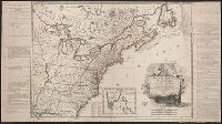
- Call Number:
- Egf 789
- Collection Title:
- The American geography; or, A view of the present situation of the United States of America
- Image Count:
- 1
- Subject (Geographic):
- United States --Maps --Early works to
- Subject (Topic):
- Maps --United States --1788
- Found in:
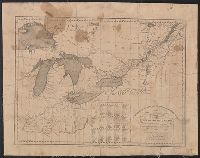
- Beinecke Rare Book and Manuscript Library > A Map of the northern and middle states; comprehending the western Territory and the British dominions in North America. Compiled from the best authorities
- Creator:
- Doolittle, Amos, 1754-1832
Purcell, Joseph
- Published / Created:
- 1788
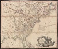
- Call Number:
- Egf 789
- Collection Title:
- The American geography; or, A view of the present situation of the United States of America
- Image Count:
- 1
- Subject (Geographic):
- United States --Maps --Early works to
- Subject (Topic):
- Maps --United States --1788
- Found in:
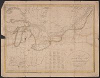
- Beinecke Rare Book and Manuscript Library > A Map of the states of Virginia, North Carolina South Carolina and Georgia comprehending the Spanish provinces of east and west Florida exhibiting the boundaries as fixed by the late Treaty of Peace between the United States and the Spanish dominions comp
- Published / Created:
- 1683?]
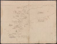
- Call Number:
- 807 1683
- Container / Volume:
- BRBL_00717
- Image Count:
- 2
- Resource Type:
- Maps, Atlases & Globes
- Subject (Geographic):
- United States--Maps, Manuscript--Early
- Found in:
- Beinecke Rare Book and Manuscript Library > [An untitled manuscript map in French depicting the Mississippi River valley from the Gulf of Mexico to the Illinois River in the north and tracing the Wabash and Ohio Rivers in the northeast .]
- Published / Created:
- 1783
- Call Number:
- Cb21 35B
- Collection Title:
- History of the war with America, France, Spain, and Holland; commencing in 1775 and ending in 1783
- Image Count:
- 1
- Subject (Geographic):
- United States --Maps --Early works to
- Found in:
- Beinecke Rare Book and Manuscript Library > A Map of the United States of America, as settled by the peace of 1783
- Creator:
- Lattré, Jean
- Published / Created:
- 1784
- Call Number:
- 75 1784
- Container / Volume:
- BRBL_00396
- Image Count:
- 1
- Resource Type:
- Maps, Atlases & Globes
- Subject (Geographic):
- United States--Maps--Early works to
- Found in:
- Beinecke Rare Book and Manuscript Library > Carte des Etats-Unis de l'Amerique suivant le Traité de Paix de 1783 : dédiée et présentée a s. excellence Mr. Benjamin Franklin... / par son très humble et très obeissant Serviteur Lattré.
- Published / Created:
- 1809
- Call Number:
- 755 1809
- Container / Volume:
- BRBL_00438
- Image Count:
- 1
- Resource Type:
- Maps, Atlases & Globes
- Subject (Geographic):
- United States--Maps
- Found in:
- Beinecke Rare Book and Manuscript Library > The United States of North America : with the British territories and those of Spain.
- Creator:
- United States. Dept. of the Treasury. Bureau of Statistics
- Published / Created:
- [190-?]
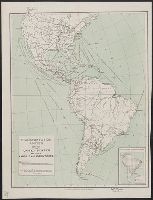
- Call Number:
- 70GM 1900
- Container / Volume:
- BRBL_00359
- Image Count:
- 1
- Resource Type:
- Maps, Atlases & Globes
- Subject (Geographic):
- Railroads--United States--Maps
- Found in:
- Beinecke Rare Book and Manuscript Library > Transportation routes between the United States and other American countries / U.S. Treasury Department, Bureau of Statistics ; [B.?] Olszewski.
- Published / Created:
- 1812
- Call Number:
- 755 1812
- Container / Volume:
- BRBL_00438
- Image Count:
- 1
- Resource Type:
- Maps, Atlases & Globes
- Found in:
- Beinecke Rare Book and Manuscript Library > To the Officers of the Army and the Citizens of the United States This Map of Upper and Lower Canada, and United States contigious Contracted from the Manuscript surveys of P.F. Tardieu, Is respectfully Inscribed by the public's most Obedient Servant Thom
- Published / Created:
- 1812
- Call Number:
- 755 1812B
- Container / Volume:
- BRBL_00438
- Image Count:
- 1
- Resource Type:
- Maps, Atlases & Globes
- Found in:
- Beinecke Rare Book and Manuscript Library > To the Officers of the Army and the Citizens of the United States This Map of Upper and Lower Canada, and United States contigious Contracted from the Mauuscript surveys of P.F. Tardieu, Is respectfully Inscribed by the public's most Obedient Servant Thom
- Creator:
- Russell, John, fl. 1733-1795
- Published / Created:
- 1794 July 26
- Call Number:
- 1986 102
- Collection Title:
- An historical, geographical, commercial, and philosophical view of the American United States, and
- Image Count:
- 1
- Subject (Geographic):
- United States --Maps --Early works to
- Found in:
- Beinecke Rare Book and Manuscript Library > A General map of North America drawn from the best sources
- Published / Created:
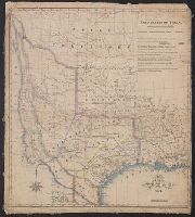
- 1841 [i.e. 1842]
- Call Number:
- 796fab 1842
- Container / Volume:
- BRBL_00530
- Image Count:
- 1
- Resource Type:
- Maps, Atlases & Globes
- Subject (Geographic):
- Texas--Boundaries--United States--Maps
- Found in:
- Beinecke Rare Book and Manuscript Library > A new map of Texas / Day & Haghe, lith.rs to the Queen.
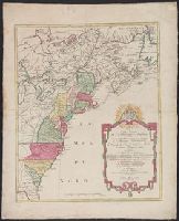
- Call Number:
- Ck44 23
- Collection Title:
- Kort beskrifning om provincien Nya Swerige uti America : som nu foertjden af the Engelske kallas
- Image Count:
- 1
- Subject (Geographic):
- United States --Maps --Early works to
- Found in:
- Beinecke Rare Book and Manuscript Library > Virginiae N. Angliae N. Hollandiae nec non Nova Sueviae delineatio
- Creator:
- L'Isle, Guillaume de, 1675-1726
- Published / Created:
- [1730?]
- Call Number:
- 755 1730
- Container / Volume:
- BRBL_00426
- Image Count:
- 1
- Resource Type:
- Maps, Atlases & Globes
- Subject (Geographic):
- United States--Maps--Early works to
- Found in:
- Beinecke Rare Book and Manuscript Library > Carte de la Louisiane et du cours du Mississipi / dressée sur un grand nombre de memoires entr'autres sur ceux de Mr. le Maire, par Guillme. de L'Isle de l'Academie Rle. des Sciences.
- Creator:
- Lotter, Matthäus Albrecht, 1741-1810
- Published / Created:
- 1776?]
- Call Number:
- 755 1778D
- Container / Volume:
- BRBL_00432
- Image Count:
- 1
- Resource Type:
- Maps, Atlases & Globes
- Subject (Geographic):
- United States--Maps--Early works to
- Found in:
- Beinecke Rare Book and Manuscript Library > Carte nouvelle de l'Amérique angloise contenant tout ce que les Anglois possedent sur le continent de l'Amérique septentrionale savoir le Canada : la Nouvelle Ecosse ou Acadie, les treize provinces unies qui font : les quatres colonies de la Nouvelle An
- Creator:
- Lotter, Matthäus Albrecht, 1741-1810
- Published / Created:
- 1776?]
- Call Number:
- 755 1778
- Container / Volume:
- BRBL_00690
- Image Count:
- 1
- Resource Type:
- Maps, Atlases & Globes
- Subject (Geographic):
- United States--Maps--Early works to
- Found in:
- Beinecke Rare Book and Manuscript Library > Carte nouvelle de l'Amérique angloise contenant tout ce que les Anglois possedent sur le continent de l'Amérique septentrionale savoir le Canada : la Nouvelle Ecosse ou Acadie, les treize provinces unies qui font : les quatres colonies de la Nouvelle An
- Creator:
- Lotter, Matthäus Albrecht, 1741-1810
- Published / Created:
- 1776?]
- Call Number:
- 755 1776E
- Container / Volume:
- BRBL_00430
- Image Count:
- 1
- Resource Type:
- Maps, Atlases & Globes
- Subject (Geographic):
- United States--Maps--Early works to
- Found in:
- Beinecke Rare Book and Manuscript Library > Carte nouvelle de l'Amérique angloise contenant tout ce que les Anglois possedent sur le continent de l'Amérique septentrionale savoir le Canada : la Nouvelle Ecosse ou Acadie, les treize provinces unies qui font : les quatres colonies de la Nouvelle An
- Creator:
- Lotter, Matthäus Albrecht, 1741-1810
- Published / Created:
- 1776?]
- Call Number:
- 71 1776L
- Container / Volume:
- BRBL_00726
- Image Count:
- 1
- Resource Type:
- Maps, Atlases & Globes
- Subject (Geographic):
- United States--Maps--Early works to
- Found in:
- Beinecke Rare Book and Manuscript Library > Carte nouvelle de l'Amérique angloise contenant tout ce que les Anglois possedent sur le continent de l'Amérique septentrionale savoir le Canada : la Nouvelle Ecosse ou Acadie, les treize provinces unies qui font : les quatres colonies de la Nouvelle An