Search
You Searched For
Search Results
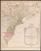
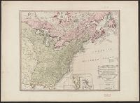
- Creator:
- Lotter, Matthäus Albrecht, 1741-1810.
- Published / Created:
- 1776?]
- Call Number:
- 755 1776E
- Image Count:
- 1
- Resource Type:
- Maps, Atlases & Globes
- Subject (Geographic):
- United States--Maps--Early works to
- Found in:
- Beinecke Rare Book and Manuscript Library > Carte nouvelle de l'Amérique angloise contenant tout ce que les Anglois possedent sur le continent de l'Amérique septentrionale savoir le Canada : la Nouvelle Ecosse ou Acadie, les treize provinces unies qui font : les quatres colonies de la Nouvelle Angleterre ... / gravée exactement d'après les determinations geographiques dernierement faites par Matthieu Albert Lotter.
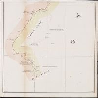
- Creator:
- Lee, Thomas Jefferson, 1808-1891
- Published / Created:
- 1842?]
- Call Number:
- 796fab Sa13 1842H
- Container / Volume:
- BRBL_00530
- Image Count:
- 5
- Resource Type:
- Maps, Atlases & Globes
- Subject (Geographic):
- Texas--Boundaries--United States--Maps
- Found in:
- Beinecke Rare Book and Manuscript Library > Map of the river Sabine from its mouth on the Gulf of Mexico in the sea to Logan's Ferry in latitude 31⁰, 58', 24" north, shewing the boundary between the United States and the Republic of Texas between said points, as marked and laid down by survey in 18
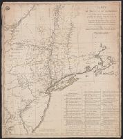
- Creator:
- Capitaine du Chesnoy, Michel, 1746-1804
- Published / Created:
- [1779]
- Call Number:
- 755 1775C
- Container / Volume:
- BRBL_00429
- Image Count:
- 1
- Resource Type:
- Maps, Atlases & Globes
- Subject (Geographic):
- United States--Maps--Early works to
- Found in:
- Beinecke Rare Book and Manuscript Library > Carte du théatre de la guerre dans l'Amerique Septentrionale pendant les années 1775, 76, 77, et 78 [cartographic material] : où se trouvent les principaux camps avec les différentes places et epoques des batailles qui se sont données pendent ces cam
- Creator:
- Russell, John, fl. 1733-1795
- Published / Created:
- 1795 February 7
- Call Number:
- 1986 102
- Collection Title:
- An historical, geographical, commercial, and philosophical view of the American United States, and
- Image Count:
- 1
- Subject (Geographic):
- United States --Maps --Early works to
- Found in:
- Beinecke Rare Book and Manuscript Library > Map of the northern, or, New England states of America. Comprehending Vermont, New Hampshire, District of Main, Massachusetts, Rhode-Island, and Connecticut
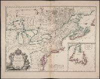
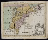
- Creator:
- Robert de Vaugondy, Didier, 1723-1786
- Published / Created:
- 1753
- Call Number:
- 755 1753M
- Container / Volume:
- BRBL_00426
- Image Count:
- 1
- Resource Type:
- Maps, Atlases & Globes
- Subject (Geographic):
- United States--Maps--Early works to
- Found in:
- Beinecke Rare Book and Manuscript Library > Carte des pays connus sous le nom de Canada : dans laquelle sont distinguées les possessions françoises, & angl? Dédiée et présentée a monseigneur le Comte d'Argenson, ministre sécrétaire d'Etat pour le département de la guerre / par le Sr. Rober
- Creator:
- Gibson, J. (John)
- Published / Created:
- 1763]
- Call Number:
- 71 1763G
- Container / Volume:
- BRBL_00726
- Image Count:
- 1
- Resource Type:
- Maps, Atlases & Globes
- Subject (Geographic):
- United States--Maps--Early works to
- Found in:
- Beinecke Rare Book and Manuscript Library > The British governments in Nth. America [cartographic material] : laid down agreeable to the proclamation of Octr. 7, 1763 / J. Gibson sculp.
- Creator:
- Faden, William, 1749-1836
- Published / Created:
- 1777
- Call Number:
- 73 1777
- Container / Volume:
- BRBL_00373
- Image Count:
- 1
- Resource Type:
- Maps, Atlases & Globes
- Subject (Geographic):
- Canada--Boundaries--United States--Maps
- Found in:
- Beinecke Rare Book and Manuscript Library > A map of the inhabited part of Canada from the French surveys, with the frontiers of New York and New England; from the large survey by Claude Joseph Sauthier. Engraved by Wm. Faden, 1777.
- Creator:
- Kitchin, Thomas, d. 1784
- Published / Created:
- June 1st. 1789.
- Call Number:
- 755 1789
- Container / Volume:
- BRBL_00435
- Image Count:
- 1
- Resource Type:
- Maps, Atlases & Globes
- Subject (Geographic):
- United States--Maps--Early works to
- Found in:
- Beinecke Rare Book and Manuscript Library > North America, wherein are particularly distinguished the British dominions, the United States, and the adjacent Spanish territories / by Thomas Kitchin, hydrographer to His Majesty.
- Published / Created:
- [1759-1771] and 1763 May
- Call Number:
- Z17 289q
- Image Count:
- 1
- Resource Type:
- Books, Journals & Pamphlets
- Subject (Geographic):
- United States--Maps--Early works to
- Found in:
- Beinecke Rare Book and Manuscript Library > Royal magazine; or, Gentleman's monthly companion.
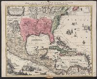
- Creator:
- Seutter, Matthaeus, 1678-1756, cartographer
- Published / Created:
- [1735?]
- Call Number:
- 85 1735
- Container / Volume:
- BRBL_00636
- Image Count:
- 1
- Resource Type:
- Maps, Atlases & Globes
- Subject (Geographic):
- United States--Maps--Early works to
- Found in:
- Beinecke Rare Book and Manuscript Library > Mappa geographica regionem Mexicanam et Floridam : terrasque adjacentes, ut et Anteriores Americae insulas cursus itedem et reditus navigantium versus flumen Missisipi et alias colonias ob oculas ponens / cura et sumptibus Matthaei Seutteri ; Tob. Con. Lo