Search
You Searched For
Search Results
- Creator:
- From the Collection: Hansen, Bert, 1944-
- Published / Created:
- 1910 June 29
- Call Number:
- Ms Coll 67
- Container / Volume:
- Box 11, folder 32
- Image Count:
- 1
- Found in:
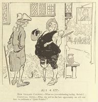
- Medical Historical Library, Cushing/Whitney Medical Library > The Bert Hansen collection of medicine and public health in popular graphic art (Ms Coll 67) > Series I: Early Publications > Puck > "July 4, 1775. New England Colonist 'What are you celebrating to-day, Beriah?' Convivial Ditto 'Why, this will be the last opportunity we will ever have to celebrate a "Quiet Fourth"'!"
- Call Number:
- 1978 +73
- Collection Title:
- The ecclesiastical history of New-England from its first planting in the year 1620 unto the year of
- Image Count:
- 2
- Resource Type:
- Books, Journals & Pamphlets
- Subject (Geographic):
- New England --Biography
- Found in:
- Beinecke Rare Book and Manuscript Library > ... Praying people have been the chariots and the horse-men thereof
- Published / Created:
- [1710]
- Call Number:
- 771cea 1710
- Container / Volume:
- BRBL_00493
- Image Count:
- 1
- Resource Type:
- Maps, Atlases & Globes
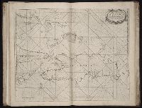
- Found in:
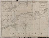
- Beinecke Rare Book and Manuscript Library > A Chart of the Sea Coasts of New Neder Land, Virginia, New England and Penn-Silvania with the city of Philadelphia from Boston to Cabo Karrit.
- Published / Created:
- 1732
- Call Number:
- NZ Z732c
- Image Count:
- 42
- Resource Type:
- Books, Journals & Pamphlets
- Subject (Geographic):
- New England--Commerce.
- Found in:
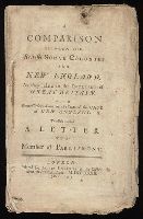
- Beinecke Rare Book and Manuscript Library > A Comparison between the British sugar colonies and New England, as they relate to the interest of Great Britain : with some observations on the state of the case of New England; to which is added A letter to a member of Parliament.
- Published / Created:
- 1776
- Call Number:
- Cb23 27
- Collection Title:
- The American military pocket atlas : being an approved collection of correct maps, both general and
- Image Count:
- 1
- Alternative Title:
- , Newfoundland, Nova-Scotia, New-England, New-York
- Subject (Geographic):
- New England --Maps --Early works to
- Found in:
- Beinecke Rare Book and Manuscript Library > A General map of the northern British colonies in America. which comprehends the province of Quebec, the government of Newfoundland, Nova-Scotia, New-England and New-York. From the maps published by the Admiralty and Board of Trade regulated by the astronomic and trigonometric observations of M. von Holland and corrected from Governor Pownall's late map 1776.
- Published / Created:
- [1775?]
- Call Number:
- 76cea 1775
- Container / Volume:
- BRBL_00446
- Image Count:
- 1
- Resource Type:
- Maps, Atlases & Globes
- Description:
- Insets: The Town of Boston in new
- Subject (Geographic):
- New England--Maps--Early works to 1800
- Found in:
- Beinecke Rare Book and Manuscript Library > A Map of the Coast of New England from Staten Island of Breton; as if was actualy survey'd by Capt. Cyprian Southback.
- Published / Created:
- [1775?]
- Call Number:
- 76cea 1775A
- Container / Volume:
- BRBL_00446
- Image Count:
- 1
- Resource Type:
- Maps, Atlases & Globes
- Description:
- Insets: The Town of Boston in New
- Subject (Geographic):
- New England--Maps--Early works to 1800
- Found in:
- Beinecke Rare Book and Manuscript Library > A Map of the Coast of New England from Staten Island to the Island of Breton; as it was actualy survey'd by Capt Cyprian Southback.
- Published / Created:
- [1774]
- Call Number:
- 76 1774
- Container / Volume:
- BRBL_00729
- Image Count:
- 1
- Resource Type:
- Maps, Atlases & Globes
- Abstract:
- Subject: Map of New England and Long
- Subject (Geographic):
- New England--Maps
- Found in:
- Beinecke Rare Book and Manuscript Library > A Map of the most inhabited part of New England [cartographic material] : containing the provinces of Massachusets Bay and New Hampshire with the colonies of Conecticut and Rhode Island divided into counties and townships : The whole composed from actual
- Published / Created:
- [1774]
- Call Number:
- 76 1774
- Container / Volume:
- BRBL_00729
- Image Count:
- 2
- Resource Type:
- Maps, Atlases & Globes
- Abstract:
- Subject: Map of New England and Long
- Subject (Geographic):
- New England--Maps
- Found in:
- Beinecke Rare Book and Manuscript Library > A Map of the most inhabited part of New England [cartographic material] : containing the provinces of Massachusets Bay and New Hampshire with the colonies of Conecticut and Rhode Island divided into counties and townships : The whole composed from actual
- Published / Created:
- [1774]
- Call Number:
- 76 1774
- Container / Volume:
- BRBL_00443
- Image Count:
- 2
- Resource Type:
- Maps, Atlases & Globes
- Abstract:
- Subject: Map of New England and Long
- Subject (Geographic):
- New England--Maps
- Found in:
- Beinecke Rare Book and Manuscript Library > A Map of the most inhabited part of New England [cartographic material] : containing the provinces of Massachusets Bay and New Hampshire with the colonies of Conecticut and Rhode Island divided into counties and townships : The whole composed from actual
- Published / Created:
- 1794
- Call Number:
- 755cea 1794
- Container / Volume:
- BRBL_00441
- Image Count:
- 4
- Resource Type:
- Maps, Atlases & Globes
- Found in:
- Beinecke Rare Book and Manuscript Library > A New and Correct Chart of the Coast of New England and New York with the adjacent parts of Nova Scotia and New Brunswick from Cape Sable to the entrance of Hudsons or North River by Captain Holland.
- Published / Created:
- [1764?]
- Call Number:
- 76cea 1764
- Container / Volume:
- BRBL_00446
- Image Count:
- 1
- Resource Type:
- Maps, Atlases & Globes
- Subject (Geographic):
- New England--Maps--Early works to 1800
- Found in:
- Beinecke Rare Book and Manuscript Library > A New and Correct Chart of the Sea Coast of New-England, from Cape Codd to Casco Bay. Lately Surbey'd by Capt. Henry Barnsley.
- Published / Created:
- 1711
- Call Number:
- 764 B65 1711
- Container / Volume:
- BRBL_00710
- Image Count:
- 1
- Resource Type:
- Maps, Atlases & Globes
- Found in:
- Beinecke Rare Book and Manuscript Library > A New plan of the Harbour of Boston in New England. Lat. 42, 29 North. Long. 71 West. Surveyed by Order of the Commissioners of her Majesty's Navy.
- Call Number:
- 1978 Folio 10
- Collection Title:
- ... : also a new description of Newfound-Land, New-England, New-York, east and west New-Jerzey, Dellewar-Bay
- Image Count:
- 2
- Found in:
- Beinecke Rare Book and Manuscript Library > A chart of the Caribe Islands
- Call Number:
- 1973 Folio 76
- Collection Title:
- of New-found-land, New-England, New-York, Dellewar-Bay, Virginia, Mary-land and Carrolina, &c
- Image Count:
- 1
- Found in:
- Beinecke Rare Book and Manuscript Library > A chart of the Caribe ilands
- Creator:
- Waddington, Robert
- Call Number:
- 1973 Folio 116
- Collection Title:
- ... : also a new description of Newfoundland, New-England, New-York, east and west New-Jersey, Dellawar-Bay
- Image Count:
- 1
- Found in:
- Beinecke Rare Book and Manuscript Library > A chart of the coast of Guayana, from the entrance of the River Orinoco ...
- Call Number:
- 1973 Folio 76
- Collection Title:
- of New-found-land, New-England, New-York, Dellewar-Bay, Virginia, Mary-land and Carrolina, &c
- Image Count:
- 1
- Found in:
- Beinecke Rare Book and Manuscript Library > A chart of the iland of Hispaniola
- Call Number:
- 1978 Folio 10
- Collection Title:
- ... : also a new description of Newfound-Land, New-England, New-York, east and west New-Jerzey, Dellewar-Bay
- Image Count:
- 1
- Found in:
- Beinecke Rare Book and Manuscript Library > A chart of the island of Hispaniola
- Call Number:
- 1978 Folio 10
- Collection Title:
- ... : also a new description of Newfound-Land, New-England, New-York, east and west New-Jerzey, Dellewar-Bay
- Image Count:
- 1
- Subject (Geographic):
- New England --Maps --Early works to
- Found in:
- Beinecke Rare Book and Manuscript Library > A chart of the sea coast of New Found Land, New Scotland, New England, New York, New Jersey, with Virginia and Maryland