Search
You Searched For
Search Results
- Creator:
- Erdoes, Richard, 1912-2008
- Call Number:
- WA MSS S-2609
- Collection Title:
- Richard Erdoes papers
- Container / Volume:
- Box 65 | San Ildefonso Dances, Pueblos
- Image Count:
- 19
- Subject (Geographic):
- North America--Maps
- Found in:
- Beinecke Rare Book and Manuscript Library > Maps
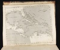
- Creator:
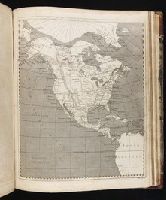
- Marshall, Thomas
- Call Number:
- 1974 +231
- Collection Title:
- A new and elegant general atlas, comprising all the new discoveries, to the present time
- Image Count:
- 1
- Subject (Geographic):
- North America--Maps
- Found in:
- Beinecke Rare Book and Manuscript Library > West Indies
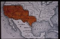
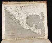
- Creator:
- Hooker, William
Jones, Benjamin
- Call Number:
- 1974 +231
- Collection Title:
- A new and elegant general atlas, comprising all the new discoveries, to the present time
- Image Count:
- 1
- Subject (Geographic):
- North America--Maps
- Found in:
- Beinecke Rare Book and Manuscript Library > Spanish dominions in North America
- Creator:
- Hooker, William
Jones, Benjamin
- Call Number:
- 1974 +231
- Collection Title:
- A new and elegant general atlas, comprising all the new discoveries, to the present time
- Image Count:
- 1
- Subject (Geographic):
- North America--Maps
- Found in:
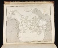
- Beinecke Rare Book and Manuscript Library > British possessions in America
- Creator:
- Lewis, Samuel, 1753 or 4-1822
- Call Number:
- 1974 +231
- Collection Title:
- A new and elegant general atlas, comprising all the new discoveries, to the present time
- Image Count:
- 1
- Subject (Geographic):
- North America--Maps
- Found in:
- Beinecke Rare Book and Manuscript Library > [Map of the Louisiana Territory]
- Call Number:
- 1974 +231
- Collection Title:
- A new and elegant general atlas, comprising all the new discoveries, to the present time
- Image Count:
- 1
- Subject (Geographic):
- North America--Maps
- Found in:
- Beinecke Rare Book and Manuscript Library > [Map of the United States of America]
- Call Number:
- 1974 +231
- Collection Title:
- A new and elegant general atlas, comprising all the new discoveries, to the present time
- Image Count:
- 1
- Subject (Geographic):
- North America--Maps
- Found in:
- Beinecke Rare Book and Manuscript Library > [Map of North America]
- Creator:
- Thornton, John, 1641-1708
- Call Number:
- 1973 Folio 76
- Collection Title:
- The English pilot: describing the sea-coasts, capes, head-lands, rivers, bays, roads, havens
- Image Count:
- 1
- Subject (Geographic):
- North America --Maps --Early works to
- Found in:
- Beinecke Rare Book and Manuscript Library > A chart of ye north part of America
- Call Number:
- 1973 Folio 114
- Collection Title:
- The English pilot: describing the West-India navigation, from Hudson's-Bay to the river Amazones
- Image Count:
- 2
- Resource Type:
- Maps, Atlases & Globes
- Subject (Geographic):
- North America --Maps --Early works to
- Found in:
- Beinecke Rare Book and Manuscript Library > A new generall chart for the West Indies
- Call Number:
- 1973 Folio 116
- Collection Title:
- The English pilot: describing the West-India navigation, from Hudson's-Bay to the river Amazones
- Image Count:
- 1
- Subject (Geographic):
- North America --Maps --Early works to
- Found in:
- Beinecke Rare Book and Manuscript Library > A new generall chart for the West Indies
- Call Number:
- 1978 Folio 10
- Collection Title:
- The English pilot: describing the West-India navigation, from Hudson's-Bay to the river Amazones
- Image Count:
- 1
- Subject (Geographic):
- North America --Maps --Early works to
- Found in:
- Beinecke Rare Book and Manuscript Library > A new generall chart for the West Indies
- Creator:
- Gibson, J. (John)
- Call Number:
- 1973 Folio 67
- Collection Title:
- The West-India pilot: containing piloting directions for Port Royal and Kingston harbours in
- Image Count:
- 1
- Subject (Topic):
- Harbors --Atlantic Coast (North America
- Found in:
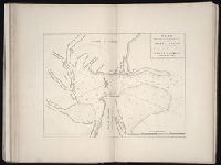
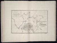
- Beinecke Rare Book and Manuscript Library > References for the plan of the city and suburbs of Carthagena
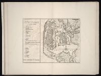
- Creator:
- Gibson, J. (John)
- Call Number:
- 1973 Folio 67
- Collection Title:
- The West-India pilot: containing piloting directions for Port Royal and Kingston harbours in
- Image Count:
- 1
- Subject (Topic):
- Harbors --Atlantic Coast (North America
- Found in:
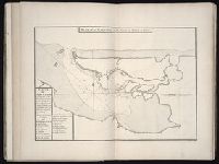
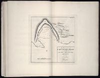
- Beinecke Rare Book and Manuscript Library > Plan of the town harbour of Puerto Vello
- Call Number:
- 1973 Folio 67
- Collection Title:
- The West-India pilot: containing piloting directions for Port Royal and Kingston harbours in
- Image Count:
- 1
- Subject (Topic):
- Harbors --Atlantic Coast (North America
- Found in:
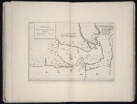
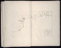
- Beinecke Rare Book and Manuscript Library > Plan of the entrance into Cape Fear harbour, North Carolina
- Call Number:
- 1973 Folio 67
- Collection Title:
- The West-India pilot: containing piloting directions for Port Royal and Kingston harbours in
- Image Count:
- 1
- Subject (Topic):
- Harbors --Atlantic Coast (North America
- Found in:
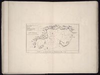
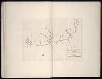
- Beinecke Rare Book and Manuscript Library > Plan du port de Gouadaquini now called Jekil Sound in the province of Georgia in North America
- Creator:
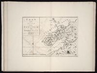
- Gibson, J. (John)
- Call Number:
- 1973 Folio 67
- Collection Title:
- The West-India pilot: containing piloting directions for Port Royal and Kingston harbours in
- Image Count:
- 1
- Subject (Topic):
- Harbors --Atlantic Coast (North America
- Found in:
- Beinecke Rare Book and Manuscript Library > Aiguiade de Port o Rico
- Creator:
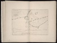
- Gibson, J. (John)
- Call Number:
- 1973 Folio 67
- Collection Title:
- The West-India pilot: containing piloting directions for Port Royal and Kingston harbours in
- Image Count:
- 1
- Subject (Topic):
- Harbors --Atlantic Coast (North America
- Found in:
- Beinecke Rare Book and Manuscript Library > Plan of the harbour of St. Juan de Port o Rico
- Call Number:
- 1973 Folio 67
- Collection Title:
- The West-India pilot: containing piloting directions for Port Royal and Kingston harbours in
- Image Count:
- 1
- Subject (Topic):
- Harbors --Atlantic Coast (North America
- Found in:
- Beinecke Rare Book and Manuscript Library > Plan du cul de sac de Leogane ou le Port au Prince
- Call Number:
- 1973 Folio 67
- Collection Title:
- The West-India pilot: containing piloting directions for Port Royal and Kingston harbours in
- Image Count:
- 1
- Subject (Topic):
- Harbors --Atlantic Coast (North America
- Found in:
- Beinecke Rare Book and Manuscript Library > Island of Old Providence
- Creator:
- Bowen, Thomas, d. 1790
- Call Number:
- 1973 Folio 67
- Collection Title:
- The West-India pilot: containing piloting directions for Port Royal and Kingston harbours in
- Image Count:
- 1
- Subject (Topic):
- Harbors --Atlantic Coast (North America
- Found in:
- Beinecke Rare Book and Manuscript Library > Plan of Blewfields Harbour on the Mosquito Shore
- Call Number:
- 1973 Folio 67
- Collection Title:
- The West-India pilot: containing piloting directions for Port Royal and Kingston harbours in
- Image Count:
- 1
- Subject (Topic):
- Harbors --Atlantic Coast (North America
- Found in:
- Beinecke Rare Book and Manuscript Library > Plan of Port Royal harbour Rattan
- Creator:
- Bayly, J
- Call Number:
- 1973 Folio 67
- Collection Title:
- The West-India pilot: containing piloting directions for Port Royal and Kingston harbours in
- Image Count:
- 1
- Subject (Topic):
- Harbors --Atlantic Coast (North America
- Found in:
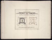
- Beinecke Rare Book and Manuscript Library > Plan of the fortification now finishing in the port of St. Fernando de Omoa
- Call Number:
- 1973 Folio 67
- Collection Title:
- The West-India pilot: containing piloting directions for Port Royal and Kingston harbours in
- Image Count:
- 1
- Subject (Topic):
- Harbors --Atlantic Coast (North America
- Found in:
- Beinecke Rare Book and Manuscript Library > Plan of port of St. Fernando de Omoa near Honduras
- Call Number:
- 1973 Folio 67
- Collection Title:
- The West-India pilot: containing piloting directions for Port Royal and Kingston harbours in
- Image Count:
- 1
- Subject (Topic):
- Harbors --Atlantic Coast (North America
- Found in:
- Beinecke Rare Book and Manuscript Library > Chart of the Bay of Honduras
- Creator:
- Gibson, J. (John)
- Call Number:
- 1973 Folio 67
- Collection Title:
- The West-India pilot: containing piloting directions for Port Royal and Kingston harbours in
- Image Count:
- 1
- Subject (Topic):
- Harbors --Atlantic Coast (North America
- Found in:
- Beinecke Rare Book and Manuscript Library > Plan of Vera Cruz
- Creator:
- Gibson, J. (John)
- Call Number:
- 1973 Folio 67
- Collection Title:
- The West-India pilot: containing piloting directions for Port Royal and Kingston harbours in
- Image Count:
- 1
- Subject (Topic):
- Harbors --Atlantic Coast (North America
- Found in:
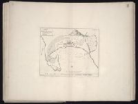
- Beinecke Rare Book and Manuscript Library > Plan of the Bay of Matanzas
- Creator:
- Bayly, J
- Call Number:
- 1973 Folio 67
- Collection Title:
- The West-India pilot: containing piloting directions for Port Royal and Kingston harbours in
- Image Count:
- 1
- Subject (Topic):
- Harbors --Atlantic Coast (North America
- Found in:
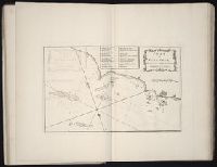
- Beinecke Rare Book and Manuscript Library > Plan of the harbour and city of Havanah
- Call Number:
- 1973 Folio 67
- Collection Title:
- The West-India pilot: containing piloting directions for Port Royal and Kingston harbours in
- Image Count:
- 1
- Subject (Topic):
- Harbors --Atlantic Coast (North America
- Found in:
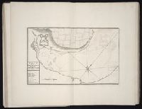
- Beinecke Rare Book and Manuscript Library > Plan du Cap Francois
- Call Number:
- 1973 Folio 67
- Collection Title:
- The West-India pilot: containing piloting directions for Port Royal and Kingston harbours in
- Image Count:
- 1
- Subject (Topic):
- Harbors --Atlantic Coast (North America
- Found in:
- Beinecke Rare Book and Manuscript Library > Plan de la Rade du Port Paix
- Call Number:
- 1973 Folio 67
- Collection Title:
- The West-India pilot: containing piloting directions for Port Royal and Kingston harbours in
- Image Count:
- 1
- Subject (Topic):
- Harbors --Atlantic Coast (North America
- Found in:
- Beinecke Rare Book and Manuscript Library > Plan of Cape Nichola Mole at the n.w. end of the island of Hispaniola
- Call Number:
- 1973 Folio 67
- Collection Title:
- The West-India pilot: containing piloting directions for Port Royal and Kingston harbours in
- Image Count:
- 1
- Subject (Topic):
- Harbors --Atlantic Coast (North America
- Found in:
- Beinecke Rare Book and Manuscript Library > Plan of Mantica Bay on the north side of Jamaica
- Call Number:
- 1973 Folio 67
- Collection Title:
- The West-India pilot: containing piloting directions for Port Royal and Kingston harbours in
- Image Count:
- 1
- Subject (Topic):
- Harbors --Atlantic Coast (North America
- Found in:
- Beinecke Rare Book and Manuscript Library > Plan of Lucia Harbour on the north side of Jamaica
- Call Number:
- 1973 Folio 67
- Collection Title:
- The West-India pilot: containing piloting directions for Port Royal and Kingston harbours in
- Image Count:
- 1
- Subject (Topic):
- Harbors --Atlantic Coast (North America
- Found in:
- Beinecke Rare Book and Manuscript Library > Plan of Blewfield's Harbour on the island of Jamaica
- Call Number:
- 1973 Folio 67
- Collection Title:
- The West-India pilot: containing piloting directions for Port Royal and Kingston harbours in
- Image Count:
- 1
- Subject (Topic):
- Harbors --Atlantic Coast (North America
- Found in:
- Beinecke Rare Book and Manuscript Library > Plan of Port Antonio on the north-east side of Jamaica
- Call Number:
- 1974 Folio 72
- Collection Title:
- The English pilot: describing the West-India navigation, from Hudson's-Bay to the river Amazones
- Image Count:
- 1
- Subject (Geographic):
- Atlantic Coast (North America) --Maps
- Found in:
- Beinecke Rare Book and Manuscript Library > A chart of the sea coast of Newfoundland, New Scotland, New England, New York, New Jersey, with Virginia and Maryland
- Call Number:
- 1974 Folio 72
- Collection Title:
- The English pilot: describing the West-India navigation, from Hudson's-Bay to the river Amazones
- Image Count:
- 2
- Subject (Geographic):
- Atlantic Coast (North America) --Maps
- Found in:
- Beinecke Rare Book and Manuscript Library > A generall chart of the western ocean
- Call Number:
- 1974 Folio 72
- Collection Title:
- The English pilot: describing the West-India navigation, from Hudson's-Bay to the river Amazones
- Image Count:
- 1
- Subject (Geographic):
- North America --Maps --Early works to
- Found in:
- Beinecke Rare Book and Manuscript Library > A new generall chart for the West Indies
- Call Number:
- 1973 Folio 116
- Collection Title:
- The English pilot: describing the West-India navigation, from Hudson's-Bay to the river Amazones
- Image Count:
- 2
- Subject (Geographic):
- North America --Maps --Early works to
- Found in:
- Beinecke Rare Book and Manuscript Library > A new and correct chart of the western and southern oceans
- Call Number:
- 1973 Folio 114
- Collection Title:
- The English pilot: describing the West-India navigation, from Hudson's-Bay to the river Amazones
- Image Count:
- 1
- Resource Type:
- Maps, Atlases & Globes
- Subject (Geographic):
- North America --Maps --Early works to
- Found in:
- Beinecke Rare Book and Manuscript Library > A new and correct chart of the western and southern oceans ...
- Creator:
- Thornton, John, 1641-1708
- Call Number:
- 1973 Folio 76
- Collection Title:
- The English pilot: describing the sea-coasts, capes, head-lands, rivers, bays, roads, havens
- Image Count:
- 1
- Subject (Geographic):
- North America --Maps --Early works to
- Found in:
- Beinecke Rare Book and Manuscript Library > A generall chart of the West Indies
- Call Number:
- 1973 Folio 67
- Collection Title:
- The West-India pilot: containing piloting directions for Port Royal and Kingston harbours in
- Image Count:
- 1
- Subject (Topic):
- Harbors --Atlantic Coast (North America
- Found in:
- Beinecke Rare Book and Manuscript Library > Plan of the harbour of Port Royal in the island of Jamaica
- Creator:
- Harris, I., d. 1739
- Call Number:
- 1978 Folio 10
- Collection Title:
- The English pilot: describing the West-India navigation, from Hudson's-Bay to the river Amazones
- Image Count:
- 1
- Subject (Geographic):
- North America --Maps --Early works to
- Found in:
- Beinecke Rare Book and Manuscript Library > A new and correct chart shewing the variations of the compass in the western & southern oceans
- Call Number:
- 1974 Folio 72
- Collection Title:
- The English pilot: describing the West-India navigation, from Hudson's-Bay to the river Amazones
- Image Count:
- 1
- Subject (Geographic):
- North America --Maps --Early works to
- Found in:
- Beinecke Rare Book and Manuscript Library > A new and correct chart of the western and southern oceans
- Call Number:
- 1976 1233
- Collection Title:
- Forty-two new maps of Asia, Africa, and America ... : all engrav’d, according to the latest
- Image Count:
- 1
- Subject (Geographic):
- North America --Maps --Early works to
- Found in:
- Beinecke Rare Book and Manuscript Library > A new map of North America according to the newest observations
- Call Number:
- 1976 1233
- Collection Title:
- Forty-two new maps of Asia, Africa, and America ... : all engrav’d, according to the latest
- Image Count:
- 1
- Subject (Geographic):
- North America --Maps --Early works to
- Found in:
- Beinecke Rare Book and Manuscript Library > A map of America according to ye newest and most exact observations
- Published / Created:
- Undated
- Call Number:
- Taylor 355
- Collection Title:
- America painted to the life. The true history of the Spaniards proceedings in the conquests of the
- Image Count:
- 1
- Subject (Geographic):
- North America --Maps --Early works to
- Found in:
- Beinecke Rare Book and Manuscript Library > Americae descrip
- Creator:
- National Railway Publication Company
- Call Number:
- BrSides Zc19 N82h 870na
- Image Count:
- 1
- Resource Type:
- Maps, Atlases & Globes
- Subject (Geographic):
- North America--Maps.
- Found in:
- Beinecke Rare Book and Manuscript Library > Map of the Northern Pacific Railway and tributary country.
- Call Number:
- BrSides Double Folio 2017 38
- Image Count:
- 1
- Resource Type:
- Maps, Atlases & Globes
- Subject (Geographic):
- North America--Maps--Early works to
- Found in:
- Beinecke Rare Book and Manuscript Library > The theatre of war in North America, with the roads, and tables, of the superficial contents, distances, & ca. / by an American.
- Call Number:
- 735 1790
- Container / Volume:
- BRBL_00689
- Image Count:
- 1
- Resource Type:
- Maps, Atlases & Globes
- Subject (Geographic):
- North America--Maps--Early works to
- Found in:
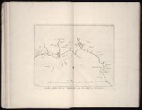
- Beinecke Rare Book and Manuscript Library > A map shewing the communication of the lakes and the rivers between Lake Superior and Slave Lake in North America.
- Creator:
- Dunn, Samuel, d. 1794
- Call Number:
- 71 1776
- Container / Volume:
- BRBL_00687
- Image Count:
- 1
- Resource Type:
- Maps, Atlases & Globes
- Subject (Geographic):
- North America--Maps--Early works to
- Found in:
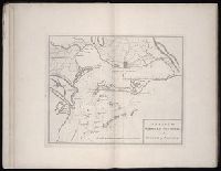
- Beinecke Rare Book and Manuscript Library > A map of the British Empire, in North America / by Samuel Dunn, mathematician, improved from the surveys of Capt. Carver.