James D. Hutton collection of drawings and photographs.
Container / Volume:
Box 1 | Folder 4
Image Count:
2
Abstract:
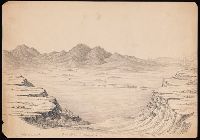
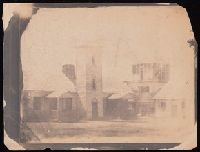
Four salted paper prints made during the Raynolds expedition of 1859-1860 depicting Laramie Hills with tipis in the foreground; a fort, possibly Fort Union; two sets of group portraits of Arapahos, one of them of Arapaho chiefs Eagle Head, Split-nose, Little Owl, and Friday. There are 17 drawings by Hutton, 11 of them of western views, most probably made during the Raynolds expedition, depicting Fort Sarpy on the Yellowstone; Eagle Creek on the upper Missouri River; the valley of Wind River; Red Canon Creek, Big Horn Mountains; and Lodge Pole Peak and Crow Peak in the Black Hills. There are nine other drawings present, six by three other identified artists: R. W. Ingle, W. Taylor, Jr., and William Rich Hutton, James' brother. The drawing by William Rich Hutton is a view of San Francisco. Accompanied by a document made out to Miss Ellen S. Hutton in thanks for her work as church organist.
Description:
Accompanied by a container list., James D. Hutton headed the photographic unit of the 1856-1860 expedition led by Captain William Franklin Raynolds to the Yellowstone and the Wind River Mountains., and See also Hutton photographs in the William Franklin Raynolds Papers, WA MSS 393.
Subject (Geographic):
SanFrancisco (Calif.)--Pictorial works
Subject (Name):
Hutton, Wm. R.--(William Rich),--1826-1901, Ingle, R. W.,--artist, and Raynolds, W. F.--(William Franklin),--1820-1894
Subject (Topic):
Arapaho Indians--Portraits and Indians of North America--Portraits
James D. Hutton collection of drawings and photographs.
Container / Volume:
Box 1 | Folder 7
Image Count:
1
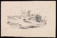
Abstract:
Four salted paper prints made during the Raynolds expedition of 1859-1860 depicting Laramie Hills with tipis in the foreground; a fort, possibly Fort Union; two sets of group portraits of Arapahos, one of them of Arapaho chiefs Eagle Head, Split-nose, Little Owl, and Friday. There are 17 drawings by Hutton, 11 of them of western views, most probably made during the Raynolds expedition, depicting Fort Sarpy on the Yellowstone; Eagle Creek on the upper Missouri River; the valley of Wind River; Red Canon Creek, Big Horn Mountains; and Lodge Pole Peak and Crow Peak in the Black Hills. There are nine other drawings present, six by three other identified artists: R. W. Ingle, W. Taylor, Jr., and William Rich Hutton, James' brother. The drawing by William Rich Hutton is a view of San Francisco. Accompanied by a document made out to Miss Ellen S. Hutton in thanks for her work as church organist.
Alternative Title:
Lodge pole Peak, Crow Peak - in Black Hills
Description:
Accompanied by a container list., James D. Hutton headed the photographic unit of the 1856-1860 expedition led by Captain William Franklin Raynolds to the Yellowstone and the Wind River Mountains., See also Hutton photographs in the William Franklin Raynolds Papers, WA MSS 393., and Verso is blank.
Subject (Geographic):
SanFrancisco (Calif.)--Pictorial works
Subject (Name):
Hutton, Wm. R.--(William Rich),--1826-1901, Ingle, R. W.,--artist, and Raynolds, W. F.--(William Franklin),--1820-1894
Subject (Topic):
Arapaho Indians--Portraits and Indians of North America--Portraits
James D. Hutton collection of drawings and photographs.
Container / Volume:
Box 1 | Folder 9
Image Count:
1
Abstract:
Four salted paper prints made during the Raynolds expedition of 1859-1860 depicting Laramie Hills with tipis in the foreground; a fort, possibly Fort Union; two sets of group portraits of Arapahos, one of them of Arapaho chiefs Eagle Head, Split-nose, Little Owl, and Friday. There are 17 drawings by Hutton, 11 of them of western views, most probably made during the Raynolds expedition, depicting Fort Sarpy on the Yellowstone; Eagle Creek on the upper Missouri River; the valley of Wind River; Red Canon Creek, Big Horn Mountains; and Lodge Pole Peak and Crow Peak in the Black Hills. There are nine other drawings present, six by three other identified artists: R. W. Ingle, W. Taylor, Jr., and William Rich Hutton, James' brother. The drawing by William Rich Hutton is a view of San Francisco. Accompanied by a document made out to Miss Ellen S. Hutton in thanks for her work as church organist.
Alternative Title:
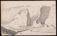
Lower Cañon of Red Cañon Creek Big Horn Mountains.
Description:
Accompanied by a container list., James D. Hutton headed the photographic unit of the 1856-1860 expedition led by Captain William Franklin Raynolds to the Yellowstone and the Wind River Mountains., See also Hutton photographs in the William Franklin Raynolds Papers, WA MSS 393., and Verso is blank.
Subject (Geographic):
SanFrancisco (Calif.)--Pictorial works
Subject (Name):
Hutton, Wm. R.--(William Rich),--1826-1901, Ingle, R. W.,--artist, and Raynolds, W. F.--(William Franklin),--1820-1894
Subject (Topic):
Arapaho Indians--Portraits and Indians of North America--Portraits
James D. Hutton collection of drawings and photographs.
Container / Volume:
Box 1 | Folder 3
Image Count:
1
Abstract:
Four salted paper prints made during the Raynolds expedition of 1859-1860 depicting Laramie Hills with tipis in the foreground; a fort, possibly Fort Union; two sets of group portraits of Arapahos, one of them of Arapaho chiefs Eagle Head, Split-nose, Little Owl, and Friday. There are 17 drawings by Hutton, 11 of them of western views, most probably made during the Raynolds expedition, depicting Fort Sarpy on the Yellowstone; Eagle Creek on the upper Missouri River; the valley of Wind River; Red Canon Creek, Big Horn Mountains; and Lodge Pole Peak and Crow Peak in the Black Hills. There are nine other drawings present, six by three other identified artists: R. W. Ingle, W. Taylor, Jr., and William Rich Hutton, James' brother. The drawing by William Rich Hutton is a view of San Francisco. Accompanied by a document made out to Miss Ellen S. Hutton in thanks for her work as church organist.
Description:
Accompanied by a container list., James D. Hutton headed the photographic unit of the 1856-1860 expedition led by Captain William Franklin Raynolds to the Yellowstone and the Wind River Mountains., See also Hutton photographs in the William Franklin Raynolds Papers, WA MSS 393., and Verso is blank.
Subject (Geographic):
SanFrancisco (Calif.)--Pictorial works
Subject (Name):
Hutton, Wm. R.--(William Rich),--1826-1901, Ingle, R. W.,--artist, and Raynolds, W. F.--(William Franklin),--1820-1894
Subject (Topic):
Arapaho Indians--Portraits and Indians of North America--Portraits
James D. Hutton collection of drawings and photographs.
Container / Volume:
Box 1 | Folder 8
Image Count:
1
Abstract:
Four salted paper prints made during the Raynolds expedition of 1859-1860 depicting Laramie Hills with tipis in the foreground; a fort, possibly Fort Union; two sets of group portraits of Arapahos, one of them of Arapaho chiefs Eagle Head, Split-nose, Little Owl, and Friday. There are 17 drawings by Hutton, 11 of them of western views, most probably made during the Raynolds expedition, depicting Fort Sarpy on the Yellowstone; Eagle Creek on the upper Missouri River; the valley of Wind River; Red Canon Creek, Big Horn Mountains; and Lodge Pole Peak and Crow Peak in the Black Hills. There are nine other drawings present, six by three other identified artists: R. W. Ingle, W. Taylor, Jr., and William Rich Hutton, James' brother. The drawing by William Rich Hutton is a view of San Francisco. Accompanied by a document made out to Miss Ellen S. Hutton in thanks for her work as church organist.
Description:
Accompanied by a container list., James D. Hutton headed the photographic unit of the 1856-1860 expedition led by Captain William Franklin Raynolds to the Yellowstone and the Wind River Mountains., See also Hutton photographs in the William Franklin Raynolds Papers, WA MSS 393., and Verso is blank.
Subject (Geographic):
SanFrancisco (Calif.)--Pictorial works
Subject (Name):
Hutton, Wm. R.--(William Rich),--1826-1901, Ingle, R. W.,--artist, and Raynolds, W. F.--(William Franklin),--1820-1894
Subject (Topic):
Arapaho Indians--Portraits and Indians of North America--Portraits
Bai la Trinidad., Bai und Hafen von MonteRey., Bai und Hafen von San Diego., Bai und Hafen von San Francisco., Bai und Hafen von Santa Barbara., Hafen San Pedro., Hafen von la Paz und Bai von Pichilingue., Hafen von San Francisco., and Mündungen der Flüsse Colorado
Description:
"Alfr. Hartmann, architect, entworf.", "Zu Hartmanns zweiten Bericht über Californien.", and Der Hafen San Pedro. Scale [ca. 1:140,000] -- Das Stromgebiet des San Sacramento nebst den Goldlagerstätten. Scale [ca. 1:3,800,000] -- Der Hafen von San Francisco. Scale [ca. 1:168,960] -- Die Bai la Trinidad. Scale [ca. 1:535,000] -- Der Hafen von la Paz und Bai von Pichilingue. Scale [ca. 1:220,000] -- Bai und Hafen von San Francisco. Scale [ca. 1:680,000] -- Bai und Hafen von MonteRey. Scale [ca. 1:300,000] -- Bai und Hafen von Santa Barbara. Scale [ca. 1:515,000] -- Bai und Hafen von San Diego. Scale [ca. 1:330,000] -- Mündungen der Flüsse Colorado und Gila. Scale [ca. 1:510,000].
Publisher:
Verlag und lithographie von B.F. Voigt,
Subject (Geographic):
SanFrancisco Bay (Calif.)--Maps
Subject (Name):
Voigt, Bernard Friedrich, 1787-1859
Subject (Topic):
Harbors--California--Maps, Harbors--Mexico--La Paz (Baja California Sur)--Maps, Naut, Nautical charts--California, Nautical charts--California--Monterey Bay, and Nautical charts--California--San Diego Bay
"Constructed, projected and drawn by Fred D. Stuart, hydrographer, late of the U.S. Ex. Ex.", "Entered according to act of Congress in the 1851 by Cadwalader Ringgold ....", "Sheet no. 1.", Inset view: Entrance to San Francisco., and Place names in English and Spanish.
Publisher:
C.B. Graham, Lithr.,
Subject (Geographic):
SanFrancisco Bay (Calif.)--Maps
Subject (Name):
Blunt, Simon Fraser, d. 1854, Graham, C. B. (Curtis B.), and Stuart, Fred D
"Entered according to act of Congress in the year 1851 by Cadwalader Ringgold ....", "Projected, constructed & drawn by Fred D. Stuart, hydrographer, late of the U.S. Ex. Ex. ; assisted by A.H. Campbell, civil engineer.", "Sheet no. 2.", and Inset views: Mark for invincible buoy, north extreme of Marin Is. on with clump of trees north of San Rafael -- Mark for invincible buoy, Point Smith, east end of Angel I. on with Signal Hill.
Publisher:
C.B. Graham, Lithr.,
Subject (Geographic):
SanFrancisco Bay (Calif.)--Maps
Subject (Name):
Blunt, Simon F, Campbell, Albert H. (Albert Henry), 1826-1899, Graham, C. B. (Curtis B.), and Stuart, Fred D
Subject (Topic):
Nautical charts--California--San Francisco Bay and Nautical charts--California--San Pablo Bay