4th impression of 3d French ed. Cf. Ristow, W.W. A la carte, p. 112., Includes text and inset "Nouvelle carte de la baye d'Hudson et de Labrador selon les dernieres cartes levées sur les lieux.", Prime meridian: London., Relief shown pictorially., and Title in F
Publisher:
Le Rouge?,
Subject (Geographic):
North America--Maps--Earlyworksto
Subject (Name):
Hawkins, M., fl. 1776-1792 and Le Rouge, Georges-Louis
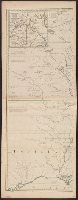
Particular map of Baffin and Hudson's Bay and Passage by land to California discover'd by Father Eusebius Francis Kino ...
Description:
"Longit. w. from Ferro.", Hand colored., Includes historical notes, notes on territorial claims, and insets of "A particular map of Baffin and Hudson's Bay" and "The passage by land to California.", and Relief shown pictorially.
Publisher:
Printed for Robert Sayer, no 53 Fleet Street ...,
Subject (Geographic):
North America--Maps--Earlyworksto
Subject (Name):
Gibson, J. (John), active 1750-1792 and Sayer, Robert, 1725-1794
An issue of the Pownall map of North America and the West Indies; appears similar to the 1783 and 1794 editions., Insets: A particular map of Baffin and Hudson's Bay -- The passage by land to California., Prime meridians: London and Ferro., and Relief shown pict
Hand colored., Relief shown pictorially., Shows "West longitude from London" and "from Philadelphia.", and Single sheet, uncolored, mounted on linen. Dimensions: 48 x 65 cm. Recto: Stamped "Yale Horace Brown 1900S".
Publisher:
Sold by T. Jefferys,
Subject (Geographic):
North America--Maps--Earlyworksto
Subject (Name):
Evans, Lewis, 1700?-1756, Jefferys, Thomas, d. 1771, and Mellon, Paul--Bookplate
Evans, Lewis, 1700?-1756 Gibson, J. (John), creator Jefferys, Thomas, d. 1771
Published / Created:
1758
Call Number:
2003 Folio 85
Image Count:
1
Alternative Title:
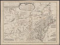
Middle British colonies
Description:
Available also through the Library of Congress Web site as a raster image., BEIN 2003 Folio 85: No. 17 of 45 maps bound together with binder's spine title: Atlas of America; ms. table of contents. Bookplate: Robinson. Bookplate of Paul Mellon., carefully copied from the original published at Philadelphia, by Mr. Lewis Evans 1755, with some improvements by I. Gibson., Hand colored., LC Maps of North America, 1750-1789,, Relief shown pictorially., Scale [ca. 1:2,250,000]., and Shows West longitude from London and from Philadelphia.
Accompanied by the author's: A topographical description of such parts of North America as are contained in the (annexed) map of the middle British colonies, &c. in North America. vi, 46, 16 p., Includes text, list of townships, distance charts, and inset "A sketch of the remaining part of Ohio R. &c.", Prime meridian: London and Philadelphia., Relief shown pictorially., and Without accompanying text.
Publisher:
Printed & published ... for J. Almon,
Subject (Geographic):
North America--Maps--Earlyworksto
Subject (Name):
Almon, John, 1737-1805, Evans, Lewis, 1700?-1756, and Turner, James, -1759
2nd state. Distinguishing feature of 2nd state: "Title changed slightly to read 'An accurate map of the British Colonies...'" (McCorkle 111)., 755 1756F: Verso: Stamped "Oct 23 1959"., Printed text in left and right margins., and Published separately as broadsid
Differs from other copies in absence of Connecticut River north of "Great Falls." Also differs in coloration of boundaries: Ohio and Kentucky Rivers are colored as boundaries; Pennsylvania extends north to a line at approximately 42⁰ 40ʹ; Maryland extends
"The seat of the war in the middle British colonies, containing Virginia, Maryland, the Delaware counties, &ca.", From the author's The American military pocket atlas. [1776], Hand colored., Inset: A sketch of the upper parts of Canada., and Relief shown pictoria
Publisher:
Printed for R. Sayer & J. Bennett, map, chart & printsellers,