Search
You Searched For
Search Results
- Creator:
- From the Collection: Brady, Mathew B., approximately 1823-1896
- Published / Created:
- circa 1860-1885
- Call Number:
- GEN MSS 580
- Container / Volume:
- Box 10, folder 524-525
- Image Count:
- 2
- Found in:
- Beinecke Rare Book and Manuscript Library > Mathew B. Brady and Levin Corbin Handy Photographic Studios Collection (GEN MSS 580) > Series I: Mathew B. Brady Studio > Oversize, Multiple Photographic Prints Mounted on Blue Board > Virginia, Arlington. 4th Michigan Infantry in camp
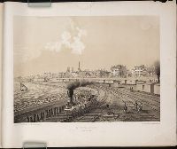
- Creator:
- Kurz, Louis, 1833-1921
- Published / Created:
- 1866-1867
- Call Number:
- 2003 Folio 18
- Collection Title:
- Chicago Illustrated
- Container / Volume:
- Pt. 10
- Image Count:
- 1
- Subject (Name):
- Michigan Avenue (Chicago, Ill.)
- Found in:
- Beinecke Rare Book and Manuscript Library > Michigan Avenue From the Lake
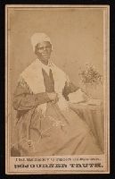
- Creator:
- From the Collection: Simpson, Randolph Linsly, 1927-1992
- Published / Created:
- 1864
- Call Number:
- JWJ MSS 54
- Container / Volume:
- Box 11, folder 515
- Image Count:
- 2
- Description:
- Michigan, stamped verso.
- Found in:
- Beinecke Rare Book and Manuscript Library > Randolph Linsly Simpson African-American Collection (JWJ MSS 54) > Series I. Visual Material > CARTES DE VISITE > Unknown Photographer Three quarter length portrait of Sojourner Truth; elderly woman wearing dress with shawl, bonnet, and glasses, seated beside small table with knitting, book, vase of flowers. Stamped recto beneath photograph, "I Sell the Shadow to Support the Substance. SOJOURNER TRUTH." Carte de visite
- Published / Created:
- 1853
- Call Number:
- 811 1853
- Container / Volume:
- BRBL_00552
- Image Count:
- 1
- Resource Type:
- Maps, Atlases & Globes
- Description:
- Inset map "Westl. Theil von Michigan."
- Subject (Geographic):
- Michigan--Maps
- Found in:
- Beinecke Rare Book and Manuscript Library > Neueste Karte von Michigan : nach den bessten Quellen bearbeitet.
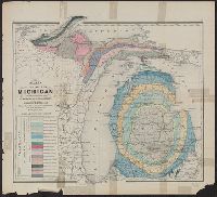
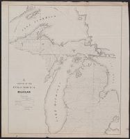
- Creator:
- Winchell, Alexander, 1824-1891
- Published / Created:
- 1873]
- Call Number:
- 811ca 1873
- Container / Volume:
- BRBL_00554
- Image Count:
- 1
- Resource Type:
- Maps, Atlases & Globes
- Description:
- From: Atlas of the state of Michigan
- Subject (Geographic):
- Michigan--Maps
- Subject (Name):
- . Atlas of the state of Michigan
- Subject (Topic):
- Geology--Michigan--Maps
- Found in:
- Beinecke Rare Book and Manuscript Library > Map of the state of Michigan colored to show the geological formations / by Alexander Winchell.
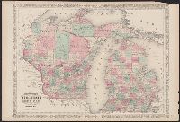
- Creator:
- Johnson, A. J. (Alvin Jewett), 1827-1884
- Published / Created:
- [1866]
- Call Number:
- 812 1866
- Container / Volume:
- BRBL_00555
- Image Count:
- 2
- Resource Type:
- Maps, Atlases & Globes
- Alternative Title:
- Wisconsin and Michigan
- Subject (Geographic):
- Michigan--Maps
- Subject (Topic):
- Counties--Michigan--Maps
- Found in:
- Beinecke Rare Book and Manuscript Library > Johnson's Wisconsin and Michigan.
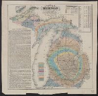
- Creator:
- Winchell, Alexander, 1824-1891
- Published / Created:
- 1866
- Call Number:
- 811ca 1866
- Container / Volume:
- BRBL_00554
- Image Count:
- 1
- Resource Type:
- Maps, Atlases & Globes
- Description:
- Michigan," population table, and inset of Isle
- Subject (Geographic):
- Michigan--Maps
- Subject (Topic):
- Geology--Michigan--Maps
- Found in:
- Beinecke Rare Book and Manuscript Library > Geological map of Michigan / by Alexander Winchell.
- Creator:
- Middleton, Strobridge & Co
- Published / Created:
- [1857].
- Call Number:
- 753gme 1858
- Container / Volume:
- BRBL_00415
- Image Count:
- 1
- Resource Type:
- Maps, Atlases & Globes
- Description:
- Mackinaw connecting Lake Michigan and Lake
- Subject (Topic):
- Counties--Michigan--Maps
- Found in:
- Beinecke Rare Book and Manuscript Library > Map illustrating the Canada Pacific and Northern Pacific and other proposed Railroads, connecting at Straits of Mackinaw : Also showing the position of Mackinaw City.
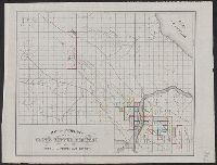
- Creator:
- Noble, Charles
- Published / Created:
- 1850
- Call Number:
- 811fcm 1850
- Container / Volume:
- BRBL_00554
- Image Count:
- 1
- Resource Type:
- Maps, Atlases & Globes
- Subject (Geographic):
- Michigan--Maps
- Found in:
- Beinecke Rare Book and Manuscript Library > Sketch of the public surveys in Michigan / Surveyor General's Office, Detroit, November 12th, 1850, Charles Noble, Surveyor General.
- Creator:
- J.O. Seymour & Co
- Published / Created:
- [ca. 1870]
- Call Number:
- 811gfc P831 1870
- Container / Volume:
- BRBL_00554
- Image Count:
- 1
- Resource Type:
- Maps, Atlases & Globes
- Subject (Topic):
- Copper mines and mining--Michigan
- Found in:
- Beinecke Rare Book and Manuscript Library > Map of property of the Globe Copper Company and mines in the Portage Lake District.