Skip to search
Skip to main content
Skip to first result
Search
You Searched For
Extent of Digitization
Completely digitized
Language
Dutch
Search Results
Creator:
Published / Created:
[1734]
Call Number:
1973 Folio 18
Image Count:
1
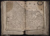
Description:
BEIN 1973 Folio 18: Backed with paper. Ms. no. "13" in upper right-hand corner. Sheet measures 53.6 x 62.8 cm. No. 12 of 87 maps bound together.
Publisher:
By Gerard van Keulen ...
Subject (Geographic):
Rügen Island (Germany), Stralsund (Germany), and Baltic Sea
Subject (Topic):
Maps and Nautical charts
Found in:
Beinecke Rare Book and Manuscript Library > Nieuwe afteekening van het eyland Rugen en de Straalsond als mede de stad Straalsond en t Nieuwe diep met alle desselfs gelegentheden int groot. [cartographic material]
Creator:
Published / Created:
[1728?]
Call Number:
1977 Folio 177
Image Count:
3
Alternative Title:
West Indien
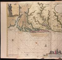
Description:
BEIN 1977 Folio 177: Imperfect: mutilated along fold, with some loss of text; several holes, with some loss of text. Backed with blue paper. Sheet measures 61.7 x 103.0 cm, folded to 53 x 34 cm. No. 34 of 34 maps bound together.
Publisher:
By Ioannes van Keulen ...
Subject (Geographic):
Caribbean Sea and West Indies
Subject (Topic):
Nautical charts
Found in:
Beinecke Rare Book and Manuscript Library > Nieuwe en Zeer Naaukeurige Paskaart van de Kusten van West Indien strekkende van Rio Oronoque tot Beneede Cartagena met alle de Caribische Eylanden als ook Porto Rico en de Zuyd Kust van Espaniola / [cartographic material]
Creator:
Published / Created:
[ca. 1720?]
Call Number:
1973 Folio 18
Image Count:
1
Description:
BEIN 1973 Folio 18: Backed with paper. Ms. no. "66" in upper right-hand corner. Sheet measures 53.7 x 62.3 cm. No. 61 of 87 maps bound together.
Publisher:
By Gerard van Keulen, aen de nieuwe Brug met privilegie
Subject (Geographic):
Sardinia (Italy) and Mediterranean Sea
Subject (Topic):
Maps and Nautical charts
Found in:
Beinecke Rare Book and Manuscript Library > Nieuwe en nette afteekening van het eyland of Koninkryk Sardinia vertoonende alle desselfs zee havenen anker plaetsen rivieren dieptens klippen steeden en vastigheeen als mede de Straet van Bonifacio aent eyland Corsica [cartographic material]
Creator:
Published / Created:
[ca. 1734]
Call Number:
1973 Folio 18
Image Count:
1
Description:
BEIN 1973 Folio 18: Backed with paper. Ms. no. "43" in upper right-hand corner. Sheet measures 53.7 x 62.9 cm. No. 41 of 87 maps bound together.
Publisher:
By Ioannes van Keulen ...
Subject (Geographic):
West Frisian Islands (Netherlands), Netherlands, and West Frisian Islands
Subject (Topic):
Maps and Nautical charts
Found in:
Beinecke Rare Book and Manuscript Library > Nieuwe pascaert waar in te sien is de gaten van Texel en 't Vlie met alle syn mercken, diepte en droogte / [cartographic material]
Creator:
Published / Created:
[ca. 1734]
Call Number:
1973 Folio 18
Image Count:
1
Alternative Title:
Noord-Bodem
Description:
BEIN 1973 Folio 18: Backed with paper. Ms. no. "14" in upper right-hand corner. Sheet measures 53.6 x 62.5 cm. No. 14 of 87 maps bound together.
Publisher:
By Johannes van Keulen ...
Subject (Geographic):
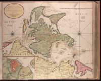
Finland, Sweden, and Bothnia, Gulf of
Subject (Topic):
Maps and Nautical charts
Found in:
Beinecke Rare Book and Manuscript Library > Nieuwe paskaart van de Noord-Bodem beginnende aen de Oost Zÿde van Abo tot Torne en aen de West-kant van Torne tot Gafle / [cartographic material]
Creator:
Published / Created:
[ca. 1734]
Call Number:
1973 Folio 18
Image Count:
1
Alternative Title:
Noorwegen
Description:
BEIN 1973 Folio 18: Backed with paper. Ms. no. "6" in upper right-hand corner. Sheet measures 53.4 x 62.0 cm. No. 5 of 87 maps bound together.
Publisher:
By Iohannis van Keulen ...
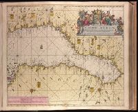
Subject (Geographic):
Hordaland fylke (Norway) and Norway
Subject (Topic):
Maps and Coasts
Found in:
Beinecke Rare Book and Manuscript Library > Nieuwe paskaart van de kust van Noorwegen beginnende van Bommelsondt tot aan de Wtweer Klippen Naauwkeurig opgestelt en van veel fouten verbeetert met Privilegie voor 15 Iaaren. [cartographic material]
Creator:
Published / Created:
1652.
Call Number:
1983 Folio 19
Image Count:
1
Alternative Title:
Nova 17 provinciarum discriptio and Nova XVII provinciarvm discriptio
Description:
BEIN 1983 Folio 19: Imperfect: torn and repaired along folds and in corners, with some loss of text. Sheet measures 38.8 x 54.8 cm. Reinforced along edges with manuscript waste. No. 50 of 92 maps bound together.
Publisher:
Apud Frederico de Widt
Subject (Geographic):
Netherlands
Found in:
Beinecke Rare Book and Manuscript Library > Nova XVII provinciarum discriptio
Creator:
From the Collection: Jong, Jacqueline de, 1939-
Published / Created:
[1962]
Call Number:
GEN MSS 832
Container / Volume:
Box 13, folder 327
Image Count:
1
Found in:
Beinecke Rare Book and Manuscript Library > Jacqueline de Jong papers (GEN MSS 832) > Series II: The Situationist Times Records > Issue no. 2 > Outline and notes for issue
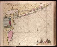
Creator:
Published / Created:
[ca. 1702?]
Call Number:
1973 Folio 18
Image Count:
2
Description:
BEIN 1973 Folio 18: Imperfect: stains at bottom, with no loss of text. Backed with paper. Ms. no. "94" in upper right-hand corner. Joined sheets measure 53.5 x 65.0 sm. or smaller. No. 84 of 87 maps bound together.
Publisher:
By Gerard van Keulen
Subject (Geographic):
Suriname
Subject (Topic):
Nautical charts, Maps, Rivers, and Coasts
Found in:
Beinecke Rare Book and Manuscript Library > Pas-kaart vande rivieren Commewini, Suriname, Suramaca, Cupanama en Courantin vertoonende alle desselfs plantagie en wie deselve bezitten, alles opt naukeurigste opgestelt. [cartographic material]
Creator:
Published / Created:
[ca. 1734]
Call Number:
1973 Folio 18
Image Count:
1
Alternative Title:
Noorwegen
Description:
BEIN 1973 Folio 18: Backed with paper. Ms. no. "7" in upper right-hand corner. Sheet measures 53.6 x 62.6 cm. No. 6 of 87 maps bound together.
Publisher:
By Iohannis van Keulen ...
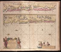
Subject (Geographic):
Sør-Trøndelag (Norway), Norway, and Trondheim Fjord
Subject (Topic):
Coasts and Nautical charts
Found in:
Beinecke Rare Book and Manuscript Library > Paskaart van de kust van Noorwegen : beginnende van Swarten Os tot aan Heyligelander Leen, Naaukeurigh opgestelt waar in vervaat werd 't Liet van Dronten : met Privilegie voor 15 Iaaren
Branch:v1.70.9 ,Deployed:2025-11-26T07:10:00-05:00