Skip to search
Skip to main content
Skip to first result
Search
You Searched For
Extent of Digitization
Completely digitized
Subject (Topic)
World maps--Early works to 1800
Search Results
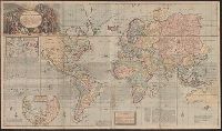
Published / Created:
1794
Call Number:
11 1794
Container / Volume:
BRBL_00724
Image Count:
2
Resource Type:
Maps, Atlases & Globes
Description:
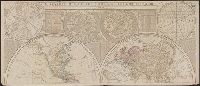
From: Thomas Kitchin, A general atlas ... , London, 1795, no. 1-2.
Publisher:
Laurie & Whittle,
Subject (Topic):
World maps--Early works to 1800
Found in:
Beinecke Rare Book and Manuscript Library > A general map of the world, or terraqueous globe ... / by Saml. Dunn, mathematician.
Creator:
Published / Created:
1651 [1676 printing]
Call Number:
11 1651
Container / Volume:
BRBL_00680
Image Count:
1
Resource Type:
Maps, Atlases & Globes
Alternative Title:
New and accurate map of the world and New and accvrat map of the world
Description:
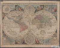
Appeared in Speed's A prospect of the most famous parts of the world... London...1676.
Publisher:
Are to be sold by Tho. Bassett ... and Ric. Chiswell ...,
Subject (Name):
Bassett, Thomas, bookseller, bookseller, Chiswell, Richard, bookseller, and Speed, John, 1552?-1629. Prospect of the most famous parts of the world
Subject (Topic):
World maps--Early works to 1800
Found in:
Beinecke Rare Book and Manuscript Library > A new and accurat map of the world : drawne according to ye truest descriptions, latest discoueries & best obseruations y[e]t have beene made by english or strangers.
Creator:
Call Number:
Lanman 11 1659A
Image Count:
1
Resource Type:
Maps, Atlases & Globes
Alternative Title:
New and accurat map of the world and New and accurate map of the world
Description:
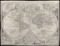
Attributed to Robert Walton; based on a map by John Speed.
Subject (Name):
Petau, Denis, 1583-1652 and Speed, John, 1552?-1629
Subject (Topic):
World maps--Early works to 1800
Found in:
Beinecke Rare Book and Manuscript Library > A new and accvrat map of the world : drawne according to ye truest descriptions latest discoveries & best observations y[e]t have beene made by English or strangers.
Published / Created:
1719
Call Number:
11 1719A
Container / Volume:
BRBL_00004
Image Count:
1
Resource Type:
Maps, Atlases & Globes
Description:
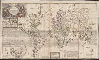
Insets: Chart of magnetic variations; North Pole.
Publisher:
Sold by H. Moll ... ,
Subject (Geographic):
World--Maps--Early works to 1800
Subject (Topic):
World maps--Early works to 1800
Found in:
Beinecke Rare Book and Manuscript Library > A new and correct map of the whole world ... / by Herman Moll ...
Published / Created:
1719
Call Number:
11 1719B
Container / Volume:
BRBL_00004
Image Count:
1
Resource Type:
Maps, Atlases & Globes
Description:
Insets: Chart of magnetic variations; North Pole.
Publisher:
Sold by H. Moll ... I. King ... Printed for John Bowles ... Tho. Bowles ... ,
Subject (Geographic):
World--Maps--Early works to 1800
Subject (Topic):
World maps--Early works to 1800
Found in:
Beinecke Rare Book and Manuscript Library > A new and correct map of the whole world ... / by Herman Moll ...
Creator:
Published / Created:
[after 1754]
Call Number:
11 1728
Container / Volume:
BRBL_00680
Image Count:
1
Resource Type:
Maps, Atlases & Globes
Description:
Cross collection no. 34.
Publisher:
Printed for I. Bowles ... Ca. Bowles ... and sold by [?] ... R. Sayer ... and Iohn King ...,
Subject (Name):
Bowles, Carington, 1724-1793, bookseller, Bowles, John, 1701-1779, bookseller, and Sayer, Robert, 1725-1794, bookseller
Subject (Topic):
World maps--Early works to 1800
Found in:
Beinecke Rare Book and Manuscript Library > A new and correct map of the world laid down according to the newest discoveries and from the most exact observations / [cartographic material] / by Herman Moll, geographer.
Creator:
Published / Created:
[1729?]
Call Number:
11 1724
Container / Volume:
BRBL_00680
Image Count:
1
Resource Type:
Maps, Atlases & Globes
Description:
Imperfect: mutilated and torn along folds, with some loss of text. Cross collection no. 33.
Publisher:
Printed for and sold by I. Bowles, map and printseller at the Black Horse in Cornhill & by T. Bowles map & print seller next to ye Chapter house in St. Paul's Church yard, and by P. Overton map & print seller near St. Dunstan's Church Fleet Street and by
Subject (Name):
Bowles, John, 1701-1779, bookseller, Bowles, Thomas, -1767, bookseller, and Overton, Philip, -1751, bookseller
Subject (Topic):
World maps--Early works to 1800
Found in:
Beinecke Rare Book and Manuscript Library > A new and correct map of the world laid down according to the newest discoveries, and from the most exact observations / [cartographic material] / by Herman Moll, geographer.
Published / Created:
1737
Call Number:
11 1737
Container / Volume:
BRBL_00681
Image Count:
1
Resource Type:
Maps, Atlases & Globes
Alternative Title:
New and correct map of the world
Description:
Contains two hemispheres, with text on Newton's theory of tides and 2 smaller hemispheres of constellations at top, and ill. of the moon and other planets at middle and bottom.
Publisher:
Printed for and sold by Geo. Foster ....,
Subject (Name):
Foster, George, fl. 1737-1739, bookseller
Subject (Topic):
World maps--Early works to 1800
Found in:
Beinecke Rare Book and Manuscript Library > A new and correct map of ye world [cartographic material] : laid down according to ye latest and best observations : to which is added several curious discourses on the tides, trade winds & monsoons ...
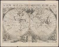
Creator:
Published / Created:
1726 or 1738]
Call Number:
11 1701
Container / Volume:
BRBL_00680
Image Count:
1
Resource Type:
Maps, Atlases & Globes
Description:
"Dedicated to His Highness William Duke of Gloucester."
Publisher:
s.n.,
Subject (Name):
Burghers, M and Wells, Edward, 1667-1727. New sett of maps both of antient and present geography
Subject (Topic):
World maps--Early works to 1800
Found in:
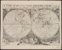
Beinecke Rare Book and Manuscript Library > A new map of the terraqueous globe : according to the ancient discoveries and most general divisions of it into continents and oceans.
Creator:
Published / Created:
1726 or 1738]
Call Number:
11 1701A
Container / Volume:
BRBL_00680
Image Count:
1
Resource Type:
Maps, Atlases & Globes
Description:
"Dedicated to His Highness William Duke of Gloucester."
Publisher:
s.n.,
Subject (Name):
Benton, Andrew Arthur--Ownership, Burghers, M, and Wells, Edward, 1667-1727. New sett of maps both of antient and present geography
Subject (Topic):
World maps--Early works to 1800
Found in:
Beinecke Rare Book and Manuscript Library > A new map of the terraqueous globe : according to the latest discoveries and most general divisions of it into continents and oceans.
Branch:v1.68.6 ,Deployed:2025-07-02T08:09:31-04:00