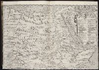
John Huighen van Linschoten, his Discours of Voyages into ye Easte & West Indies
Image Count:
1
Description:
[Scale ca. 1:14,000,000]., Bound in following p. 214., Map folded irregularly., and Map has small tear at bottom fold in center outside frame of map.
Subject (Geographic):
Africa, East --Maps, Egypt --Maps --Early works to 1800, Ethiopia --Maps --Early works to 1800, Mediterranean Sea --Maps --Early works to 1800, Nile River --Maps --Early works to 1800, and Tigris River Valley
Subject (Topic):
Voyages and travels --Early works to 1800
Collection Created:
[London] : Printed at London by [John Windet for] Iohn Wolfe, printer to ye Honorable Cittie of London, [1598]
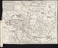
Forty-two new maps of Asia, Africa, and America ... : all engrav’d, according to the latest
Image Count:
1
Description:
In pencil on verso: 42. and Table of contents for maps 2-20 in section "America" misnumbered.
Subject (Geographic):
Afghanistan --Maps, Egypt --Maps --Early works to 1800, Greece --Maps --Early works to 1800, India --Maps, Iran --Maps --Early works to 1800, Iraq --Maps, Kazakhstan --Maps, Libya --Maps, Pakistan --Maps, Russia --Maps --Early works to 1800, Saudi Arabia --Maps, and Turkey --Maps
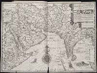
Navigatio ac itinerarivm Iohannis Hvgonis Linscotani in Orientalem sive Lvsitanorvm Indiam
Image Count:
1
Description:
[Scale ca. 1:13,500,000]., Bound in following page 12., Map has significant tear along bottom center fold and one tear at bottom left portion., and Some ink from place names have bled through to the verso.
Subject (Geographic):
Afghanistan --Maps, Egypt --Maps --Early works to 1800, India --Maps, Iran --Maps --Early works to 1800, Iraq --Maps, Pakistan --Maps, and Saudi Arabia --Maps
Subject (Name):
Claesz, Cornelis, ca. 1546-1609, publisher, Elzevier, Gillis, bookseller, Hendricksz, Aelbrecht, fl. 1573-1605, printer, and Langren, Arnold Florent van, 1580-1644
Subject (Topic):
Voyages and travels --Early works to 1800
Collection Created:
Hagae-Comitis : Ex officina Alberti Henrici, impensis authoris & Cornelii Nicolai, prostantque apud Aegidium Elseuirum, anno 1599
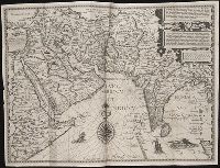
Nauigatio ac itinerarium Iohannis Hugonis Linscotani in Orientalem siue Lusitanorum Indiam
Image Count:
1
Description:
[Scale ca. 1:13,500,000]., Bound in following page 14., In pencil on middle left panel of left verso: 13-1., In pencil on middle left panel of right verso: 13., and Map has small tear along top center fold.
Subject (Geographic):
Afghanistan --Maps, Egypt --Maps --Early works to 1800, India --Maps, Iran --Maps --Early works to 1800, Iraq --Maps, Pakistan --Maps, and Saudi Arabia --Maps
Subject (Name):
Claesz, Cornelis, ca. 1546-1609, publisher, Elzevier, Gillis, bookseller, and Hendricksz, Aelbrecht, fl. 1573-1605, printer
Subject (Topic):
Voyages and travels --Early works to 1800
Collection Created:
Hagae-Comitis : Ex officina Alberti Henrici, impensis authoris & Cornelii Nicolai, prostantque apud Aegidium Elseuirum, anno 1599
Ferro meridian., No. 38 of 43 maps bound together in composite atlas., Relief shown by hachures., Scale [1:1,750,000]., and Shows rivers and settlements.
Subject (Geographic):
Egypt --Maps --Early works to 1800 and Nile River --Maps --Early works to 1800
Broeck, Crispin van den, 1524-ca. 1591 Visscher, Nicolaes, 1618-1679
Published / Created:
[ca. 1660]
Call Number:
1983 Folio 19
Collection Title:
[Atlas factice of 96 maps by Blaeu, Visscher, Jansson, Hondius and others]
Image Count:
2
Alternative Title:
Armenia Maior and Asia et Armenia Minor
Description:
Imperfect: illustrations at top cut-out and replaced with ms. titles "Asia et Armenia minor" (upper left) and "Armenia minor" (in upper right); torn along fold and at left edge, with some loss of text. Sheet measures 32 x 47.8 cm. Reinforced along edges with printed waste. No. 85 of 92 maps bound together. and Numbered 91 on verso.
Publisher:
[Nicolaes Visscher]
Subject (Geographic):
Armenia --Maps --Early works to 1800, Assyria --Maps, Egypt --Maps --Early works to 1800, Middle east --Maps --Early works to 1800, Palestine --Geography --Maps --Early works to 1800, Saudi Arabia --Maps, Syria --Maps, and Turkey --Maps
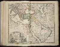
Hase, Johann Matthias, 1684-1742 Homann Erben (Firm) Homann, Johann Baptist, 1663-1724
Published / Created:
[1737]
Call Number:
1983 Folio 23
Collection Title:
[Atlas factice of 50 maps, primarily by Johann Baptist Homann and/or issued by the Homann Erben
Image Count:
1
Alternative Title:
Tabula ex novissimus ad mentem de L'Islii, inprimis vero celeberrimi geographi Dni. I.M. Hasii, Prof. Vitemb. delineata a. 1737
Description:
Number 13 of 50 works bound together.
Publisher:
[Homann Erben]
Subject (Geographic):
Balkan Peninsula --Maps --Early works to 1800, Egypt --Maps --Early works to 1800, Libya --Maps --Early works to 1800, and Middle east --Maps --Early works to 1800
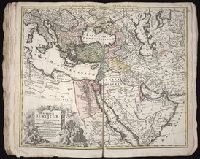
Hase, Johann Matthias, 1684-1742 Homann Erben (Firm) Homann, Johann Baptist, 1663-1724
Published / Created:
1737
Call Number:
1975 Folio 31
Collection Title:
[Atlas factice of 42 maps, produced by the Homann Erben firm]
Image Count:
1
Alternative Title:
Tabula ex novissimus ad mentem de L’Islii, inprimis vero celeberrimi geographi Dni. I.M. Hasii, Prof. Vitemb. delineata a. 1737
Publisher:
Homann Erben
Subject (Geographic):
Balkan Peninsula --Maps --Early works to 1800, Egypt --Maps --Early works to 1800, Libya --Maps --Early works to 1800, and Middle east --Maps --Early works to 1800