Skip to search
Skip to main content
Skip to first result
Search
You Searched For
Subject (Topic)
Maps
Search Results
Creator:
Published / Created:
[1717]
Call Number:
1973 Folio 18
Image Count:
1
Alternative Title:
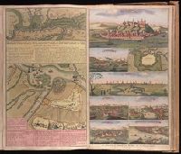
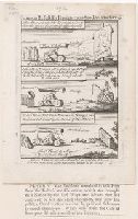
Accurate aftekening hoe de twee Legers geleegen hebben voor Belgrado, ent bomberderen en kanonneeren op malkanderen van den 2 tot den 14 Augustus anno 1717
Description:
BEIN 1973 Folio 18: Backed with paper. Ms. no. in upper right corner [illegible due to trimming]. Sheet measures 53.8 x 62.4 cm. No. 74 of 87 maps bound together.
Publisher:
By Gerard van Keulen, aen de Nieuwen Brugh
Subject (Geographic):
Serbia
Subject (Topic):
Austro-Turkish War, 1716-1718 and Maps
Found in:
Beinecke Rare Book and Manuscript Library > Attaque der Turkse galeyen en saiken, op de 2 keyserlyke oorlog scheepen op den 9 July voor gevallen op den Donau [cartographic material].
Creator:
Published / Created:
[ca. 1702?]
Call Number:
1973 Folio 18
Image Count:
1
Description:
BEIN 1973 Folio 18: Backed with paper. Ms. no. "61" in upper right-hand corner. Sheet measures 53.1 x 62.3 cm. No. 56 of 87 maps bound together.
Publisher:
Ger. et Leo. Valk
Subject (Geographic):
Orléanais (France)
Subject (Topic):
Maps
Found in:
Beinecke Rare Book and Manuscript Library > Aurelianensis Praefectura Generalis, in qua partiliter discriminati superiores Ducatus Cenomanensis ... [cartographic material]
Creator:
Published / Created:
ca. 1702]
Call Number:
1973 Folio 18
Image Count:
1
Description:
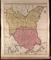
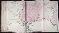
BEIN 1973 Folio 18: Backed with paper. Ms. no. "82" in upper left corner. Sheet measures 62.5 x 53.7 cm. No. 76 of 87 maps bound together.
Publisher:
Gerard Valk
Subject (Geographic):
Bulgaria, Romania, and Turkey
Subject (Topic):
Maps
Found in:
Beinecke Rare Book and Manuscript Library > Bulgaria et Romania divisa in singulares sangiacatus Silistriam, Nicopolin, Bodinum, Sardiam, Bysantium, Kirkeliam et Gallipolin, una cum finitimis regionibus Valachia, Servia etc. / [cartographic material]
Creator:
Published / Created:
Novembre MDCCLV [1755]
Call Number:
2003 Folio 85
Image Count:
1
Resource Type:
cartographic image
Description:
BEIN 2003 Folio 85: No. 3 of 45 maps bound together with binder's spine title: Atlas of America; ms. table of contents. Bookplate: Robinson. Bookplate of Paul Mellon.
Publisher:
Chez l'auteur, aux galeries du Louvre
Subject (Geographic):
North America, Louisiana, and Canada
Subject (Topic):
Maps
Found in:
Beinecke Rare Book and Manuscript Library > Canada, Louisiane et terres angloises
Published / Created:
[1756]
Call Number:
756.00.00.49
Image Count:
1
Resource Type:
still image
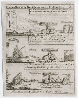
Alternative Title:
Cannon refused by foreigners as too destructive
Description:
Title etched at top of plate.
Publisher:
publisher not identified
Subject (Name):
Holland, Henry Fox, Baron, 1705-1774
Subject (Topic):
Britannia (Symbolic character), Cannons, Maps, Money, Taxes, and Bibles
Found in:
Lewis Walpole Library > Cannon refus'd by foreigners as too destructive [graphic].
Published / Created:
[1756]
Call Number:
756.00.00.57
Image Count:
1
Resource Type:
still image
Alternative Title:
Cannon refused by foreigners as too destructive
Description:
Title etched at top of plate.
Publisher:
To be had at the Acorn, facing Hungerford Market in the Strand
Subject (Name):
Holland, Henry Fox, Baron, 1705-1774
Subject (Topic):
Britannia (Symbolic character), Cannons, Maps, Money, Taxes, and Bibles
Found in:
Lewis Walpole Library > Cannon refus'd by foreigners as too destructive [graphic].
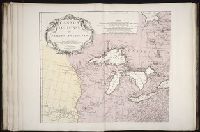
Creator:
Published / Created:
1752
Call Number:
2003 Folio 85
Image Count:
1
Resource Type:
cartographic image
Description:
BEIN 2003 Folio 85: No. 25 of 45 maps bound together with binder's spine title: Atlas of America; ms. table of contents. Bookplate: Robinson. Bookplate of Paul Mellon.
Publisher:
Jean Baptiste Bourguignon d'Anville
Subject (Geographic):
Louisiana, Southern States, and Gulf of Mexico
Subject (Topic):
Maps and Nautical charts
Found in:
Beinecke Rare Book and Manuscript Library > Carte de la Louisiane
Creator:
Published / Created:
[1781]
Call Number:
Art Storage 994
Image Count:
1
Resource Type:
cartographic image
Description:
Relief shown by hachures.
Subject (Geographic):
Virginia and United States
Subject (Name):
Lafayette, Marie Joseph Paul Yves Roch Gilbert Du Motier, marquis de, 1757-1834.
Subject (Topic):
Maps and History
Found in:
Beinecke Rare Book and Manuscript Library > Carte de la campagne en Virginie du major genéral Mis. de la Fayette ou se trouvent les camps et marches ainsy que ceux du lieutent. général Lord Cornwallis en 1781
Creator:
Published / Created:
[1775?]
Call Number:
27 1775
Image Count:
1
Resource Type:
cartographic image
Description:
Depth shown by soundings.
Publisher:
Chez Demonville
Subject (Geographic):
Sunda Strait (Indonesia), Indonesia, and Sunda Strait.
Subject (Topic):
Maps and Nautical charts
Found in:
Beinecke Rare Book and Manuscript Library > Carte pour aller du détroit de la Sonde ou de Batavia au détroit de Banca
Creator:
Published / Created:
ca. 1702?]
Call Number:
1973 Folio 18
Image Count:
1
Description:
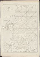
BEIN 1973 Folio 18: Backed with paper. Ms. no. "34" in upper left-hand corner. Sheet measures 53.6 x 62.9 cm. No. 33 of 87 maps bound together.
Publisher:
Gerard Valk
Subject (Geographic):
Franconia (Germany)
Subject (Topic):
Maps
Found in:
Beinecke Rare Book and Manuscript Library > Circulus Franconicus divisa in Ducatus Coburgi, Franconiae, et Episcopatus Wurtzburgi, Bambergae, et Stadii., Marchionatus Culmbachii, et Onspachii, Comitatus Hennenbergae, Rheineci, Werthemii, Erpachia, Limburgi, Hollae, Suartenburgi, et Castellae / [cartographic material]