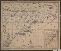
Appears in Speed's The theatre of the Empire of Great Britaine., English on recto, verso., Hand col. Sheet measures 41.7 x 54.4 cm., Oriented west., Relief shown pictorially., and Verso: Page nos. 43-44; titles "The description of Mary-land", "The descr
Publisher:
Sold by Thomas Basset in Fleetstreet and Richard Chiswell in St. Pauls Church yard,
Subject (Geographic):
Maryland--History--Colonial period, ca. 1600-1775--Maps--Early works to 1800, Maryland--Maps--Early works to 1800, Virginia--History--Colonial period, ca. 1600-1775--Maps--Early works t, and Virginia--Maps--Early works to 1800
Subject (Name):
Bassett, Thomas, bookseller, Chiswell, Richard, Lamb, Francis, engraver, and Speed, John, 1552?-1629. Theatre of the Empire of Great Britaine
Accompanied by broadside text entitled: A description of New-England (4 p. ; 46 cm.)., Appears in author's Atlas maritimus, or, The sea-atlas, 1675., and Covers New England from the Penobscot River (Maine) region in the east to the Hudson River (New York) regio
Publisher:
And are to bee sold at his shop at the Hermitage in Wapping and by Iohn Hills in Exchange Alley in Cornhill,
Subject (Geographic):
New England--Maps--Early works to 1800
Subject (Name):
Hills, John, 17th cent and Seller, John, fl. 1658-1698. Atlas martitimus
Map of Virginia, Maryland, New Jersey, New-York & New England and Mapp of New England
Description:
"Separate publication ca. 1673 ... Various dates have been assigned to the map, from 1673 to 1685" (McCorkle 33)., Inset: "A mapp of New England"., Relief shown p, and Reproduced in McCorkle, p. 33. Verso: Ink ms. annotations; numbered "57" in ink ms.
Publisher:
By John Thornton ... and by Robert Greene ... ,
Subject (Geographic):
Middle Atlantic States--Maps--Early works to 1800, New England--Maps--Early works to 1800, and New York (State)--Maps--Early works to 1800
Map of all the world in two hemispheres in which are exactly described all the parts of the earth and seas
Description:
Dedicated To the most serene and most sacred majesty of Charles II ..., Described by Sanson ; corrected and amended by William Berry., Includes coat of arms and decorative cartouche containing dedication., No. 1 of 69 maps bound together in composite atlas., Prime meridian: Ferro., Relief shown pictorially., Scale [ca. 1:60 000 000]., and Shows California as an island.
Publisher:
Sold by William Berry at ye sign of the globe between Charing-Cross and White-Hall
Subject (Geographic):
Eastern Hemisphere --Maps --Early works to 1800 and Western Hemisphere --Maps --Early works to 1800
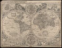
New and accurate map of the world and New and accvrat map of the world
Description:
Appeared in Speed's A prospect of the most famous parts of the world... London...1676., Imperfect: torn along fold, with some loss of text. Mounted on cardboard. Cross collection no. 18., Includes astrological charts, allegorical figures representing the elements, and portraits in medallions of explorers Sir Francis Drake, Ferdinand Magellan, Oliverus van der Noort and Thomas Candish., Relief shown pictorially., Scale measured at center of hemisphere., Shows California as an island., and This map is state 4, the last state published--Cf. Shirley R.W. Mapping of the world, 317.
Publisher:
Are to be sold by Tho. Bassett ... and Ric. Chiswell ...,
Subject (Name):
Bassett, Thomas, bookseller, bookseller, Chiswell, Richard, bookseller, and Speed, John, 1552?-1629. Prospect of the most famous parts of the world
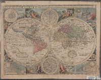
"Are to be sold in Pops- head Alle by Geor. Humble"., Cross collection no. 15., Double hemisphere, with smaller celestial hemispheres and astronomical diagram., From: A prospect of the most famous parts of the world... London...1627., Shows California as an island., and Text on verso: "The generall description of the world".
Publisher:
George Humble,
Subject (Name):
Humble, George, -1640. and Speed, John, 1552?-1629. Prospect of the most famous parts of the world.
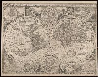
"Are to be sold by Tho: Bassett in Fleet Street and Ric: Chiswell in St. Pauls Church yard", Double hemisphere, with smaller celestial hemispheres and astronomical diagram., From: A prospect of the most famous parts of the world... London...1676., Mounted on linen, text on verso: "The generall description of the world" is still visible. Cross collection no. 17., Shows California as an island., and This map is state 4, the last state published.
Publisher:
Sold by Tho. Bassett and Ric. Chiswell,
Subject (Name):
Bassett, Thomas, bookseller., Chiswell, Richard., and Speed, John, 1552?-1629. Prospect of the most famous parts of the world.