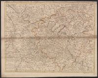
Appears in John Senex's A new general atlas., Imperfect: mutilated along folds, with some loss of text. Hand col. Mounted in linen. Sheet measures 53 x 68 cm. Cross Collection no. 89., London meridian., Relief shown pictorially and by hachures., and Shows boundaries, rivers, roads, forests and settlements.
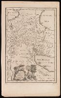
Detached from the American geography ... / by Jedidiah Morse. -- Second edition. London : Published by John Stockdale, 1792., Longitude west from London., NcD., and Relief shown by hachures.
Publisher:
Publish'd by John Stockdale,
Subject (Geographic):
South Atlantic States--Maps--Early works to 1800. and United States--South Atlantic States
Subject (Name):
Harrison, William, approximately 1750-1803, Morse, Jedidiah, 1761-1826, and Stockdale, John, 1749?-1814
From Thomas Stackhouse's New history of the Holy Bible (London, 1752)., In lower left corner, "Pl. 4"; in lower right corner, "page 26.", and Relief shown pictorially.
Publisher:
[Printed for John Hinton],
Subject (Geographic):
Middle East--Historical geography--Maps--Early works to 1800. and Middle East--Maps--Early works to 1800.
Subject (Name):
Hinton, John, -1781 and Stackhouse, Thomas, approximately 1680-1752. New history of the Holy Bible.
Navigantium atque itinerantium bibliotheca ; Or, A complete collection of voyages and travels
Image Count:
1
Resource Type:
Maps, Atlases & Globes
Alternative Title:
New and accurate map of China
Description:
From: Navigantium atque itinerantium bibliotheca, or, A complete collection of voyages and travels / originally published in two volumes in folio, by John Harris. London : Printed for T. Osborne [and others], 1764., In upper right margin: Vol. II. Page 961., Map of China showing provincial divisions. Relief shown pictorially., Prime meridian: London., and Watermark.
Publisher:
[Printed for T. Osborne],
Subject (Geographic):
China--Maps--Early works to 1800.
Subject (Name):
Harris, John, 1667?-1719. Navigantium atque itinerantium bibliotheca.
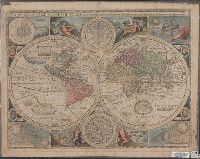
New and accurate map of the world and New and accvrat map of the world
Description:
Appeared in Speed's A prospect of the most famous parts of the world... London...1676., Imperfect: torn along fold, with some loss of text. Mounted on cardboard. Cross collection no. 18., Includes astrological charts, allegorical figures representing the elements, and portraits in medallions of explorers Sir Francis Drake, Ferdinand Magellan, Oliverus van der Noort and Thomas Candish., Relief shown pictorially., Scale measured at center of hemisphere., Shows California as an island., and This map is state 4, the last state published--Cf. Shirley R.W. Mapping of the world, 317.
Publisher:
Are to be sold by Tho. Bassett ... and Ric. Chiswell ...,
Subject (Name):
Bassett, Thomas, bookseller, bookseller, Chiswell, Richard, bookseller, and Speed, John, 1552?-1629. Prospect of the most famous parts of the world