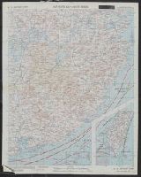
Shows roads, boundaries, railroads, power transmission lines, cities, towns, rivers, swamps, reefs and shoals.
Alternative Title:
AAF cloth map. and Asiatic series
Description:
"Officers using this chart will mark hereon corrections and addition, Aviator's survival map, printed on cloth., No. 34. Southeast China -- no. 35. Northeast China., Relief shown by hachures and spot heights (China)., and Shows wind directions and ocean currents.
Publisher:
Army Map Service, U.S. Army,
Subject (Geographic):
China, Southeast--Maps and Southeast Asia--Maps
Subject (Name):
United States. Aeronautical Chart Service and United States. Army Air Forces
Subject (Topic):
Military maps, Ocean currents--China--Maps, and Winds--China--Maps
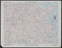
Shows roads, boundaries, railroads, power transmission lines, cities, towns, rivers, swamps, reefs and shoals.
Alternative Title:
AAF cloth map. and Asiatic series
Description:
"Officers using this chart will mark hereon corrections and additions which come to their attention and mail dire, No. 34. Southeast China -- no. 35. Northeast China., Originally issued as a restricted map., and Relief shown by hachures and spot heights (China).
Publisher:
Army Map Service, U.S. Army,
Subject (Geographic):
China, Southeast--Maps and Southeast Asia--Maps
Subject (Name):
United States. Aeronautical Chart Service and United States. Army Air Forces
Subject (Topic):
Military maps, Ocean currents--China--Maps, and Winds--China--Maps
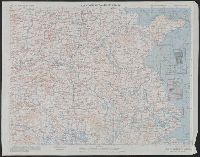
Shows roads, boundaries, railroads, power transmission lines, cities, towns, rivers, swamps, reefs and shoals.
Alternative Title:
AAF cloth map. and Asiatic series
Description:
"Officers using this chart will mark hereon corrections and additions which come to their attention and mail direct to 'Aeronautical Chart Service, Headquarters Army Air Forces, Washington, D.C.'"--Lower and Relief shown by hachures and spot heights (China).
Publisher:
Army Map Service, U.S. Army,
Subject (Geographic):
China, Southeast--Maps and Southeast Asia--Maps
Subject (Name):
United States. Aeronautical Chart Service and United States. Army Air Forces
Subject (Topic):
Military maps, Ocean currents--China--Maps, and Winds--China--Maps
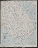
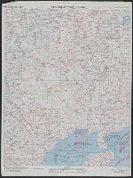
Shows roads, boundaries, railroads, power transmission lines, cities, towns, rivers, marsh, open water areas.
Alternative Title:
AAF cloth map. and Asiatic series
Description:
"Officers using this chart will mark her, Materials and list of maps in series from "US cloth maps of World War II" website., Originally issued as a restricted map., Relief shown by hachures and spot heights (China)., and Shows wind directions and ocean currents.
Publisher:
Army Map Service, U.S. Army,
Subject (Geographic):
China--Maps and Southeast Asia--Maps
Subject (Name):
United States. Aeronautical Chart Service and United States. Army Air Forces
Subject (Topic):
Military maps, Ocean currents--China--Maps, Ocean Currents--Southeast Asia--Maps, Winds--China--Maps, and Winds--Southeast Asia--Maps
Shows roads, boundaries, railroads, power transmission lines, cities, towns, rivers, marsh, open water areas.
Alternative Title:
AAF cloth map. and Asiatic series
Description:
"Officers using this chart will mark hereon corrections and additions which come t, Materials and list of maps in series from "US cloth maps of World War II" website., Originally issued as a restricted map., and Relief shown by hachures and spot heights (China).
Publisher:
Army Map Service, U.S. Army,
Subject (Geographic):
China--Maps and Southeast Asia--Maps
Subject (Name):
United States. Aeronautical Chart Service and United States. Army Air Forces
Subject (Topic):
Military maps, Ocean currents--China--Maps, Ocean Currents--Southeast Asia--Maps, Winds--China--Maps, and Winds--Southeast Asia--Maps
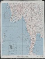
Shows roads, boundaries, railroads, power transmission lines, cities, towns, rivers, marsh, open water areas.
Alternative Title:
AAF cloth map. and Asiatic series
Description:
"Officers using this chart will mark hereon corrections and additions which come to their attention and mail direct to 'Aeronautical Chart Service, Headquarters Army Air Forces, Washington, D.C.'"--Lower left margin of each sheet. and Aviator's survival map,
Publisher:
Army Map Service, U.S. Army,
Subject (Geographic):
Burma--Maps
Subject (Name):
United States. Aeronautical Chart Service and United States. Army Air Forces
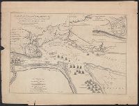
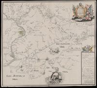
A view of the action gained by the English Sepr. 13 1759 near Quebec.
Description:
Includes inscription to William Pitt from Thos. Jefferys, Insets: Part of the upper river of St. Laurence -- A view of the action gained by the English Sepr. 13 1759 near Quebec, brought from there by an officer of distinction., and Oriented with north to upper
Publisher:
Thos. Jefferys?,
Subject (Geographic):
Saint Lawrence River Estuary (Québec)--History, Military--Maps
A view of the action gained by the English Sepr. 13 1759 near Quebec.
Description:
Insets: [1.] Part of the upper river of St. Laurence -- [2.] A view of the action gained by the English Sepr. 13, 1759, near Quebec, brought from thence by an officer of distinction., Oriented with north to upper right, and Relief shown by hachures and shading.
Publisher:
Published by Thos. Jefferys, Geographer to his Royal Highness the Prince of Wales, near Charing Cross,
Subject (Geographic):
Saint Lawrence River Estuary (Québec)--History, Military--Maps
Subject (Name):
Jefferys, Thomas, d. 1771 and Pitt, William, Earl of Chatham, 1708-1778, dedicatee