"Sold by Wm. Herbert on London Bridge & Robt. Sayer over against Fetter Lane in Fleet Street.", Includes inset showing North America from Hudson's Bay to Panama., Library copy shows damage in top and bottom margins., and Relief shown pictorially.
Publisher:
Sold by Wm. Herbert ...,
Subject (Geographic):
North America--Maps--Early works to 1800
Subject (Name):
Sayer, Robert, 1725-1794 and Society of Anti-Gallicans
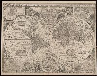
"Are to be sold by Tho: Bassett in Fleet Street and Ric: Chiswell in St. Pauls Church yard", Double hemisphere, with smaller celestial hemispheres and astronomical diagram., From: A prospect of the most famous parts of the world... London...1676., Mounted on linen, text on verso: "The generall description of the world" is still visible. Cross collection no. 17., Shows California as an island., and This map is state 4, the last state published.
Publisher:
Sold by Tho. Bassett and Ric. Chiswell,
Subject (Name):
Bassett, Thomas, bookseller., Chiswell, Richard., and Speed, John, 1552?-1629. Prospect of the most famous parts of the world.
Imperfect: mutilated and torn along folds, with some loss of text. Cross collection no. 33., Includes dedication within ornamental cartouche, "To His Most Sacred Majesty George IId by the grace of God King of Great Britain France & Ireland Defender of the Faith &c. this map is humbly dedicated.", Includes text., Insets: The Ptolemean systeme -- The North Pole -- The Copernican systeme -- Mercury -- The appearance of the Sun -- Venus -- Mars -- Saturn -- Jupiter -- The appearance of the Moon., Prime meridian: Ferro., Relief shown pictorially., Scale measured at center of hemisphere., Shows California as an island., and Shows the world as a double hemisphere, annual winds and wind directions, solar equinox and ecliptic, and noted corrections over previous geography.
Publisher:
Printed for and sold by I. Bowles, map and printseller at the Black Horse in Cornhill & by T. Bowles map & print seller next to ye Chapter house in St. Paul's Church yard, and by P. Overton map & print seller near St. Dunstan's Church Fleet Street and by
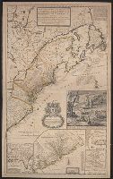
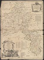
[South part of Carolina, and the east part of Florida], Draught of ye town and harbour of Charles-town, Map of the improved part of Carolina with the settlements, Map of the principal part of North America, and View of ye industry of ye beavers of Canada
Description:
Dedication: "To the honourable Walter Dowglass ... by ... Herman Moll ... ", Hand col. On sheet 103 x 64 cm. Recto: Numbered "11" in ink ms. Verso: Stamped "Yale Horace Brown 1900S"., and Similar to description in Tooley, p. 87, map 55, 1715 (a).
Publisher:
Sold by H. Moll over against Deverux Court in the Strand,
Subject (Geographic):
France--Colonies--America--Maps--Ear, Great Britain--Colonies--America--Maps--Early works to 1800, North America--Maps--Early works to 1800, and United States--History--Colonial period, ca. 1600-1775--Maps--Early works to 1800
Subject (Name):
Dowglass, Walter, dedicatee, Moll, Herman, d. 1732, dedicator, and Moll, Herman, d. 1732, publisher
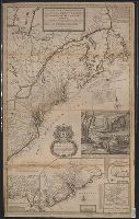
[South part of Carolina, and the east part of Florida], Draught of ye town and harbour of Charles-town, Map of the improved part of Carolina with the settlements, Map of the principal part of North America, and View of ye industry of ye beavers of Canada
Description:
Dedication: "To the honourable Walter Dowglass ... by ... Herman Moll ... ", Hand col. On sheet 104 x 64 cm. Recto: Stamped "Yale Horace Brown 1900S". Verso: Numbered "VIIIth" in ink ms.; labeled "English Dom: in N., and Publication date from Tooley.
Publisher:
Sold by H. Moll and by I. King at ye globe and ye poultrey near Stocks Market,
Subject (Geographic):
France--Colonies--America--Maps--Early works to 1800, Great Britain--Colonies--America--Maps--Early works to 1800, North America--Maps--Ear, and United States--History--Colonial period, ca. 1600-1775--Maps--Early works to 1800
Subject (Name):
Dowglass, Walter, dedicatee, King, John, fl. 1710-1749, publisher, and Moll, Herman, d. 1732, publisher
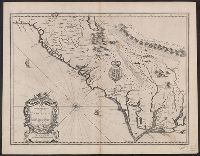
English on recto, verso., From John Speed's Theatre of the empire of Great Britain ... London : Printed for Thomas Basset ... and Richard Chiswel ..., 1676., Oriented west., Relief shown pictorially., Sheet measures 43.5 x 56. Cross Collection no. 219., and Verso: Page numbers "50", "49"; titles "The description of Carolina", "The description of Florida"; signature 2B.
Publisher:
Sold by Tho: Basset in Fleetstreet and Ric. Chiswell in St. Pauls Churchyard,
Subject (Geographic):
North Carolina--History--Colonial period, ca. 1600-1775--Maps--Early works to 1800, North Carolina--Maps--Early works to 1800, South Carol, and South Carolina--History--Colonial period, ca. 1600-1775--Maps--Early works to 1800
Subject (Name):
Bassett, Thomas, bookseller, Chiswell, Richard, Lamb, Francis, engraver, and Speed, John, 1552?-1629. Theatre of the Empire of Great Britaine