Skip to search
Skip to main content
Skip to first result
Search
You Searched For
Resource Type
Maps, Atlases & Globes
Creator
Great Britain. War Office. General Staff. Geographical Section
Publication Place
Washington :
New Search
Search Results
Creator:
Published / Created:
1943
Call Number:
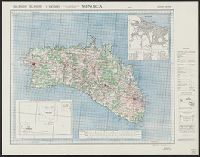
3969 M52 1943
Container / Volume:
BRBL_00194
Image Count:
1
Resource Type:
Maps, Atlases & Globes
Alternative Title:
Great Britain. War Office. General Staff. Geographical Section. G.S.G.S. ; 4134., GSGS (Series) ; 4134., and Its [G.S.G.S.] ; 4134
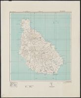
Description:
"Contour interval 50 metres.", "N3945-E345/25x40.", Five classes of roads or paths, three classes of railroads, and areas of woods and intensive culivation are shown., In upper margin: Balearic islands 1:100,000 ..., and Insets: Mahon [with index]--Index to adjoi
Publisher:
Army Map Service, U.S. Army,
Subject (Geographic):
Minorca (Spain)--Maps
Subject (Name):
United States. Army Map Service
Found in:
Beinecke Rare Book and Manuscript Library > Menorca [cartographic material].
Creator:
Published / Created:
1945
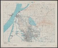
Call Number:
56 N15 1945
Container / Volume:
BRBL_00297
Image Count:
1
Resource Type:
Maps, Atlases & Globes
Alternative Title:
[U.S. Army Map Service. A.M.S. ; L901], GSGS (Series) ; 3831., Its [G.S.G.S.] ; 3831, and Series (Standard map series designation system) ; L901.
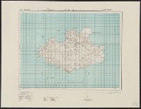
Description:
"5-45.", "Contour interval 10 metres.", At head of title: China., Four classes of roads and paths are shown; some streets and buildings are named; areas of vegetation and cultivation are shown., and Military grid.
Publisher:
Army Map Service,
Subject (Geographic):
Nanjing (Jiangsu Sheng, China)--Maps
Subject (Name):
United States. Army Map Service
Found in:
Beinecke Rare Book and Manuscript Library > Nanking [cartographic material].
Creator:
Published / Created:
1943
Call Number:
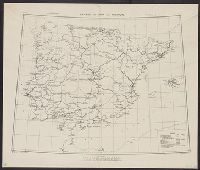
39gme 1943
Container / Volume:
BRBL_00192
Image Count:
1
Resource Type:
Maps, Atlases & Globes
Alternative Title:
Geographical Section, General Staff ; no. 4170 and GSGS (Series) ; 4170.
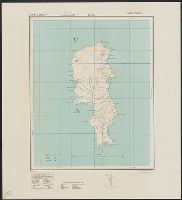
Description:
In upper margin: C. B. 4096 D ... March 1941. and Railroads are classified as steam or electric, double or single track, and broad or other gauge.
Publisher:
Army Map Service, U. S. Army,
Subject (Topic):
Maps--Portugal--1943, Maps--Spain--1943, Railroads--Portugal--Maps, and Railroads--Spain--Maps
Found in:
Beinecke Rare Book and Manuscript Library > Railways in Spain and Portugal [cartographic material].
Creator:
Published / Created:
1943
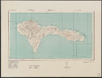
Call Number:
213 Sa61 1943
Container / Volume:
BRBL_00015
Image Count:
1
Resource Type:
Maps, Atlases & Globes
Alternative Title:
G.S.,G.G., ; no. 4115 and GSGS (Series) ; 4115.
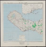
Description:
Elevations shown by form lines and spot heights., In upper margin: Cape Verde ids ..., and Military grid.
Publisher:
Army Map Service, U.S. Army,
Subject (Geographic):
São Nicolau Island (Cape Verde)--Maps, Topographic
Found in:
Beinecke Rare Book and Manuscript Library > S. Nicolau / drawn at War Office, 1940, from a Portuguese map of 1929.
Creator:
Published / Created:
1943
Call Number:
213 Sa611 1943
Image Count:
1
Resource Type:
Maps, Atlases & Globes
Alternative Title:
G.S.,G.S. 4116. and GSGS (Series) ; 4116.
Description:
In upper margin: Cape Verde Ids., Index map cataloged with G.S.G.S. 4111., Military grid., and Relief shown by form lines and contours.
Publisher:
Army Map Service,
Subject (Geographic):
São Tiago Island (Cape Verde)--Maps
Found in:
Beinecke Rare Book and Manuscript Library > S. Tiago / drawn at War Office, 1940, from a Portuguese map of 1932
Creator:
Published / Created:
1943
Call Number:
213 Sa62 1943
Image Count:
1
Resource Type:
Maps, Atlases & Globes
Alternative Title:
G. S. G. S., ; 4119 and GSGS (Series) ; 4119.
Description:
Elevations shown by form lines and spot heights., In upper margin: Cape Verde Ids. ..., Index map cataloged with G. S. G. S. 4117., and Military grid.
Publisher:
Army Map Service, U.S. Army,
Subject (Geographic):
São Vicente Island (Cape Verde)--Maps, Topographic
Found in:
Beinecke Rare Book and Manuscript Library > S. Vicente : drawn at War Office, 1940, from a Portuguese map of 1932.
Creator:
Published / Created:
1943
Call Number:
213 Sa31 1943
Container / Volume:
BRBL_00015
Image Count:
1
Resource Type:
Maps, Atlases & Globes
Alternative Title:
G.S.,G.S. ; 4114 and GSGS (Series) ; 4114.
Description:
Elevations shown by form lines and spot heights., In upper margin: Cape Verde ids ..., Index map cataloged with G. S. G. S. 4111., and Military grid.
Publisher:
Army Map Service, U.S. Army,
Subject (Geographic):
Sal (Cape Verde)--Maps, Topographic
Found in:
Beinecke Rare Book and Manuscript Library > Sal / crawn at War Office, 1940, from a Portuguese map of 1930.
Creator:
Published / Created:
1943-44.
Call Number:
212 Sa58 1944
Container / Volume:
BRBL_00014
Image Count:
1
Resource Type:
Maps, Atlases & Globes
Alternative Title:
[Series] M789, A.M.S. M789, G.S.G.S. ; no. 4124, and GSGS (Series) ; 4124.
Description:
"Contours at 25 metres interval.", East sheet, 1943., Five classes of roads or paths are shown., In upper margin: Azores 1:50,000 ..., Index map cataloged with G. S. G. S. 4122, G9132.S2 1942.G7a., Insets: Azores islands.--Ponta Delgada [on West, and Military grid.
Publisher:
Army Map Service, U. S. Army,
Subject (Geographic):
São Miguel Island (Azores)--Maps, Topographic
Found in:
Beinecke Rare Book and Manuscript Library > San Miguel island / drawn by the War Office.
Creator:
Published / Created:
1942
Call Number:
212 Sa59 1942
Container / Volume:
BRBL_00014
Image Count:
1
Resource Type:
Maps, Atlases & Globes
Alternative Title:
Geographical section, General staff. ; no. 4122 and GSGS (Series) ; 4122.
Description:
"Contours at 25 metres interval.", In upper margin: Azores 1:50,000 ..., Marginal map: Azores islands., and Military grid.
Publisher:
Army Map Service, U.S. Army,
Subject (Geographic):
Azores--Maps and Santa Maria Island (Azores)--Maps, Topographic
Found in:
Beinecke Rare Book and Manuscript Library > Santa Maria / drawn at the War Office, 1940.
Branch:v1.61.6 ,Deployed:2024-06-12T09:55:36-04:00