"Compiled in April 1947 from AMS L-902 Japan City Plans, 1:12,500." and Text, indexes to military installations, dependent housing, visitor's aids, and ill. on verso.
Great Britain. War Office. General Staff. Geographical Section
Published / Created:
1943
Call Number:
3969 M52 1943
Container / Volume:
BRBL_00194
Image Count:
1
Resource Type:
Maps, Atlases & Globes
Alternative Title:
Great Britain. War Office. General Staff. Geographical Section. G.S.G.S. ; 4134., GSGS (Series) ; 4134., and Its [G.S.G.S.] ; 4134
Description:
"Contour interval 50 metres.", "N3945-E345/25x40.", Five classes of roads or paths, three classes of railroads, and areas of woods and intensive culivation are shown., In upper margin: Balearic islands 1:100,000 ..., and Insets: Mahon [with index]--Index to adjoi
Bottom right corner: Mostaganem N355-E 003 / 2X4., In upper margin: Algeria 1:10,000 ..., Map included on index map to G.S.G.S. 4275., and Military grid.
Publisher:
Army Map Service, U.S. Army,
Subject (Geographic):
Mostaganem (Algeria)--Maps
Subject (Name):
Great Britain. War Office. General Staff. Geographical Section and United States. Army Map Service
Great Britain. War Office. General Staff. Geographical Section
Published / Created:
1945
Call Number:
56 N15 1945
Container / Volume:
BRBL_00297
Image Count:
1
Resource Type:
Maps, Atlases & Globes
Alternative Title:
[U.S. Army Map Service. A.M.S. ; L901], GSGS (Series) ; 3831., Its [G.S.G.S.] ; 3831, and Series (Standard map series designation system) ; L901.
Description:
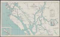
"5-45.", "Contour interval 10 metres.", At head of title: China., Four classes of roads and paths are shown; some streets and buildings are named; areas of vegetation and cultivation are shown., and Military grid.
In upper margin: Nemours 1:10,000., Map included on index map to G.S.G.S. 4275., Military grid., and Relief shown by form lines, "interval 20 feet (approximate)."
Publisher:
Army Map Service, U.S. Army,
Subject (Geographic):
Ghazaouet (Algeria)--Maps
Subject (Name):
Great Britain. War Office. General Staff. Geographical Section and United States. Army Map Service
Great Britain. War Office. General Staff. Geographical Section
Published / Created:
1945
Call Number:
56 Sh18 1945
Container / Volume:
BRBL_00297
Image Count:
1
Resource Type:
Maps, Atlases & Globes
Alternative Title:
Geographic Section General Staff ; 3789 and GSGS (Series) ; 3789.
Description:
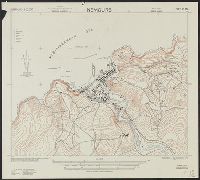
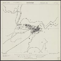
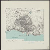
"9-45.", "Published by the War Office 1927.", At foot of map: Shanghai N3108-E12118/19., At head of map: Eastern China 1:50,000; Sheet 620/1,235., and N3108.
Geographical Section, General Staff ; 4379, GSGS (Series) ; 4379., and Sciacca
Description:
"6-43.", "From uncorrected air photographs of 1943. Fathom lines from Italian chart 173 of 1935.", "War Office, 1943.", Military grid (blue)., and Relief shown by rock drawings. Depths shown by isolines.
Publisher:
Army Map Service, U.S. Army,
Subject (Geographic):
Sciacca (Italy)--Maps
Subject (Name):
Great Britain. War Office. General Staff. Geographical Section and United States. Army Map Service
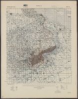
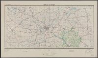
"Work Projects Administration project. Prepared under the direction of the Chief of Engineers, U.S. Army, by Engineer Reproduction Plant, the Army War College.", Coverage includes portions of Minnesota and Wisconsin., and Shows up to 7 classes of roads, 3 classes of railroads, and 4 classes of airfields.
Publisher:
Army Map Service,
Subject (Geographic):
Minnesota--Maps and Wisconsin--Maps
Subject (Name):
United States. Army Map Service and United States. Work Projects Administration
Subject (Topic):
Transportation--Minnesota--Maps and Transportation--Wisconsin--Maps