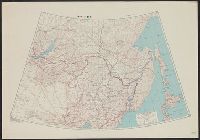
Its A.M.S. ; 5207 and Series (Standard map series designation system) ; S901.
Description:
"9-45.", "Lambert conformal conic projection.", Area covered extends from Lake Baikal to the Pacific Ocean and includes Manchuria., Elevations are shown by hachures and spot heights in meters., and Two classes of roads and five classes of railroads are shown.
Publisher:
Army Map Service,
Subject (Geographic):
Asiatic Russia--Maps, China--Maps, and Russia--Maps
Subject (Topic):
Transportation--China--Manchuria--Maps and Transportation--Russia--Maps
Its A.M.S. ; L991 and Series (Standard map series designation system) ; L991.
Description:
"Contour interval 10 meters with auxiliary contours at 5 meter and 2 1/2 meter intervals.", "Place names are transcribed according to the modified Hepburn (Romaji) system.", "Polyconic projection.", At head of title: Formosa city plans ..., and Includes "Glossary
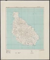
Its A.M.S. ; L991 and Series (Standard map series designation system) ; L991.
Description:
"Contour interval 10 meters.", "Place names are transcribed according to the modified Hepburn (Romaji) system.", "Polyconic projection.", At head of title: Formosa city plans ..., Includes "Glossary.", and Marginal maps and diagrams: Index to boundaries.--Coverage
Its A.M.S. ; L991 and Series (Standard map series designation system) ; S6201.
Description:
"Approximate contour interval 10 meters.", "Place names are transcribed according to the modified Hepburn (Romaji) system.", "Polyconic projection.", At head of title: Formosa city plans ..., Includes "Glossary.", and Marginal maps and diagrams: Index to boundarie
Its A.M.S. ; L991 and Series (Standard map series designation system) ; L991.
Description:
"Contour interval 10 meters.", "Place names are transcribed according to the modified Hepburn (Romaji) system.", "Polyconic projection.", In upper margin: Formosa city plans., Includes "Glossary.", Insets: Index to boundaries.--Coverage diagram., and Military grid.
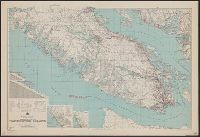
AMS ; A521, Northerly portion Vancouver Island, Series (Standard map series designation system) ; A521., and Southerly portion Vancouver Island
Description:
Map originallly published by B, North sheet contains inset of the Scott Islands., Northerly portion Vancouver Island, 1929, Map No. 2C -- Southerly portion Vancouver Island, 1938, Map No. 2A., and South sheet contains index map, location map, and mileage charts.
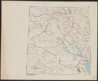
"Lambert conformal conic projection.", Elevations are shown by hachures and spot heights in meters., Includes "Glossary.", Inset shows area with detailed transportation information., and Three classes of roads or trails and three classes of railroads are shown.