Search
You Searched For
Search Results
- Creator:
- Moll, Herman, -1732
- Published / Created:
- [1729?]
- Call Number:
- 11 1724
- Container / Volume:
- BRBL_00680
- Image Count:
- 1
- Resource Type:
- Maps, Atlases & Globes
- Found in:
- Beinecke Rare Book and Manuscript Library > A new and correct map of the world laid down according to the newest discoveries, and from the most exact observations / [cartographic material] / by Herman Moll, geographer.
- Creator:
- Moll, Herman, d. 1732
- Published / Created:
- 1715
- Call Number:
- 755 1715
- Container / Volume:
- BRBL_00425
- Image Count:
- 1
- Resource Type:
- Maps, Atlases & Globes
- Found in:
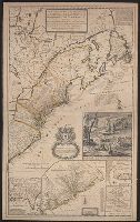
- Beinecke Rare Book and Manuscript Library > A new and exact map of the dominions of the King of Great Britain on ye continent of North America : containing Newfoundland, New Scotland, New England, New York, New Jersey, Pensilvania, Maryland, Virginia, and Carolina ... / by Herman Moll, geographer.
- Creator:
- Moll, Herman, d. 1732
- Published / Created:
- 1715 [i.e., 1726?]
- Call Number:
- 755 1715B
- Container / Volume:
- BRBL_00425
- Image Count:
- 1
- Resource Type:
- Maps, Atlases & Globes
- Found in:
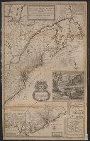
- Beinecke Rare Book and Manuscript Library > A new and exact map of the dominions of the King of Great Britain on ye continent of North America : containing Newfoundland, New Scotland, New England, New York, New Jersey, Pensilvania, Maryland, Virginia, and Carolina ... / by Herman Moll, geographer.
- Published / Created:
- 1826
- Call Number:
- 344cea 1826
- Container / Volume:
- BRBL_00095
- Image Count:
- 1
- Resource Type:
- Maps, Atlases & Globes
- Found in:
- Beinecke Rare Book and Manuscript Library > A new chart of the coast of Norway Christiansund to Stadtland ... Engraved by W.R. Pearcey.
- Published / Created:
- [1680?]
- Call Number:
- 7855 1680
- Container / Volume:
- BRBL_00691
- Image Count:
- 2
- Resource Type:
- Maps, Atlases & Globes
- Found in:
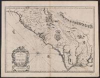
- Beinecke Rare Book and Manuscript Library > A new description of Carolina / Francis Lamb sculp.
- Published / Created:
- 1750
- Call Number:
- 3218 1750
- Container / Volume:
- BRBL_00057
- Image Count:
- 1
- Resource Type:
- Maps, Atlases & Globes
- Found in:
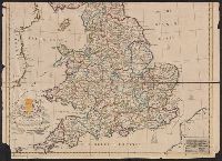
- Beinecke Rare Book and Manuscript Library > A new improved map of Oxfordshire ... By Thos. Kitchin Geographer.
- Published / Created:
- [1709?]
- Call Number:
- 34 1708
- Container / Volume:
- BRBL_00090
- Image Count:
- 1
- Resource Type:
- Maps, Atlases & Globes
- Found in:
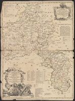
- Beinecke Rare Book and Manuscript Library > A new map of Denmark and Sweden ... H. Moll. Geographer.
- Creator:
- Senex, John, d. 1740
- Published / Created:
- 1714
- Call Number:
- 3191 1714
- Container / Volume:
- BRBL_00683
- Image Count:
- 2
- Resource Type:
- Maps, Atlases & Globes
- Found in:
- Beinecke Rare Book and Manuscript Library > A new map of Great Britain : corrected from the observations communicated to the Royal Society at London / by John Senex, F.R.S.
- Published / Created:
- 1714
- Call Number:
- 327 1714
- Container / Volume:
- BRBL_00072
- Image Count:
- 1
- Resource Type:
- Maps, Atlases & Globes
- Found in:
- Beinecke Rare Book and Manuscript Library > A new map of Ireland ... Herman Moll, Geographer 1714.
- Published / Created:
- 1714
- Call Number:
- 40 1714A
- Container / Volume:
- BRBL_00197
- Image Count:
- 1
- Resource Type:
- Maps, Atlases & Globes
- Found in:
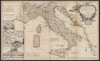
- Beinecke Rare Book and Manuscript Library > A new map of Italy ... post roads ... / H. Moll, geographer.