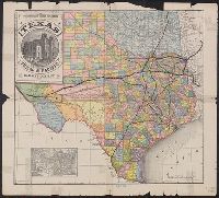
Proposed lines of the International R.R. of Mexico., Railroad map of Texas, Texas New Yorker., Texas New Yorker's map of the United States., and Travelers' and immigrants' guide, or railroad map to Texas
Description:
"Entered according to act of Congress in the year 1874 by Geo. H. Sweet in the office of the Librarian of Congress at Washington.", "Supplement to the 'Texas New Yorker' ....", From the Streeter collection., Includes text, ill., location map, and inset of "Proposed lines of the International R.R. of Mexico.", Prime meridians: Greenwich and Washington., Relief shown by hachures., and Text and "Texas New Yorker's map of the United States: showing the principal railroad routes" (scale [ca. 1:9,000,000]) on verso.
Publisher:
Geo. H. Sweet,
Subject (Name):
Streeter, Thomas W.--(Thomas Winthrop),--1883-1965--Ownership and Sweet, George H
Subject (Topic):
Railroads--Mexico--Maps, Railroads--Texas--Maps, and Railroads--United States--Maps
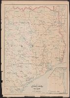
Red River, Sabine & Western Railway and Red River, Sabine and Western Railway
Description:
"I.[?] C. Terry, Chf. Eng.", Covers Texas and Louisiana, and parts of New Mexico, Indian Territory, Arkansas, Mississippi, and northern Mexico., From the Streeter collection., and Library's copy imperfect: Holes in center.
Publisher:
s.n.,
Subject (Name):
Red River, Sabine and Western Railway--Maps and Streeter, Thomas W.--(Thomas Winthrop),--1883-1965--Ownership
Subject (Topic):
Coal--Texas--Maps, Forests and forestry--Louisiana--Maps, Forests and forestry--Texas--Maps, Iron--Texas--Maps, Petroleum--Texas--Maps, Railroads--Louisiana--Maps, and Railroads--Texas--Maps
Includes ill. of "Court House, Paris, Texas" and inset of United States., Prime meridians: Greenwich and Washington., and Shows counties, boundary of lands granted to Texas & Pacific Railway, and railroad lines for the Texas & Pacific Railway Co., Fort Worth & Denver City Railway Co., Missouri Pacific Railway Co., Houston & Texas Railway Co., International & Great Northern Railroad, Galveston, Harrisburg & San Antonio Railway Co., Houston, East and West Texas Railway, New Orleans Pacific Railroad Co., and Texas & New Orleans Railroad.
Publisher:
Land Dept. of the Texas & Pacific Railway Co.,
Subject (Geographic):
Texas--Administrative and political divisions--Maps and Texas--Maps
Subject (Name):
Texas & Pacific Railway. Land Dept and Texas & Pacific Railway--Maps
Subject (Topic):
Railroad land grants--Texas--Maps and Railroads--Texas--Maps
"55" and "56" in right margin., "Entered according to act of Congress in the year 187[?] by Asher & Adams in the office of the Librarian of Congress at Washington.", From the Streeter collection., Includes map of "Portion of Texas.", Prime meridians: Greenwich and Washington., and Shows counties and railroads.
Publisher:
Asher & Adams,
Subject (Geographic):
Texas--Administrative and political divisions--Maps and Texas--Maps
Subject (Name):
Streeter, Thomas W.--(Thomas Winthrop),--1883-1965--Ownership
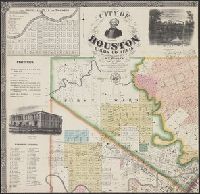
"Entered according to act of Congress in the year 1868 by W.E. Wood in the clerks office of the district court for the eastern district of Texas." and Includes text, indexes to properties on selected streets, and ill. of "Gen.l Sam Houston," "Buffalo Bayou draw-bridge," "Residence of E.S. Perkins," "Old capitol," "Christ Church," "Morris Building," "Perkin's Corner," "Pillot Building," "Allen Station," "Houston Gas Works," "Masonic Temple," "Eureka Mills," "Residence of A. Whitaker," "Residence of J.T.D. Wilson," "Miss Brown's Young Ladies Seminary," and "Houston City Stables."
Publisher:
W.E. Wood,
Subject (Geographic):
Houston (Tex.)--Maps
Subject (Name):
Blessing, J. P and Rease, W. H
Subject (Topic):
Election districts--Texas--Houston--Maps, Railroads--Texas--Maps, and Real property--Texas--Houston--Maps
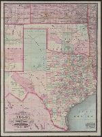
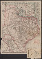
New county and railroad map of Texas and Indian Territory and New railroad and township map of Texas and Indian Territ'y
Description:
"Entered according to act of Congress in the year 1873 by G.F. Cram in the office of the librarian of Congress at Washington, D.C." and Relief shown by hachures.
Publisher:
George F. Cram,
Subject (Geographic):
Indian Territory--Maps, Texas--Administrative and political divisions--Maps, and Texas--Maps
Subject (Topic):
Railroads--Indian Territory--Maps and Railroads--Texas--Maps
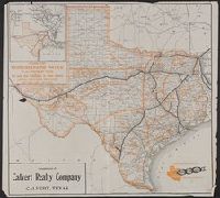
Iron mountain route, the way to Texas and Way to Texas
Description:
"Compliments of Calvert Realty Company, Calvert, Texas." and Advertising map published to promote the routes of the International & Great Northern, and Texas & Pacific railways and to encourage settlers to the state; reissued with differing advertising insets.
Publisher:
Poole Bros.,
Subject (Geographic):
Texas--Maps
Subject (Name):
Calvert Realty Company, International & Great Northern Railroad, International & Great Northern Railroad--Maps, Texas & Pacific Railway, and Texas & Pacific Railway--Maps
Subject (Topic):
Agricultural geography--Texas--Maps and Railroads--Texas--Maps
"Entered according to act of Congress on the 28th day of July 1848 by J. De Cordova in the clerk's office of the United States district court for the district of Texas.", "Without my signature all copies of this map have been fraudulently o, and Shows counties.
Publisher:
s.n.],
Subject (Geographic):
Texas--Administrative and political divisions--Maps and Texas--Maps
Subject (Name):
Atwood, John M., b. ca. 1818 and De Cordova, Jacob, 1808-1868
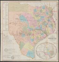
Rand, McNally & Co.'s Texas and Indian Territory and Texas and the Indian Territory
Description:
Includes map of western portion of Texas., Library's copy annotated in red ink and blue pencil., Library's copy attached to map showing, Prime meridians: Greenwich and Washington., Relief shown by hachures., and Shows county outlines, county seats, and railroads.
Publisher:
Rand, McNally & Co.,
Subject (Geographic):
Indian Territory--Maps, Texas--Administrative and political divisions--Maps, and Texas--Maps
Subject (Topic):
Railroads--Indian Territory--Maps, Railroads--Texas--Denison--Maps, and Railroads--Texas--Maps
Appears in City of Galveston, on Galveston Island, in Texas. 1837., Library's copy signed in ink on verso, "Gen. Robert Swartwout, New York, 1837.", Relief shown by hachures., and Shows beginnings of railroads near Trinity River and Houston.
Publisher:
s.n.,
Subject (Geographic):
Texas--Administrative and political divisions--Maps and Texas--Maps