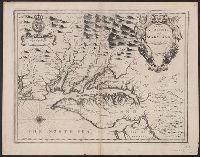
Author statement from McCorkle, p. 40., Includes ill. of animals and coat of arms., Relief shown pictorially., Verso: P. nos. "46", "45"; titles "The Description of New Neatherlands ... ", "The Description, and Verso: Stamped "Yale University Library".
Publisher:
Sold by Tho: Basset in Fleetstreet, and Richard Chiswell in St. Pauls Church Yard,
Subject (Geographic):
New England--Maps--Early works to 1800 and New York (State)--Maps--Early works to 1800
Subject (Name):
Bassett, Thomas, bookseller, Chiswell, Richard, Lamb, Francis, and Speed, John, 1552?-1629. Prospect of the most famous parts of the world
Appears in Speed's The theatre of the Empire of Great Britaine., English on recto, verso., Oriented west., Relief shown pictorially., Sheet measures 43.5 x 56 cm. Cross Collection no. 215., and Verso: Page nos. 43-44; titles "The description of Mary-land", "The description of Virginia"; signature Y.
Publisher:
Sold by Thomas Basset in Fleetstreet and Richard Chiswell in St. Pauls Church yard,
Subject (Geographic):
Maryland--History--Colonial period, ca. 1600-1775--Maps--Early works to 1800, Maryland--Maps--Early works to 1800, Virginia--History--Colonial period, ca. 1600-1775--Maps--Early works to 1800, and Virginia--Maps--Early works t
Subject (Name):
Bassett, Thomas, bookseller, Chiswell, Richard, Lamb, Francis, engraver, and Speed, John, 1552?-1629. Theatre of the Empire of Great Britaine
Appears in Speed's The theatre of the Empire of Great Britaine., English on recto, verso., Hand col. Sheet measures 41.7 x 54.4 cm., Oriented west., Relief shown pictorially., and Verso: Page nos. 43-44; titles "The description of Mary-land", "The descr
Publisher:
Sold by Thomas Basset in Fleetstreet and Richard Chiswell in St. Pauls Church yard,
Subject (Geographic):
Maryland--History--Colonial period, ca. 1600-1775--Maps--Early works to 1800, Maryland--Maps--Early works to 1800, Virginia--History--Colonial period, ca. 1600-1775--Maps--Early works t, and Virginia--Maps--Early works to 1800
Subject (Name):
Bassett, Thomas, bookseller, Chiswell, Richard, Lamb, Francis, engraver, and Speed, John, 1552?-1629. Theatre of the Empire of Great Britaine
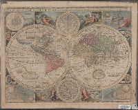
New and accurate map of the world and New and accvrat map of the world
Description:
Appeared in Speed's A prospect of the most famous parts of the world... London...1676., Imperfect: torn along fold, with some loss of text. Mounted on cardboard. Cross collection no. 18., Includes astrological charts, allegorical figures representing the elements, and portraits in medallions of explorers Sir Francis Drake, Ferdinand Magellan, Oliverus van der Noort and Thomas Candish., Relief shown pictorially., Scale measured at center of hemisphere., Shows California as an island., and This map is state 4, the last state published--Cf. Shirley R.W. Mapping of the world, 317.
Publisher:
Are to be sold by Tho. Bassett ... and Ric. Chiswell ...,
Subject (Name):
Bassett, Thomas, bookseller, bookseller, Chiswell, Richard, bookseller, and Speed, John, 1552?-1629. Prospect of the most famous parts of the world
Includes text, inset of Greenland, col. ill. of native figures and town views in margins., Matches item 2, dated 1626-7, in Tooley's California as an island (Map collector's circle, no. 8); Boston and Long Island not marked, [p.] 9-10 on verso., and Signature o
Publisher:
Are to be sold in Pops-head Alley against the exchange by G. Humble,
Subject (Geographic):
America--Maps--Early works to 1800 and Western Hemisphere--Maps--Early works to 1800
Subject (Name):
Goos, Abraham and Humble, George, d. 1640
Subject (Topic):
Cities and towns--America--Aerial views--Early works to 1800 and Indigenous peoples--America--Portraits--Early works to 1800
Hand col., Includes text, inset of Greenland, col. ill. o, Matches item 3, dated 1631, in Tooley's California as an island (Map collector's circle, no. 8); Boston and Long Island not marked, [p.] 10 on verso., Relief shown pictorially., and Signature on verso: E.
Publisher:
Are to be sold in Pops-head Alley against the exchange by G. Humble,
Subject (Geographic):
America--Maps--Early works to 1800 and Western Hemisphere--Maps--Early works to 1800
Humble, George, d. 1640 Speed, John, 1552?-1629 Sudbury, John
Published / Created:
1610
Call Number:
32 H421 1610
Container / Volume:
BRBL_00047A
Image Count:
2
Resource Type:
Maps, Atlases & Globes
Alternative Title:
Herefordshire described with the true plot of the citie Hereford as alsoe the armes of thos nobles that have bene intituled with that dignitye
Description:
"Cum privilegio"., Coats of arms., Depictions of Mercator and Ortelius., Inset map: Hereford., Pg. nos. on verso: 49-50., Pictorial view of the Battle of Mortimer's Cross (1461)., Signature on, Text on verso: Book I ... Chap. 25., and Title on verso: Hereford-shire.
Publisher:
To be solde in the Popes head alley against the Exchange by Iohn Sudbury and Georg Humbell ...,
Subject (Geographic):
Great Britain--History--Wars of the Roses, 1455-1485--Campaigns and Herefordshire (England)--Maps--Early works to 1800
Coordinates not present on item and are approximated., Insets: Plan of Salesbury -- Image of Stone Henge -- 14 coats of arms of the "Earles of Wilshyre & Salesburye." Images of "The armes of the Earles of Wilshyre & Salesburye ..." appear in the lower left of the map., On verso: English text with running-title "Book I. Wilt-Shire. Chap. 14", Signature "R", p. 25 and 26., Originally issued ca. 1610 and appeared in: Theatre of the Empire of Great Britaine. London, Sudbury & Humble, 1614 (i.e. 1616)., and Relief shown pictorially.
Publisher:
Performed by Iohn Speed and are to be sold in Popes head alley against the Exchange by Iohn Sudbury and G. Humble, cum privilegio,
Subject (Geographic):
Salisbury (England)--Maps--Early works to 1800, Stonehenge (England)--Maps--Early works to 1800, and Wiltshire (England)--Maps--Early works to 1800
Subject (Name):
Humble, George, -1640, Speed, John, 1552?-1629. Theatre of the Empire of Great Britaine, and Sudbury, John