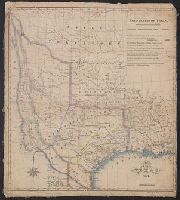
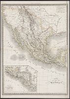
Proposed lines of the International R.R. of Mexico., Railroad map of Texas, Texas New Yorker., Texas New Yorker's map of the United States., and Travelers' and immigrants' guide, or railroad map to Texas
Description:
"Entered according to act of Congress in the year 1874 by Geo. H. Sweet in the office of the Librarian of Congress at Washington.", "Supplement to the 'Texas New Yorker' ....", From the Streeter collection., Includes text, ill., location map, and inset of "Proposed lines of the International R.R. of Mexico.", Prime meridians: Greenwich and Washington., Relief shown by hachures., and Text and "Texas New Yorker's map of the United States: showing the principal railroad routes" (scale [ca. 1:9,000,000]) on verso.
Publisher:
Geo. H. Sweet,
Subject (Name):
Streeter, Thomas W.--(Thomas Winthrop),--1883-1965--Ownership and Sweet, George H
Subject (Topic):
Railroads--Mexico--Maps, Railroads--Texas--Maps, and Railroads--United States--Maps
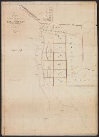
Red River, Sabine & Western Railway and Red River, Sabine and Western Railway
Description:
"I.[?] C. Terry, Chf. Eng.", Covers Texas and Louisiana, and parts of New Mexico, Indian Territory, Arkansas, Mississippi, and northern Mexico., From the Streeter collection., and Library's copy imperfect: Holes in center.
Publisher:
s.n.,
Subject (Name):
Red River, Sabine and Western Railway--Maps and Streeter, Thomas W.--(Thomas Winthrop),--1883-1965--Ownership
Subject (Topic):
Coal--Texas--Maps, Forests and forestry--Louisiana--Maps, Forests and forestry--Texas--Maps, Iron--Texas--Maps, Petroleum--Texas--Maps, Railroads--Louisiana--Maps, and Railroads--Texas--Maps
From the Streeter collection., Library's copy annotated in pencil on verso and stamped "T W Streeter.", Prime meridian: London., Relief shown pictorially., and Shows California as an island. Describes western and northwestern portions of North America as "Parts u
Publisher:
s.n.,
Subject (Geographic):
North America--Maps--Early works to 1800
Subject (Name):
Streeter, Thomas W.--(Thomas Winthrop),--1883-1965--Ownership
Staples, Stephen McL. (Stephen McLellan), 1800-1832
Published / Created:
1828
Call Number:
796ad 1828
Container / Volume:
BRBL_00716
Image Count:
2
Resource Type:
Maps, Atlases & Globes
Description:
From the Streeter collection., Includes text., Pen-and-ink and watercolor., Portion of map showing "Alamo Mocho," "Arroyo del Barrial," "R. Xaral," and "R. San Antonio" on verso., and Relief shown by hachures.
Subject (Geographic):
Coahuila and Texas (Mexico)--Maps, Manuscript and Texas--Maps
Subject (Name):
LeGrand, A. (Alexander) and Streeter, Thomas W.--(Thomas Winthrop),--1883-1965--Ownership
Subject (Topic):
Land grants--Texas--Maps, Manuscript and Manuscript maps
From Maillard's History of the Republic of Texas. London : Smith, Elder and Co., 1842., From the Streeter collection., Includes text., Library's copy annotated in pencil., Relief shown by hachures., and Shows "political, conventional and natural" boundaries of Texas, Indian tribes, Osage Territory, "Santa Fe, formerly New Mexico," and "Indian Territory attached to Arkansas."
Publisher:
Smith, Elder and Co.],
Subject (Geographic):
Mexico--Boundaries--Texas--Maps, Texas--Boundaries--Mexico--Maps, Texas--Boundaries--United States--Maps, Texas--Maps, and United States--Boundaries--Texas--Maps
Subject (Name):
Day & Haghe, Maillard, N. Doran (Nicholas Doran). History of the Republic of Texas, from the discovery of the country to the present time, and Streeter, Thomas W.--(Thomas Winthrop),--1883-1965--Ownership
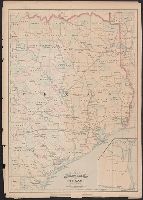
"55" and "56" in right margin., "Entered according to act of Congress in the year 187[?] by Asher & Adams in the office of the Librarian of Congress at Washington.", From the Streeter collection., Includes map of "Portion of Texas.", Prime meridians: Greenwich and Washington., and Shows counties and railroads.
Publisher:
Asher & Adams,
Subject (Geographic):
Texas--Administrative and political divisions--Maps and Texas--Maps
Subject (Name):
Streeter, Thomas W.--(Thomas Winthrop),--1883-1965--Ownership
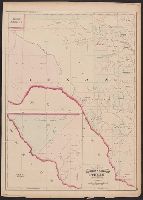
"57" and "58" in right margin., "Entered according to act of Congress in the year 187[?] by Asher & Adams in the office of the Librarian of Congress at Washington.", From the Streeter collection., Includes ancillary map of "Texas, western portion" showing El Paso and Presidio counties., Prime meridians: Greenwich and Washington., and Shows counties and "Texas Pacific R.R."
Publisher:
Asher & Adams,
Subject (Geographic):
Texas--Administrative and political divisions--Maps and Texas--Maps
Subject (Name):
Streeter, Thomas W.--(Thomas Winthrop),--1883-1965--Ownership
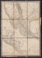
"La gravure dirigée et éxécutée par Lallemand.", From the Streeter collection., In upper left margin: Atlas universel., In upper right margin: 44e., Inset: Carte du Guatemala, ou provinces-unies de l'Améri, Prime meridian: Paris., and Relief shown by hachures.
Publisher:
s.n.,
Subject (Geographic):
Mexico--Maps and Southwest, New--Maps
Subject (Name):
Streeter, Thomas W.--(Thomas Winthrop),--1883-1965--Ownership
Cased with: Map of the Burman Empire. London : G.&J., Hand-colored boundaries., Insets: Guatemala ou Provinces-Unies de l'Amérique Centrale -- Iles Revillagigedo, and Library's copy 2 from the Streeter collection and dissected and mounted on linen, 50 x 35 cm.
Publisher:
A.H. Brué,
Subject (Geographic):
Central America--Maps and Mexico--Maps
Subject (Name):
Streeter, Thomas W.--(Thomas Winthrop),--1883-1965--Ownership
Subject (Topic):
Chron.--1825 and Engraving, Colored--Specimens--1825