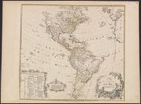
Includes text and ill., Library's copy annotated in ink in upper right corner, "12"; and on verso, annotated "Amérique 12" and stamped "Yale, Horace Brown, 1900S.", Relief shown pictorially., and Shows boundaries of lands claimed by the English, French, Spanish
Publisher:
s.n.,
Subject (Geographic):
America--Maps--Early works to 1800
Subject (Name):
Anville, Jean Baptiste Bourguignon d', 1697-1782, Bayly, J, Bellin, Jacques Nicolas, 1703-1772, and Bowles, Thomas, -1767
Map showing the communication of the lakes and the rivers between Lake Superior and Slave Lake in North America
Description:
"Gent. Mag. March 1790, Pl. I, p. 197" in upper right hand corner., Mounted on linen. Sheet measures 20.7 x 24.3 cm. Cross Collection no. 178., Prime meridian: London., and Relief shown by hachures.
Publisher:
s.n., 1790?]
Subject (Geographic):
Canada--Maps--Early works to 1800 and North America--Maps--Early works to 1800
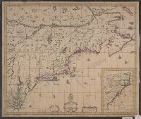
Accompanied by broadside text entitled: A description of New-England (4 p. ; 46 cm.)., Appears in author's Atlas maritimus, or, The sea-atlas, 1675., and Covers New England from the Penobscot River (Maine) region in the east to the Hudson River (New York) regio
Publisher:
And are to bee sold at his shop at the Hermitage in Wapping and by Iohn Hills in Exchange Alley in Cornhill,
Subject (Geographic):
New England--Maps--Early works to 1800
Subject (Name):
Hills, John, 17th cent and Seller, John, fl. 1658-1698. Atlas martitimus
Map of Virginia, Maryland, New Jersey, New-York & New England and Mapp of New England
Description:
"Separate publication ca. 1673 ... Various dates have been assigned to the map, from 1673 to 1685" (McCorkle 33)., Inset: "A mapp of New England"., Relief shown p, and Reproduced in McCorkle, p. 33. Verso: Ink ms. annotations; numbered "57" in ink ms.
Publisher:
By John Thornton ... and by Robert Greene ... ,
Subject (Geographic):
Middle Atlantic States--Maps--Early works to 1800, New England--Maps--Early works to 1800, and New York (State)--Maps--Early works to 1800
Map of all the world in two hemispheres in which are exactly described all the parts of the earth and seas
Description:
Dedicated To the most serene and most sacred majesty of Charles II ..., Described by Sanson ; corrected and amended by William Berry., Includes coat of arms and decorative cartouche containing dedication., No. 1 of 69 maps bound together in composite atlas., Prime meridian: Ferro., Relief shown pictorially., Scale [ca. 1:60 000 000]., and Shows California as an island.
Publisher:
Sold by William Berry at ye sign of the globe between Charing-Cross and White-Hall
Subject (Geographic):
Eastern Hemisphere --Maps --Early works to 1800 and Western Hemisphere --Maps --Early works to 1800
Darly, Matthias, approximately 1720-approximately 1778, printmaker
Published / Created:
[10 April 1777]
Call Number:
777.04.10.01+
Image Count:
1
Resource Type:
still image
Abstract:
Seven members of the City Militia march out of step towards the right, 2 birds flying overhead. A short fat drummer begins the procession, followed by an officer with sword in left hand, 2 pairs of soldiers carrying bayoneted muskets, and in the rear, a hunchback carrying a spear
Description:
Title from item., Soiled at top and trimmed into image with partial loss of artist's name., Artist from British Museum catalogue., Signed (by engraver?) in plate MD (i.e. Matthias Darly), and MD of publisher's name form a monogram.
Publisher:
Pubd. April 10, 1777 by MDarly ...
Subject (Geographic):
England., England, and London.
Subject (Name):
Great Britain
Subject (Topic):
Militia, Militias, Military uniforms, British, Drums, and Musketeers