
You Searched For
« Previous
| 1 - 10 of 15 |
Next »
Search Results
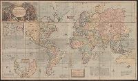
2.
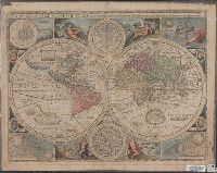
- Creator:
- Speed, John, 1552?-1629
- Published / Created:
- 1651 [1676 printing]
- Call Number:
- 11 1651
- Container / Volume:
- BRBL_00680
- Image Count:
- 1
- Resource Type:
- Maps, Atlases & Globes
- Alternative Title:
- New and accurate map of the world and New and accvrat map of the world
- Description:
- Appeared in Speed's A prospect of the most famous parts of the world... London...1676., Imperfect: torn along fold, with some loss of text. Mounted on cardboard. Cross collection no. 18., Includes astrological charts, allegorical figures representing the elements, and portraits in medallions of explorers Sir Francis Drake, Ferdinand Magellan, Oliverus van der Noort and Thomas Candish., Relief shown pictorially., Scale measured at center of hemisphere., Shows California as an island., and This map is state 4, the last state published--Cf. Shirley R.W. Mapping of the world, 317.
- Publisher:
- Are to be sold by Tho. Bassett ... and Ric. Chiswell ...,
- Subject (Name):
- Bassett, Thomas, bookseller, bookseller, Chiswell, Richard, bookseller, and Speed, John, 1552?-1629. Prospect of the most famous parts of the world
- Subject (Topic):
- World maps--Early works to 1800
- Found in:
- Beinecke Rare Book and Manuscript Library > A new and accurat map of the world : drawne according to ye truest descriptions, latest discoueries & best obseruations y[e]t have beene made by english or strangers.
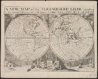
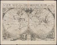
3.
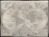
- Creator:
- Walton, Robert, 1618-1688
- Call Number:
- Lanman 11 1659A
- Image Count:
- 1
- Resource Type:
- Maps, Atlases & Globes
- Alternative Title:
- New and accurat map of the world and New and accurate map of the world
- Description:
- Attributed to Robert Walton; based on a map by John Speed., From Denis Petau's History of the world (1659)., Includes insets of "The heavens and elements," "The eclipse of the sunn," "A figure of the spheare," and "The eclipse of the moone," 2 celestial hemispheres, historical notes, and illustrations., Relief shown pictorially., Shows California as an island., and Watermark.
- Subject (Name):
- Petau, Denis, 1583-1652 and Speed, John, 1552?-1629
- Subject (Topic):
- World maps--Early works to 1800
- Found in:
- Beinecke Rare Book and Manuscript Library > A new and accvrat map of the world : drawne according to ye truest descriptions latest discoveries & best observations y[e]t have beene made by English or strangers.
- Published / Created:
- 1719
- Call Number:
- 11 1719A
- Container / Volume:
- BRBL_00004
- Image Count:
- 1
- Resource Type:
- Maps, Atlases & Globes
- Description:
- Insets: Chart of magnetic variations; North Pole.
- Publisher:
- Sold by H. Moll ... ,
- Subject (Geographic):
- World--Maps--Early works to 1800
- Subject (Topic):
- World maps--Early works to 1800
- Found in:
- Beinecke Rare Book and Manuscript Library > A new and correct map of the whole world ... / by Herman Moll ...
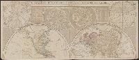
- Published / Created:
- 1719
- Call Number:
- 11 1719B
- Container / Volume:
- BRBL_00004
- Image Count:
- 1
- Resource Type:
- Maps, Atlases & Globes
- Description:
- Insets: Chart of magnetic variations; North Pole.
- Publisher:
- Sold by H. Moll ... I. King ... Printed for John Bowles ... Tho. Bowles ... ,
- Subject (Geographic):
- World--Maps--Early works to 1800
- Subject (Topic):
- World maps--Early works to 1800
- Found in:
- Beinecke Rare Book and Manuscript Library > A new and correct map of the whole world ... / by Herman Moll ...
6.

- Creator:
- Moll, Herman, d. 1732
- Published / Created:
- [after 1754]
- Call Number:
- 11 1728
- Container / Volume:
- BRBL_00680
- Image Count:
- 1
- Resource Type:
- Maps, Atlases & Globes
- Description:
- Cross collection no. 34., Double hemispherical map of the world showing countries, Dampier's voyage, winds, planetary systems, charts and appearance of the sun and moon. Relief shown pictorially., Imperfect: third name in imprint illegible. Hand col. Mounted on linen., Scale measured at center of hemisphere., and Shows California as an island.
- Publisher:
- Printed for I. Bowles ... Ca. Bowles ... and sold by [?] ... R. Sayer ... and Iohn King ...,
- Subject (Name):
- Bowles, Carington, 1724-1793, bookseller, Bowles, John, 1701-1779, bookseller, and Sayer, Robert, 1725-1794, bookseller
- Subject (Topic):
- World maps--Early works to 1800
- Found in:
- Beinecke Rare Book and Manuscript Library > A new and correct map of the world laid down according to the newest discoveries and from the most exact observations / [cartographic material] / by Herman Moll, geographer.
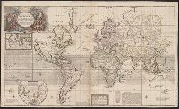
7.

- Creator:
- Moll, Herman, -1732
- Published / Created:
- [1729?]
- Call Number:
- 11 1724
- Container / Volume:
- BRBL_00680
- Image Count:
- 1
- Resource Type:
- Maps, Atlases & Globes
- Description:
- Imperfect: mutilated and torn along folds, with some loss of text. Cross collection no. 33., Includes dedication within ornamental cartouche, "To His Most Sacred Majesty George IId by the grace of God King of Great Britain France & Ireland Defender of the Faith &c. this map is humbly dedicated.", Includes text., Insets: The Ptolemean systeme -- The North Pole -- The Copernican systeme -- Mercury -- The appearance of the Sun -- Venus -- Mars -- Saturn -- Jupiter -- The appearance of the Moon., Prime meridian: Ferro., Relief shown pictorially., Scale measured at center of hemisphere., Shows California as an island., and Shows the world as a double hemisphere, annual winds and wind directions, solar equinox and ecliptic, and noted corrections over previous geography.
- Publisher:
- Printed for and sold by I. Bowles, map and printseller at the Black Horse in Cornhill & by T. Bowles map & print seller next to ye Chapter house in St. Paul's Church yard, and by P. Overton map & print seller near St. Dunstan's Church Fleet Street and by
- Subject (Name):
- Bowles, John, 1701-1779, bookseller, Bowles, Thomas, -1767, bookseller, and Overton, Philip, -1751, bookseller
- Subject (Topic):
- World maps--Early works to 1800
- Found in:
- Beinecke Rare Book and Manuscript Library > A new and correct map of the world laid down according to the newest discoveries, and from the most exact observations / [cartographic material] / by Herman Moll, geographer.

- Published / Created:
- 1737
- Call Number:
- 11 1737
- Container / Volume:
- BRBL_00681
- Image Count:
- 1
- Resource Type:
- Maps, Atlases & Globes
- Alternative Title:
- New and correct map of the world
- Description:
- Contains two hemispheres, with text on Newton's theory of tides and 2 smaller hemispheres of constellations at top, and ill. of the moon and other planets at middle and bottom., Imperfect: mutilated along folds, with some loss of text. Cross collection no. 35., and Relief is shown pictorially.
- Publisher:
- Printed for and sold by Geo. Foster ....,
- Subject (Name):
- Foster, George, fl. 1737-1739, bookseller
- Subject (Topic):
- World maps--Early works to 1800
- Found in:
- Beinecke Rare Book and Manuscript Library > A new and correct map of ye world [cartographic material] : laid down according to ye latest and best observations : to which is added several curious discourses on the tides, trade winds & monsoons ...
- Creator:
- Wells, Edward, 1667-1727
- Published / Created:
- 1726 or 1738]
- Call Number:
- 11 1701
- Container / Volume:
- BRBL_00680
- Image Count:
- 1
- Resource Type:
- Maps, Atlases & Globes
- Description:
- "Dedicated to His Highness William Duke of Gloucester.", "Delin. M. Burghers sculpt. Univ. Oxon.", Cross collection no. 32., Plate mark 1 was added below the dedication plinth for the editions in 1726 and 1738--Cf. Shirley., and Scale measured at center of hemisphere.
- Publisher:
- s.n.,
- Subject (Name):
- Burghers, M and Wells, Edward, 1667-1727. New sett of maps both of antient and present geography
- Subject (Topic):
- World maps--Early works to 1800
- Found in:
- Beinecke Rare Book and Manuscript Library > A new map of the terraqueous globe : according to the ancient discoveries and most general divisions of it into continents and oceans.
10.
- Creator:
- Wells, Edward, 1667-1727
- Published / Created:
- 1726 or 1738]
- Call Number:
- 11 1701A
- Container / Volume:
- BRBL_00680
- Image Count:
- 1
- Resource Type:
- Maps, Atlases & Globes
- Description:
- "Dedicated to His Highness William Duke of Gloucester.", "Delin. M. Burghers sculpt. Univ. Oxon.", Appeared in Wells' New sett of maps both of antient and present geography., Cross collection no. 31., Double hemisphere on sheet in outline, with rivers, capes and island marked but few other place names., Plate mark 2 was added below the dedication plinth for the editions in 1726 and 1738--Cf. Shirley., Scale measured at center of hemisphere., and Slip pasted to verso of map: Property of Andrew Arthur Benton, New York, N.Y.
- Publisher:
- s.n.,
- Subject (Name):
- Benton, Andrew Arthur--Ownership, Burghers, M, and Wells, Edward, 1667-1727. New sett of maps both of antient and present geography
- Subject (Topic):
- World maps--Early works to 1800
- Found in:
- Beinecke Rare Book and Manuscript Library > A new map of the terraqueous globe : according to the latest discoveries and most general divisions of it into continents and oceans.