Backed with paper. Ms. no. "78" in upper right-hand corner. Sheet measures 53.6 x 62.8 cm. No. 72 of 87 maps bound together., Includes four bar scales., and Relief shown pictorially.
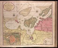
Haven en Stad Wismar and Stad Wismar met alles desselfs Sterktens.
Description:
"Aen de niuwe brugh met previlegie"., Appeared in Gerard van Keulen's Nieuwe groote ligtende Zee-Fakkel ... 1734; cf. Koeman, C. Atlantes Neerlandici, IV, Keu 45, map 22., Backed with paper. Ms. no. "9" [partially trimmed] in upper right-hand corner. Sheet measures 53.5 x 62.5 cm. No. 8 of 87 maps bound together., Bar scale given in "Duytsche Myl"., Includes inset map "De stad Wismar met alles desselfs Sterktens"., Relief shown pictorially; depths shown by soundings., and Watermark.
Publisher:
By Gerard van Keulen,
Subject (Geographic):
Wismar (Germany)--Maps--Early works to 1800.
Subject (Name):
Keulen, Gerard van. Nieuwe groote lichtende zee-fakkel.
Subject (Topic):
Nautical charts--Germany--Wismar Bay--Early works to 1800.
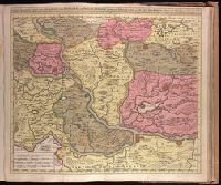
Backed with paper. Ms. no. "79" in upper right-hand corner. Sheet measures 53.6 x 62.5 cm. No. 73 of 87 maps bound together., Bar scale given in "Schaale van 200 Klaffter Turckse Maet.", Relief shown pictorially., and With inset bird's-eye view of Belgrade in upper left corner.
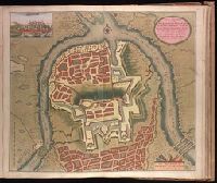
"Met previlegie.", Appeared in Gerard van Keulen's Nieuwe groote ligtende Zee-Fakkel ... 1734; cf. Koeman, C. Atlantes Neerlandici, IV, Keu 45, map 26., Backed with paper. Ms. no. "13" in upper right-hand corner. Sheet measures 53.6 x 62.8 cm. No. 12 of 87 maps bound together., Bar scale given in "Duytsche Mylen"., Includes inset map: De stad Straalsund / L. v. Ansée s., Relief shown pictorially; depths shown by soundings., and Watermark.
Publisher:
By Gerard van Keulen ...,
Subject (Geographic):
Rügen Island (Germany)--Maps--Early works to 1800. and Stralsund (Germany)--Maps--Early works to 1800.
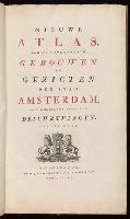
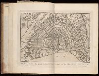
Descriptive letterpress in Dutch and French at foot of most of the plates., Engraved title vignette (coat of arms of Amsterdam)., First edition (in book form) was published about 1770 under title: Afbeeldingen van de wijd vermaarde koopstad Amsterdam, benevens deszelfs voornaamste gebouwen en gezigten (Amsterdam, P. Fouquet jr.)--cf. Muller, Frederik, & co. Oud-Amsterdam [1912], p. 14., and Paged continuously (by signatures).
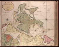
Backed with paper. Ms. no. "66" in upper right-hand corner. Sheet measures 53.7 x 62.3 cm. No. 61 of 87 maps bound together., Includes four bar scales., Relief shown pictorially; depths shown by soundings., and With north oriented to the left.
Publisher:
By Gerard van Keulen, aen de nieuwe Brug met privilegie,
Subject (Geographic):
Sardinia (Italy)--Maps--Early works to 1800.
Subject (Topic):
Nautical charts--Mediterranean Sea--Early works to 1800.
Keulen, Gerard van Keulen, Johannes van, fl. 1726-1753. Nieuwe groote lichtende zee-fakkel
Call Number:
303cea 1680
Container / Volume:
BRBL_00033
Image Count:
1
Resource Type:
Maps, Atlases & Globes
Alternative Title:
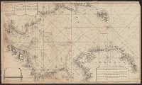
New sea map of the whole North Sea and Nouvelle carte marine generale de la Mer du Nord
Description:
Appeared in Joannes van Keulen's De Nieuwe groote, Backed with paper. Sheets measure 61.0 x 52.2 cm or smaller., Includes five bar scales., Relief shown pictorially; depth shown by soundings., and Scale estimated by measurement of degree of latitude.