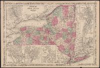
In right margin: 54, 55., On verso: Historical and statistical view of the United States, 1860; 67, 66., Prime meridians: Greenwich, Washington., and Shows railroads and counties.
Publisher:
A.J. Johnson,
Subject (Geographic):
Illinois--Maps
Subject (Topic):
Counties--Illinois--Maps and Railroads--Illinois--Maps
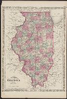
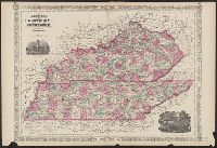
"Entered according to Act of Congress in the Year 1865 by A.J. Johnson in the Clerks Office of the District Court of the United States for the Southern District of New York.", In upper left margin: 48., In upper right margin: 49., and Includes illustrations titled "State House Nashville" and "Entrance to Mammoth Cave."
Publisher:
A.J. Johnson,
Subject (Geographic):
Kentucky--Maps and Tennessee--Maps
Subject (Topic):
Cities and towns--Kentucky--Maps, Cities and towns--Tennessee--Maps, Counties--Kentucky--Maps, Counties--Tennessee--Maps, Railroads--Kentucky--Maps, Railroads--Tennessee--Maps, and Roads--Kentu
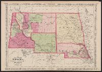
Date inferred from Nebraska counties--shows "Lyon," "Taylor," "Monroe," "Harrison," "Jackson," and "Grant" in southwest Nebraska (listed in 1870 Federal Census?) and Wayne County (formed 1871). Also shows Wyoming w and In upper left and right corners: 67, 68.
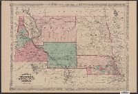
"Historical and statistical view of the United States 1860" (75, 76) on verso., Date inferred from Union Pacific-Central Pacific railroad shown incomplete; Laramie does not appear; an, and Library's copy annotated in pencil on verso: A.J. Johnson-New York-1867.
Map numbered 62 & 63., Mounted on linen. Text of verso obscured., On verso: "Text on historical and statistical view of the United States, 1860.", and Removed from Johnson's new illustrated family atlas of the world ... with a treatise on physical geography. New York, Johnson and Ward, 1865.?
Publisher:
A.J. Johnson,
Subject (Geographic):
Dakota Territory--Maps, Idaho--Maps, Montana--Maps, and Nebraska--Maps