Uytenbogaart, J. W. H. (Johannes Wilhelmus Huybert) Wit, Frederik de., creator
Published / Created:
[1680?]
Call Number:
1973 Folio 10
Image Count:
1
Resource Type:
Maps, Atlases & Globes
Description:
Appears in the Wit's Atlas from 1680., Dedication: Amplissimo Doctissimoque Viro Domino Do. Joanni Uytenbogaert Jcto. nomine Illustrium et praepotent. DD. ordinum Hollandiae et Westvrisiae Aerary Publici Amstelodamensis Tribuno., Includes color illustrated views of Messina, Catania, and Trapano, and ancillary maps of Milazzo and Palermo., No. 21 of 69 maps bound together in composite atlas., Oriented with north toward the upper left., Relief shown pictorially., Scale indeterminable., and Urbibus praecipuis exornatum et novissime editum per F. de Wit.
Publisher:
Gedruckt tot Amsterdam by Frederik de Wit inde Kalverstraet by den Dam inde Witte Paskaert
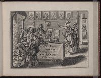
Bound, as issued, with the author's Tractaet vant zee-bouck-houden. [Amsterdam] 1597., Engraved t.-p., and Signatures: A⁴ (A2-3 signed A1-2) A-C⁸ A-E⁸.
Publisher:
Ghedruckt by Barendt Adriaenzoon in t' Vergulde Schryf-boeck ...,
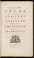
Descriptive letterpress in Dutch and French at foot of most of the plates., Engraved title vignette (coat of arms of Amsterdam)., First edition (in book form) was published about 1770 under title: Afbeeldingen van de wijd vermaarde koopstad Amsterdam, benevens deszelfs voornaamste gebouwen en gezigten (Amsterdam, P. Fouquet jr.)--cf. Muller, Frederik, & co. Oud-Amsterdam [1912], p. 14., and Paged continuously (by signatures).
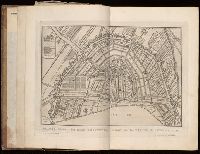
Ferro meridian., Gemeene Duytsche mylen van 15 in een graedt., No. 53 of 69 maps bound together in composite atlas., Relief shown pictorially., and Scale [ca 1:8 750 000].
Publisher:
By Frederick de Wit in de Kalversbraet in de Witte Pascaert
Descriptio ac delineatio geographica detectionis freti, sive, transitus ad occasum supra terras
Image Count:
1
Abstract:
Map depicts the Coat of Arms of the United Kingdom (era of the Union of the Crowns), reigning between the years 1603-1707.
Alternative Title:
Tabula nautica, qua repraesentantur orae maritimae, meatus, ac freta, noviter a H. Hudsono Anglo ad Caurum supra Novam Franciam
Description:
Bound in after p. [2]., In pencil on recto: 170., Map cut and folded irregularly., Map has multiple small stains on both the recto and verso., and Scale [ca. 1:9,000,000].
Charts and title pages in English, text in Dutch., Map oriented with North at bottom left., and Volvelle on p. [17].
Publisher:
Jodocus Hondius excudit,
Subject (Geographic):
Europe --Maps --Early works to 1800, Great Britain --Maps --Early works to 1800, Netherlands --Maps --Early works to 1800, and North Sea --Maps --Early works to 1800