Search
You Searched For
Search Results
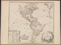
- Creator:
- Delarochette, L. (Louis), 1731-1802
- Published / Created:
- 17--?]
- Call Number:
- 70 1770
- Container / Volume:
- BRBL_00356
- Image Count:
- 1
- Resource Type:
- Maps, Atlases & Globes
- Found in:
- Beinecke Rare Book and Manuscript Library > A map of the whole continent of America : according to D'Anville & Bellin / by L. Delarochette ; Bayly, sculpt.
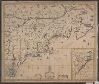
- Published / Created:
- [1684?]
- Call Number:
- 755 1684A
- Container / Volume:
- BRBL_00424
- Image Count:
- 1
- Resource Type:
- Maps, Atlases & Globes
- Found in:
- Beinecke Rare Book and Manuscript Library > A map of ye English Empire in Y Continent of America, ... W. Binneman, sculpsit.
- Call Number:
- 735 1790
- Container / Volume:
- BRBL_00689
- Image Count:
- 1
- Resource Type:
- Maps, Atlases & Globes
- Found in:
- Beinecke Rare Book and Manuscript Library > A map shewing the communication of the lakes and the rivers between Lake Superior and Slave Lake in North America.
- Published / Created:
- 1803
- Call Number:
- 771 1803
- Container / Volume:
- BRBL_00477
- Image Count:
- 1
- Resource Type:
- Maps, Atlases & Globes
- Found in:
- Beinecke Rare Book and Manuscript Library > A map showing the relative situation of a trct of land belonging to I.B. Church Esqr. situated on the Genesee River in Western New York State.
- Creator:
- Seller, John, fl. 1658-1698
- Published / Created:
- [1675]
- Call Number:
- 76 1675
- Image Count:
- 1
- Resource Type:
- Maps, Atlases & Globes
- Found in:
- Beinecke Rare Book and Manuscript Library > A mapp of New England / by John Seller, hydrographer to the King.
- Creator:
- Thornton, John, fl. 1652-1701
- Published / Created:
- [1673?]
- Call Number:
- 755 1682B
- Container / Volume:
- BRBL_00424
- Image Count:
- 1
- Resource Type:
- Maps, Atlases & Globes
- Found in:
- Beinecke Rare Book and Manuscript Library > A mapp of Virginia, Mary-land, New-Jarsey, New-York, & New England.
- Creator:
- Berry, William, fl. 1669-1708, creator
Sanson, Nicolas, 1600-1667
- Published / Created:
- 1680
- Call Number:
- 1973 Folio 10
- Image Count:
- 1
- Resource Type:
- Maps, Atlases & Globes
- Found in:
- Beinecke Rare Book and Manuscript Library > A mapp of all the world in two hemispheres in which are exactly described all the parts of the earth and seas
- Published / Created:
- [17--?]
- Call Number:
- 39 C11 1702
- Container / Volume:
- BRBL_00189
- Image Count:
- 1
- Resource Type:
- Maps, Atlases & Globes
- Found in:
- Beinecke Rare Book and Manuscript Library > A mapp of the bay and towne of Cadiz : with all it's fortifications as it was ye 15th. of August 1702, at the time of Sr. George Rooke's coming before it / H. Hulsbergh, scu.
- Published / Created:
- 1734
- Call Number:
- 771 N49 1734
- Container / Volume:
- BRBL_00713
- Image Count:
- 1
- Resource Type:
- Maps, Atlases & Globes
- Found in:
- Beinecke Rare Book and Manuscript Library > A mapp or survey of the swamp or Crupel-bush in Montgomerie Ward in the city of New York ... 1734. Copied ... 1823, 1830 ... 1899 by W.F. Osborne.
- Creator:
- Darly, Matthias, approximately 1720-approximately 1778, printmaker
- Published / Created:
- [10 April 1777]
- Call Number:
- 777.04.10.01+
- Image Count:
- 1
- Resource Type:
- still image
- Found in:
- Lewis Walpole Library > A march of the train bands [graphic]