Search
You Searched For
Search Results
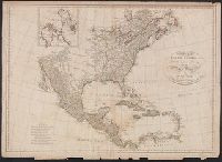
- Creator:
- Harrison, John, fl. 1784-1792
- Published / Created:
- 1791?]
- Call Number:
- 71 1791
- Container / Volume:
- BRBL_00367
- Image Count:
- 1
- Resource Type:
- Maps, Atlases & Globes
- Found in:
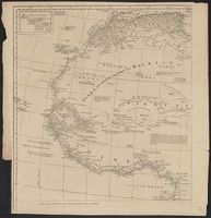
- Beinecke Rare Book and Manuscript Library > A map of North America : published under the patronage of the Duke of Orleans by d'Anville / drawn and engraved for J. Harrison, No. 115 Newgate Street, January 1, 1791.
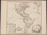
- Creator:
- Seale, Richard William
- Published / Created:
- 1745?]
- Call Number:
- 71 1746
- Container / Volume:
- BRBL_00362
- Image Count:
- 1
- Resource Type:
- Maps, Atlases & Globes
- Found in:
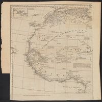
- Beinecke Rare Book and Manuscript Library > A map of North America : with the European settlements & whatever else is remarkable in ye West Indies, from the latest and best observations / R.W. Seale, delin. et sculp.
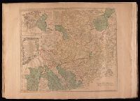
- Creator:
- Jefferys, Thomas, d. 1771
- Published / Created:
- 175-?]
- Call Number:
- 1977 Folio 177
- Image Count:
- 2
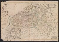
- Resource Type:
- Maps, Atlases & Globes
- Found in:
- Beinecke Rare Book and Manuscript Library > A map of the circle of Westphalia comprehending the bishopricks of Liege, Munster, Paderborn & Osnabrug, the dutchies of Westphalia, Cleves, Juliers, Berg & Verden with the principalities of Minden & East Friesland and the counties of Mark, Ravensberg, Ol
- Creator:
- Delarochette, L. (Louis), 1731-1802
- Published / Created:
- 17--?]
- Call Number:
- 70 1770
- Container / Volume:
- BRBL_00356
- Image Count:
- 1
- Resource Type:
- Maps, Atlases & Globes
- Found in:
- Beinecke Rare Book and Manuscript Library > A map of the whole continent of America : according to D'Anville & Bellin / by L. Delarochette ; Bayly, sculpt.
- Call Number:
- 735 1790
- Container / Volume:
- BRBL_00689
- Image Count:
- 1
- Resource Type:
- Maps, Atlases & Globes
- Found in:
- Beinecke Rare Book and Manuscript Library > A map shewing the communication of the lakes and the rivers between Lake Superior and Slave Lake in North America.
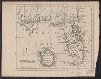
- Published / Created:
- 176-?]
- Call Number:
- 792 1750
- Container / Volume:
- BRBL_00691
- Image Count:
- 1
- Resource Type:
- Maps, Atlases & Globes
- Found in:
- Beinecke Rare Book and Manuscript Library > A new and accurate map of east and west Florida [cartographic material] : drawn from the best authorities / J. Prockter sculp.
- Creator:
- Senex, John, d. 1740
- Published / Created:
- 1714
- Call Number:
- 33 1714
- Container / Volume:
- BRBL_00683
- Image Count:
- 1
- Resource Type:
- Maps, Atlases & Globes
- Found in:
- Beinecke Rare Book and Manuscript Library > A new and correct map of the ten Spanish provinces : according to the new observations communicated to the Royal Society at London and the Royal Academy at Paris ? / by Iohn Senex.
- Published / Created:
- 1750?]
- Call Number:
- 40 R66 1750
- Container / Volume:
- BRBL_00216
- Image Count:
- 1
- Resource Type:
- Maps, Atlases & Globes
- Found in:
- Beinecke Rare Book and Manuscript Library > A plan of Rome, survey'd and publish'd by Mr. G.B. Nolli / R. Benning, sc.
- Creator:
- Anville, Jean Baptiste Bourguignon d', 1697-1782
- Published / Created:
- 1766?]
- Call Number:
- 60 1766
- Container / Volume:
- BRBL_00323
- Image Count:
- 4
- Resource Type:
- Maps, Atlases & Globes
- Found in:
- Beinecke Rare Book and Manuscript Library > Africa / performed by the Sr. Danville under the patronage of the Duke of Orleans ; revised and improved by Mr. Bolton ; E. Bowen sculpt.
- Creator:
- Anville, Jean Baptiste Bourguignon d', 1697-1782
- Published / Created:
- 1774?]
- Call Number:
- 60 1774
- Container / Volume:
- BRBL_00323
- Image Count:
- 4
- Resource Type:
- Maps, Atlases & Globes
- Found in:
- Beinecke Rare Book and Manuscript Library > Africa / performed by the Sr. Danville under the patronage of the Duke of Orleans ; revised and improved by Mr. Bolton ; E. Bowen sculpt.
- Published / Created:
- 1663
- Call Number:
- 70 1663
- Container / Volume:
- BRBL_00354
- Image Count:
- 1
- Resource Type:
- Maps, Atlases & Globes
- Found in:
- Beinecke Rare Book and Manuscript Library > Americae nova descriptio / imperisis An[n]ae Seile ; Rob. Vaughan sculp.
- Creator:
- Bowen, Emanuel, d. 1767
- Published / Created:
- 1748
- Call Number:
- 49 1748
- Container / Volume:
- BRBL_00267
- Image Count:
- 1
- Resource Type:
- Maps, Atlases & Globes
- Found in:
- Beinecke Rare Book and Manuscript Library > An accurate chart of the Mediterranean and Adriatic Seas, with the archipelago & part of the Black Sea : exhibiting all the islands in those seas, as also, the adjacent countries on the continents of Europe, Africa & Asia / drawn from the most approved ma
- Published / Created:
- ca. 1760]
- Call Number:
- 7345 Q31 1759
- Container / Volume:
- BRBL_00380
- Image Count:
- 1
- Resource Type:
- Maps, Atlases & Globes
- Found in:
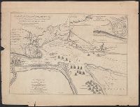
- Beinecke Rare Book and Manuscript Library > An authentic plan of the River St. Laurence from Sillery, to the fall of Montmorenci : with the operations of the siege of Quebec under the command of Vice-Adml. Saunders & Major Genl. Wolfe down to the 5. Sepr. 1759 / drawn by a captain in His Majesties
- Published / Created:
- 1547
- Call Number:
- Me45 M333 D4
- Image Count:
- 16
- Found in:
- Beinecke Rare Book and Manuscript Library > An heauenly acte concernyng howe man shall lyue : made by our soueraigne Lord God the Father, God the so[n]ne, and God the holy gost, and at the whole Clergye in heauen consentyng to the same.
- Published / Created:
- 1969?]-
- Call Number:
- 2009 +S118
- Image Count:
- 1
- Found in:
- Beinecke Rare Book and Manuscript Library > Arson news.
- Published / Created:
- 1905]
- Call Number:
- 36 B45 1905
- Container / Volume:
- BRBL_00122
- Image Count:
- 1
- Resource Type:
- Maps, Atlases & Globes
- Found in:
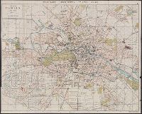
- Beinecke Rare Book and Manuscript Library > Bradshaw's continental railway guide. 2. Plan of Berlin.
- Published / Created:
- 1845]
- Call Number:
- 88 1845D
- Container / Volume:
- BRBL_00645
- Image Count:
- 1
- Resource Type:
- Maps, Atlases & Globes
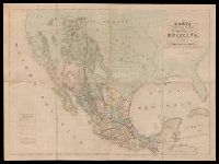
- Found in:
- Beinecke Rare Book and Manuscript Library > Carta geografica general de la republica Mexicana / formada el ano de 1845, con los datos que reunio la seccion de Geografia del Ministerio de la Guerra, por el General de Brigada Pedro Garcia Conde.
- Published / Created:
- 1754?]
- Call Number:
- 71 1754
- Container / Volume:
- BRBL_00362
- Image Count:
- 1
- Resource Type:
- Maps, Atlases & Globes
- Found in:
- Beinecke Rare Book and Manuscript Library > Carte de l'Amérique septentrionale, 1754.
- Published / Created:
- 179-?]
- Call Number:
- 71 1784
- Container / Volume:
- BRBL_00687
- Image Count:
- 1
- Resource Type:
- Maps, Atlases & Globes
- Found in:
- Beinecke Rare Book and Manuscript Library > Chart of the N.W. coast of America and N.E. coast of Asia : explored by Capt. Cook and Capt. Clerke, in the years 1778 and 1779.
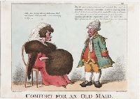
- Creator:
- Woodward, G. M. (George Moutard), approximately 1760-1809, artist
- Published / Created:
- 1810?]
- Call Number:
- 810.00.00.70+
- Image Count:
- 1
- Found in:
- Lewis Walpole Library > Comfort for an old maid [graphic] / Woodward del. ; etch'd by Roberts.