
You Searched For
« Previous
| 11 - 18 of 18 |
Next »
Search Results

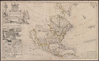
- Creator:
- Moll, Herman, d. 1732
- Published / Created:
- [1720]
- Call Number:
- 71 1720D
- Container / Volume:
- BRBL_00361
- Image Count:
- 1
- Resource Type:
- Maps, Atlases & Globes
- Alternative Title:
- North America, according to ye newest and most exact observations
- Description:
- Appears in the author's The world described, or a new and correct sett of maps., Has watermark., Includes text, 10 insets of North American ports, decorative cartouche with coat of arms and figures, and "view of a stage & also, and Shows California as an island.
- Publisher:
- Printed for H. Moll, D. Midwinter at ye 3 Crowns in St. Pauls Church yard, T. Bowles ... next to the chapter house in St. Pauls Church yard, and over against Devereux Court, without Temple Bar, and by P. Overton ... near St. Dunstans Church Fleetstreet,
- Subject (Geographic):
- North America--Maps--Early works to
- Subject (Name):
- Lens, Bernard, 1659-1725, Moll, Herman, d. 1732. World described, and Vertue, George, 1684-1756
- Found in:
- Beinecke Rare Book and Manuscript Library > To the right honourable John Lord Sommers, Baron of Evesham in ye county of Worcester, president of Her Majesty's most honourable Privy Council &c., this map of North America, according to ye newest and most exact observations is most humbly dedicated by

- Creator:
- Gibson, J. (John)
- Published / Created:
- 1758
- Call Number:
- 755 1758
- Container / Volume:
- BRBL_00428
- Image Count:
- 1
- Resource Type:
- Maps, Atlases & Globes
- Alternative Title:
- Middle British colonies
- Description:
- Hand colored., Relief shown pictorially., Shows "West longitude from London" and "from Philadelphia.", and Single sheet, uncolored, mounted on linen. Dimensions: 48 x 65 cm. Recto: Stamped "Yale Horace Brown 1900S".
- Publisher:
- Sold by T. Jefferys,
- Subject (Geographic):
- North America--Maps--Early works to
- Subject (Name):
- Evans, Lewis, 1700?-1756, Jefferys, Thomas, d. 1771, and Mellon, Paul--Bookplate
- Subject (Topic):
- British--America--Maps--Early works to 1800
- Found in:
- Beinecke Rare Book and Manuscript Library > A general map of the middle British colonies in America : viz. Virginia, Maryland, Delaware, Pensilvania, New-Jersey, New-York, Connecticut and Rhode-Island : of Aquanishuonigy the country of the confederate Indians comprehending Aquanishuonigy proper, th
14.

- Creator:
- Jefferys, Thomas, d. 1771
- Published / Created:
- May 1755.
- Call Number:
- 755 1755B
- Container / Volume:
- BRBL_00427
- Image Count:
- 1
- Resource Type:
- Maps, Atlases & Globes
- Description:
- "Published according to Act by Tho[ma]s Jefferys, geographer to His Royal Highness, the Prince of Wales, near Charing Cross.", Covers the east coast from Labrador to northern Florida, and the interior as far west as the Mississippi Valley., and Includes decorat
- Publisher:
- Thos. Jefferys,
- Subject (Geographic):
- North America--Maps--Early works to
- Subject (Name):
- Anville, Jean Baptiste Bourguignon d', 1697-1782
- Found in:
- Beinecke Rare Book and Manuscript Library > North America from the French of Mr. D'Anville : improved with the back settlements of Virginia and course of Ohio : illustrated with geographical and historical remarks.
15.

- Creator:
- Jefferys, Thomas, d. 1771
- Published / Created:
- May 1755.
- Call Number:
- 755 1755B
- Container / Volume:
- BRBL_00427
- Image Count:
- 1
- Resource Type:
- Maps, Atlases & Globes
- Description:
- "Published according to Act by Tho[ma]s Jefferys, geographer to His Royal Highness, the Prince of Wales, near Charing Cross.", Covers the east coast from Labrador to northern Florida, and the interior as far west as the Mississippi Valley., and Includes decorat
- Publisher:
- Thos. Jefferys,
- Subject (Geographic):
- North America--Maps--Early works to
- Subject (Name):
- Anville, Jean Baptiste Bourguignon d', 1697-1782
- Found in:
- Beinecke Rare Book and Manuscript Library > North America from the French of Mr. D'Anville : improved with the back settlements of Virginia and course of Ohio : illustrated with geographical and historical remarks.
16.
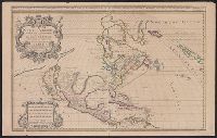
- Creator:
- Berry, William, fl. 1669-1708
- Published / Created:
- 1680
- Call Number:
- 71 1680
- Container / Volume:
- BRBL_00360
- Image Count:
- 1
- Resource Type:
- Maps, Atlases & Globes
- Alternative Title:
- North America divided into its pri[n]cipall parts, viz. Arctick lands, New North Wales, N. South Wales, N. Brittain, Canada, N. Fpance [sic], N. Scotland, N. England, N. York, N. Jarsey, Mary-Land, Virginia, Carolina, Florida, Mexico or N. Spain, N. Mexic
- Description:
- Ireland, this map of North America
- Publisher:
- William Berry,
- Subject (Geographic):
- North America--Maps--Early works to
- Subject (Name):
- Sanson, Nicolas, 1600-1667
- Found in:
- Beinecke Rare Book and Manuscript Library > North America divided into its principall parts where are distinguished the severall states which belong to the English, Spanish, and French / described by Sanson ; corrected and amended by William Berry.
17.
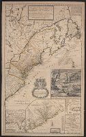
- Creator:
- Moll, Herman, d. 1732
- Published / Created:
- 1715
- Call Number:
- 755 1715
- Container / Volume:
- BRBL_00425
- Image Count:
- 1
- Resource Type:
- Maps, Atlases & Globes
- Alternative Title:
- [South part of Carolina, and the east part of Florida], Draught of ye town and harbour of Charles-town, Map of the improved part of Carolina with the settlements, Map of the principal part of North America, and View of ye industry of ye beavers of Canada
- Description:
- Dedication: "To the honourable Walter Dowglass ... by ... Herman Moll ... ", Hand col. On sheet 103 x 64 cm. Recto: Numbered "11" in ink ms. Verso: Stamped "Yale Horace Brown 1900S"., and Similar to description in Tooley, p. 87, map 55, 1715 (a).
- Publisher:
- Sold by H. Moll over against Deverux Court in the Strand,
- Subject (Geographic):
- North America--Maps--Early works to
- Subject (Name):
- Dowglass, Walter, dedicatee, Moll, Herman, d. 1732, dedicator, and Moll, Herman, d. 1732, publisher
- Found in:
- Beinecke Rare Book and Manuscript Library > A new and exact map of the dominions of the King of Great Britain on ye continent of North America : containing Newfoundland, New Scotland, New England, New York, New Jersey, Pensilvania, Maryland, Virginia, and Carolina ... / by Herman Moll, geographer.
18.
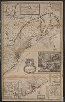
- Creator:
- Moll, Herman, d. 1732
- Published / Created:
- 1715 [i.e., 1726?]
- Call Number:
- 755 1715B
- Container / Volume:
- BRBL_00425
- Image Count:
- 1
- Resource Type:
- Maps, Atlases & Globes
- Alternative Title:
- [South part of Carolina, and the east part of Florida], Draught of ye town and harbour of Charles-town, Map of the improved part of Carolina with the settlements, Map of the principal part of North America, and View of ye industry of ye beavers of Canada
- Description:
- Dedication: "To the honourable Walter Dowglass ... by ... Herman Moll ... ", Hand col. On sheet 104 x 64 cm. Recto: Stamped "Yale Horace Brown 1900S". Verso: Numbered "VIIIth" in ink ms.; labeled "English Dom: in N., and Publication date from Tooley.
- Publisher:
- Sold by H. Moll and by I. King at ye globe and ye poultrey near Stocks Market,
- Subject (Geographic):
- North America--Maps--Ear
- Subject (Name):
- Dowglass, Walter, dedicatee, King, John, fl. 1710-1749, publisher, and Moll, Herman, d. 1732, publisher
- Found in:
- Beinecke Rare Book and Manuscript Library > A new and exact map of the dominions of the King of Great Britain on ye continent of North America : containing Newfoundland, New Scotland, New England, New York, New Jersey, Pensilvania, Maryland, Virginia, and Carolina ... / by Herman Moll, geographer.