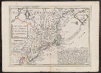
"Observations on which this map is grounded.", Copy 2: Imperfect: southern sheet wanting., Includes compilation data and insets of "A plan of the town of Boston" and "A plan of the town of Boston Harbor from an accurate sur, and Prime meridian: London and Ferro.
Publisher:
November 29th 1774 Published according to Act by Thos. Jefferys geographer to His Royal Highness the Prince of Wales near Charing Cross,
"Observations on which this map is grounded.", Dissected and mounted on linen., Includes compilation data and insets of "A plan of the town of Boston" and "A plan of the town of Boston Harbor from, Prime meridian: London and Ferro., and Relief shown pictorially.
Publisher:
November 29th 1774 Published according to Act by Thos. Jefferys geographer to His Royal Highness the Prince of Wales near Charing Cross,
"Observations on which this map is grounded.", Copy 2: Imperfect: southern sheet wanting., Includes compilation data and insets of "A plan of the town of Boston" and "A plan of the town of Boston Harbor from an accurate survey," ca. 1:150,000., and Prime meridia
Publisher:
November 29th 1774 Published according to Act by Thos. Jefferys geographer to His Royal Highness the Prince of Wales near Charing Cross,
"Observations on which this map is grounded.", Copy 1: Dissected and mounted on linen., Includes compilation data and insets of "A plan of the town of Boston" and "A plan of the town of Boston Harbor from an accurate survey," ca. 1:150,000., and Prime meridian:
Publisher:
November 29th 1774 Published according to Act by Thos. Jefferys geographer to His Royal Highness the Prince of Wales near Charing Cross,
Includes eastern Connecticut ; Massachusetts as far north as Boston, including Cape Cod, Martha's Vineyard, and Nantucket ; and the eastern end of Long Island.
Alternative Title:
Colony of Rhode Island and Rhode Island
Description:
"London Magazine 1778"--Top margin., From The London Magazine (November 1778)., Publisher from bottom margin., Relief shown pictorially., and Sheet measures 21 x 28.4 cm. Inscription on verso: William Akers. Cross Collection no. 198.
Publisher:
Printed for R. Baldwin at the Rose, Pater Noster Row,
Subject (Geographic):
New England--Maps--Early works to 1800
Subject (Name):
Akers, William--Autograph and Baldwin, R. (Robert), 1737-1810
Author statement from McCorkle, p. 40., Includes ill. of animals and coat of arms., Relief shown pictorially., Verso: P. nos. "46", "45"; titles "The Description of New Neatherlands ... ", "The Description, and Verso: Stamped "Yale University Library".
Publisher:
Sold by Tho: Basset in Fleetstreet, and Richard Chiswell in St. Pauls Church Yard,
Subject (Geographic):
New England--Maps--Early works to 1800
Subject (Name):
Bassett, Thomas, bookseller, Chiswell, Richard, Lamb, Francis, and Speed, John, 1552?-1629. Prospect of the most famous parts of the world
"Engrav'd for the Lond. Mag.", From The London magazine. v. 25; Sept. 1756, opp. p. 416., Inset: Fort Frederick at Crown Point built by the French 1731., and Prime meridian: London.
Publisher:
Printed for R. Baldwin in Pater Noster Row,
Subject (Geographic):
New Jersey--Maps--Early works to 1800 and New York (State)--Maps--Early works to 1800